Memory-Map
Maps are downloaded on-the-fly and can be pre-loaded so that they can be used offline. Once the app and maps are loaded to the phone or tablet, cellular network coverage or internet connection is not required for real time GPS navigation.
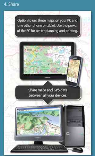
The Memory-Map app can be used as a standalone GPS navigator, but it can also be used in conjunction with the Windows PC app (free download) for planning, printing and loading up maps, waypoints and routes to the phone/tablet.
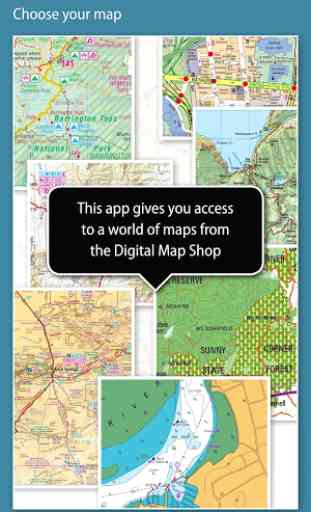
Memory-Map includes free access to 1:250,000 scale topographic maps and many other free maps around the world. More detailed maps are available for download and purchase with a free try-before-you-buy, time-limited demo option. Available maps include Ordnance Survey, Hema, USGS quads, NOAA, British Admiralty, and DeLorme. Maps can be used on your PC as well as your phone and tablet. The Cloud Sync feature allows you to keep the overlay data consistent on all your devices.
Features include:
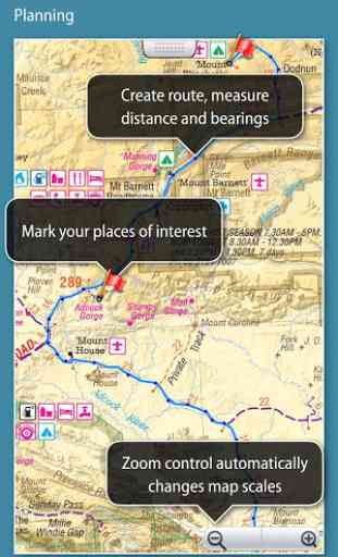
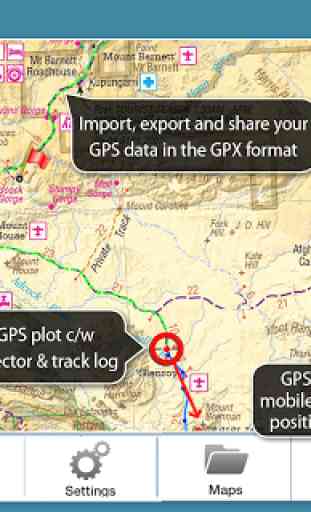
Access a vast range of Worldwide maps and charts.Automatically downloads a free map of your current locationCreate and edit marks and routes.Import and export marks, routes and tracks in the open GPX formatDisplay; Position, Course, Speed, Heading, Altitude and averagesPosition coordinates include Lat/Long, UTM and GB GridUnits displayed in Statute, Nautical or MetricSupport for GPS and Compass sensors, where available.Placename index, can be used offline.Moving map, lock GPS position and automatically scroll the mapRecords breadcrumb trail / tracklogs.Share position marks or tracklogs as GPX filesProximity AlarmFull marine instrumentation features, with AIS, DSC and Anchor alarmNMEA data interface via WiFi or BluetoothAIS collision alarm, with adjustable thresholds for Class A and Class B targetsDisplay Alarm notifications and Nav data on Android Wear watch
"Verdict: The Memory-Map App is a truly excellent, competent product, representing real value for money. It's straightforward to use, with just enough preference settings and options to describe it as customizable. Route-creation and route-following are ridiculously easy to set up, yet provide a tremendous range of route data. You can also import and export GPX files (via email). A really strong product at this price point." Andrew Knight, Yacht Arabella blog
"After buying about 6 navigational applications for my tablet I finally got one that really works the way it should. I now have a handheld version of my sailboat's navigation system. I am very happy with this app and would recommend it to any avid sailor"
"I've tried all the mapping/tracking applications I can find and I rate this best. The 1:25k scale is essential for walkers and the ability to create a route at home or to log it (recording your time & distance etc) as you go along is superb. I like the direction indicator to show where you are heading on the map, the ability to save, describe and name tracks is neat. It's easy to slide the map about from your current position to see where you are heading next, the zooming in and out facility is good. I found it reasonably easy to learn how to use."
"This is not a cheap navigation program, it is a professional tool for viewing raster maps. And for this purpose, it is excellent. For viewing topo maps, this is the best software and hardware combination for the job, this alone was my reason to get an Android tablet, and it was the right decision."
Category : Maps & Navigation
Reviews (21)
I was previously a ViewRanger user which in my opinion was easily the best mapping app available. However ViewRanger was acquired by Outdooractive and in their wisdom forced everyone off Viewranger, hoping we would migrate to their useless app - I tried it and it really is to be avoided, compared to ViewRanger it's rubbish. So I started to look at other apps and so far, for my use in the mountains Memory Map is as close to the performance I had with ViewRanger as I think I'm going to get.
Finicky setup. Very easy to get it wrong. To get it to run properly you need to set it to run in background and accept certain notifications and set to not use battery saving! After several problematic trials I got it working and on a short local run it tracked effectively. However, I'm looking for a viewranger replacement and currently a year long subscription is cheaper on the OS app which offers rather more.
I tried the 10 day free use option in preparation for switching from OS. The concept is good but the Android version has a few bugs. I use the record a route mainly while out hiking and training but I'm very disappointed. It not user friendly and often charts a straight line rather than the route walked or ran, hence the score. Not sure what to do 🤔
Probably my favourite mapping app now that Viewranger is no longer. One thing that would make me give 5 stars is if you replicated the one useful feature that Viewranger had, a central cursor that gave continuously updating altitude and grid ref info. Otherwise I'm quite pleased with the mobile app having used Memory Map on the laptop off of a disc for many years.
Excellent app, commendably straightforward to use. Not a fully featured chart plotter, but it shows you where you are on a map or chart. I've used the excellent value nautical charts, and have recently installed an aeronautical chart to use in a microlight. The ability to print whatever parts of a chart you need at any scale is especially useful, so you can have a paper copy with you if the electronics fail.
Really useful as a back-up plan. Cloud sync lets me plan my hikes using the PC version and access the routes on my mobile. However, never walk on the hills without a paper map, compass and the knowledge to use them as mobile signals can be patchy and batteries do die. That said, on a rainy day and with a GPS app it can be easier to check a screen than a map. Overall I'm very happy with the way it works.
This app enables you to plot your position on an Ordnance Survey map. The main benefit compared with alternatives is that you have the option of making a one off purchase of OS maps for the whole of Britain without the need to pay ongoing subscription. The app interface is a bit clunky and you may need to refer to the instructions to complete some actions because it isn't always intuitive. But if you follow the instructions it does work effectively.
<> THIS COULD BE SO GOOD WITH A BIT MORE EFFORT. One expects more from a paid for product <> I've been using Memory Map for years and this is the worst mobile version yet. <> Many previous features are not there anymore, and after all this time it does not look like they will be reinstalled. <> It is a matter of working with the few features that are left. <> Biggest issue is not being able to transfer "visible" text/notes to the mobile version. What text is available takes many "presses" to view.
This app mostly replicates the functionality of the PC version. However I have not been able to persuade the system to allow me to download for the app a chunk of map. This one could do in v5. While one has cell phone data connection this does not matter, but is no use for out of the way cycling or walking. I would also have expected the display to rotate from portrait to landscape when the phone is turned. It does not. One has to choose the orientation before launching it.
The non stop hints popping up when one zooms in or out is enough to uninstall the app straight away, which is what I have done, and find something not so offputting. If you want success with your app, it might be worth considering removing the abovementioned issue. Seems like a nice app, but all those hints popping up every few seconds is enough to distract anyone. I did disable the notifications settings, but that made no difference.
I use MM regularly in the Pilbara and find extremely helpful. You find in the outback many inconsistencies between different maps. The ability to quickly shift between different maps is often vital. We get into many isolated areas often (doing photography) where there are no roads whatsoever and having the mapping information at hand allows to navigate while maintaining plans for exiting if things go wrong. The ability to have the app both on a phone and a 2 in 1 in the vehicle is brilliant.
Have used M-M in the past and thought I'd give it another go and it does not seemed to have moved on. Very clunky interface (still), and annual map subscriptions are expensive compared to competitors (even cloud-sync is an additional annual subscription). Perpetual licences would be the way to go but I really can't commit to using this unintuitive product for 5+ years to start making savings. The whole experience of phone, Windows desktop app (which is excellent) and the cloud are all very disjointed. Never know, may revisit in the future...
Have been using MM for several years on various platforms. By far the best mapping app around for 4wd in Australia (and of course you can use Hema maps on this app if you desire). Yes, maps can be expensive but no more so than other providers. The new cloud sync feature is a nice addition, but it's implementation is a bit wanting at the moment.
This app could be good if the developers kept up to date with Android. The reliability of features, eg proximity sounds, indexing and accessing maps from the SD card, seem to be phone dependent. The maps are very expensive, and the android app is not of sufficient quality or reliability. God help you if you have re-install android on a device that already has licences. The quality of OS maps is very high - the app is mediocre at best and suffers under investment.
I choose Memory Map because I like to "own" the complete map, and being able to use it across devices and offline is great. Once you get your head around the app, it works well. However the app feels like it's from 2011 not 2021 and can be really unintuitive. MM should invest some of that map ca$h in a better, UX-tested app.
Overall good. Better than the original Hema version. Re Hema. I would like a more detailed map level to be available, even though it would use more memory when downloaded. Re Hema. The original Hema (not MM version) had bugs and often didn't load. MM fixes that. When zooming out, the writing gets too small to read. Could you store more zoom levels each with the appropriate size of writing. Would like to easily download other maps, for example OSM Outdoors. Online map store
Use this all the time, don't need a data connection, sure, the features of the mobile app are more limited than the PC version, but do you carry a printer on the street? Always found it easy to migrate my licences when I upgrade my devices, cost effective with other commercial systems. Wouldn't be without it.
Yes, I use maps, nautical maps of the British Isles, for life for a smallish one time fee, on both my laptop and my mobile. It's irritating migrating them from one mobile to the next and it has various annoying usage idiosyncrasies but you can zoom into the area you want and then print it as your personal map. I calculate distances of the routes I'm going to be taking, bearings etc and these are usually the only paper maps I take. Just occasionally I'll use my mobile to confirm something.
Had MM for over 15 years, I think, for marine and UK OS purposes mostly. The maps are great, the best but the map and licence management process is awful: complicated and confusing. This company needs to put 'average' users at the forefront, and not techies! And do better UX testing for the mobile interface as well as your business to customer processes please. Updated 2022: regressive development continues, with subscription only service. Can't access my old maps. Rubbish customer focus.
Needs more work. I've used Memory Maps for navigating remote areas of Western Australia. The best thing about this app are the maps as they are more detailed than anything much of the competition has to offer. Unfortunately downloading and retaining offline maps is quite cumbersome and sometimes flat doesn't work. The licensing loss of the very handy free map (for quick macro planning) was IMO poorly communicated to users and indicates how the company will respond in future disputes.
This is simultaneously the most long lasting app I have and have been paying for (many years now) and the most frustrating. Yes, it sort of does all I want (offline mapping and charting) but the systems for registration of maps and downloading always fail in multiple ways and take an age (and usually support messages) to make work. Even once registered and maps downloaded there are occasional errors when apparently I have no rights to use maps - so just shuts me out.