Mgrs & Utm Map
It is also a complete helper for mountaineering, trekking and hiking, cross running, scouting, hunting, fishing, geocaching, off-road navigation and all other outdoor activities and sports.
With satellite navigation systems such as GPS, GALILEO and GLONASS (GNSS) supported by your device and your sensors, you can see your most accurate position on different map layers.
Features:
* Easy and Faster
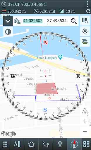
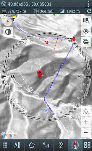
* Compass.
=> Compass on map (on the map that shows your direction)
=> Compass only (shows physical directions)
=> Angular units for compass (degrees and mil)
* Follow Mode
=> The center of the map follows your location while on the move.
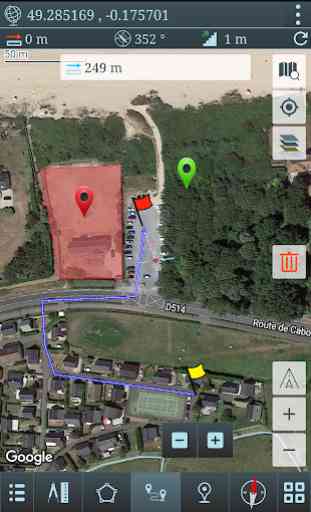
* You can add and removing markers.
* Distance measure. (You can add custom route and calculate total distance)
* Area measure.(You can select an area on the map and calculate the area in square meters)
* You can see the altitude of your location.
* You can find the location according to Degree/Minute/Second , MGRS, UTM or Latitude/Longitude formats.
* Location (Coordinate) format options.
=> MGRS / U.S. National Grid (USNG) (WGS84/NAD83)
=> D°M'S" (WGS84)
=> Latitude/Longitude (WGS84)
=> UTM (WGS84/NAD83)
=> SK42(Gauss Kruger)
* Map type options (Road,Terrain,Satellite,Night Mode,Hybrid)
* You can share location coordinate.
* Distance unit options. (meter and feet).
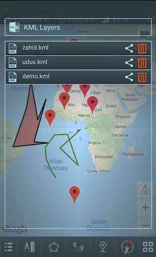
* KML viewer. (Export and import KML layers).
Category : Maps & Navigation
Reviews (27)
I would give a five-star review if the map could display the "grids" for MGRS and UTM. There's an online map that does exactly this but also doesn't give you the ability to place marks and measure distances on the map and also doesn't allow you to to enter coordinates for 100km grids that go past the grid zone border. Otherwise this is the best map program for coordinate systems. Thanks🙃
Foot print tracker comes on. No easy way to turn off. Runs in the background after I close the app. This was a really handy app. I don't mind ads but I can't stand constant notifications that I am getting tracked with no way to turn off.
I love this app. I use it often being in the military, or when I am scouting someplace to hunt as I can plug the grid and load it to my garmin while walking through the brush without pulling my phone out every 50 meters. Love how you can measure distances and how the crosshairs have one red to indicate which way the compass in your phone is pointing. Also appreciate the sat map so so I can see in detail.
I use it to get coordinates in SK-42 to use them in conjunction with old Russian topographic maps. Works perfect. It is fast, interface is straightforward. Visibly a professionally made app. Does not require creepy security permissions, that an app doesn't need. Thanks a lot to the developer!
Good app for free immediate navigation, but takes a minute to get used to it. I haven't paid to unlock other features but there are other apps that provide those features on their free versions such as saving overlays. That is really the main reason for 3 stars. Peer apps are more End User friendly.
please add offline maps capability and this app will be the Top outdoor, hiking, trail map app out for android. Nice and useful simple tools and features. I will buy pro once offline maps can be added. For now theres no point to spend $15 when i cant use without signal.
This app is amazing, definitely get it and then link it up with Gaia or whatever you can get to enable your maps to be save offline. the toolbox is quite packed full of tools... so if you really want to get to know how to use this thing, you're going to have to put in some time. Although trust me... Learn this from front to back and you and your team are DIALED IN.
Great free app with some useful tools. Do not expect 100% accuracy from it, but +/- 10 m for the phone is quite good. Would join other comments about offline mode. Would be very helpful to save some maps for offline usage.
works great. I hope to see the addition of military map control measure symbols and military map symbols like like checkpoints, LPOP, friendly/enemy infantry, armor, etc. maybe some generic symbols like dots and crosses too. phase lines. and an ability to share overlays to other app users would be perfect. it would really make the app much more robust for applications on field problems
This app is awesome. It would be better if it worked offline. When the SHTF and we lose signal, this app becomes useless. Need to be able to upload offline maps.
I've used this app for a few years and love the ease of use and accuracy. Have not had a problem on proofing landnav courses when using this and a DAGR. Almost identical in it's precision.
It's easy to use, accurate, intuitive and responds quick to actions. The only thing is missing is the ability to save named waypoints
Great app. Does a lot. In ways it's still better then their new app to replace this one. Will change review and purchase full app when either the price drops by at least half or they ad grid squares as an overlay.
Best app, especially for MGRS. It works everywhere, many times better than google maps. It's clear, simple to use, and offers many options and overlays to use within the maps.
It is a good and interesting app. special for site Surveying who they are working one landscaping and infrastructure work. I'm not saying 100% accurate but it works good within your leastcount. please unlock pro for more information.
Awesome app. I originally thought that I wished I could toggle between degrees and mils on the compass and then the developer replied within hours to tell me how easy it is to do just that. Amazing product and great support!
Not bad. Have used in the field (military) and found it uses extraordinary. Additionally, appreciate its route plotting feature. Definitely worth considering
The new update is not nice. The colored flags and point icons were removed and replaced with same color icons with different symbols. Need to have an option to change the color.
I downloaded this app because I wanted to map the area around my property but could not find any instruction settings for it which made it very difficult to use. Unfortunately it appears to be an app I could use and enjoy.
Too flakey. Lines on map come and go for who knows why. About as intuitive as running a turnip processing plant. Ad handling is too intrusive. Got rid of this thing off my phone. Ugh.
very nice for free. only two "commercials". one small add at the top of the screen. one pop-up when you close.
The only reason I don't give it a 5star is because if your out of service, it cant update the ground features. I usually have to update the ground features before I go off service of the general area I would be operating in. Otherwise an Awesome app!
Reason for four stars is there hasn't been an uploaded map for at least a year. I live in Las Vegas and the current map still shows a dirt lot where Raider stadium is supposed to be.
one of the best map orientation apps I have found that is available. it is available for both android and IOS which is an added bonus for cross communication.
Imagery is reasonably up to date, controls are easy to use. One of the best maps apps I've used to get coordinates
if it was more like the "land nav" app, I would consider using. I use mgrs maps and nav everyday for work.
Fantastic app. My only complaint is the lack of offline functionality. If i could save maps for offline use it would be perfect. As it is you can still preload an area you are about to go into by zooming in and scanning around. The area will be stored short term, but you risk losing it if you turn off the app or turn off your phone depending on your memory settings.