Mgrs & Utm Map Pro
It is also a complete helper for mountaineering, trekking and hiking, cross running, scouting, hunting, fishing, geocaching, off-road navigation and all other outdoor activities and sports.
With satellite navigation systems such as GPS, GALILEO and GLONASS (GNSS) supported by your device and your sensors, you can see your most accurate position on different map layers.
Features:
* Easy and Faster
* Compass.
=> Compass on map (on the map that shows your direction)
=> Compass only (shows physical directions)
=> Angular units for compass (degrees and mil)
* Follow Mode
=> The center of the map follows your location while on the move.
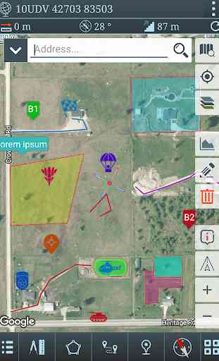
* You can add and removing markers.
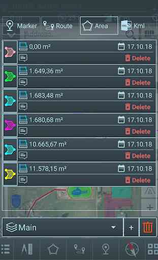
* Distance measure. (You can add custom route and calculate total distance)
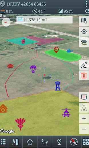
* Area measure.(You can select an area on the map and calculate the area in square meters)
* You can see the altitude of your location.
* You can find the location according to Address, Degree/Minute/Second , MGRS, UTM or Latitude/Longitude formats.
* Location (Coordinate) unit options.
=> MGRS / U.S. National Grid (USNG) (WGS84/NAD83)
=> D°M'S" (WGS84)
=> Latitude/Longitude (WGS84)
=> UTM (WGS84/NAD83)
=> SK42(Gauss Kruger)
* Map type options (Road,Terrain,Satellite,Night Mode,Hybrid)
* You can share location coordinate.
* Distance unit options. (meter and feet).
* KML viewer. (Export and import KML layers).
Special features at pro version:
* More maps (Cycle, Topographic etc.)
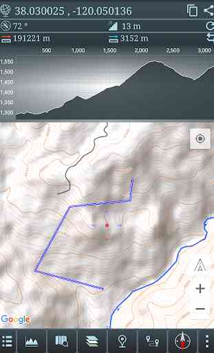
* You can see the elevation profile of your route on the graph.
* Location search by address.
* You can add map layers for markers.
* List view for routes, polygons, markers and KML layers.
* Multiple routes and polygons.
* More and colorful map items.
* No Ads.
Category : Maps & Navigation
Reviews (27)
Awesome route overlay ability. 1. The route and marker icons aren't showing up when I turn them on and off after a route was emailed to me from a friend and then opened in the app. I have to click each route icon individually. 2. Add grid lines for map usage. 3. Make actual military map icons to utilize for different overlays.
I really would like to see a good measuring tool.. IE: a movable point a and b for quick reference.. As well as distance and bearing for each leg of a route, considering its straight... Also how do I get my Compass into magnetic. When I select magnetic it's still in true. Thanks -Matt
Giving it 4 stars because of the True and Magnetic North issue. Am I the only one but the MAG N reading is off.If this could be resolved would be a perfect app for a active duty soldier but at this point still have to calculate and adjust to get a correct bearing. If to hard to make the app calculate it, make it possible to adjust manual for GM angle in the options . Add possibility to put a grid square on the map and make GRGs, standart NATO simbols.The rest is pretty excellent.
This application has been amazing and helped with all of my planning, highly recommended. Only issue I have had is changing the colors for icons and lines, it is most likely something I am doing wrong. Has anyone else had this issue or come up with a solution?
Variety of detailed map layers and helped a lot in my current field of work. Can draw graphics, routes, area, adding colors, allowing color opacity to see underneath the map layer. Recommend this app for anyone who hike or go outdoors or military
I bought the Pro version. I opened the KML File from WhatsApp. The file read at box Imported file. Then I try to click it. Suddenly the screen fadeout. Please fixed it because I bought it in order to use it. Not for showing.
I love this app. Can you download maps for off-line use? I use it all the time for training events to mark training lanes, and land nav. It is easy to mark points lots of options for markers.
Very Nice app! Helps a lot when trying to navigate through unknown terrain! Only small thing would be nice: an option to show the magnetic declination on you current position in your degree or MILS
Amazing Map Tool I love that it keeps the maps for offline use, But i cant figure out how to see the elevation profile, And can you add letting your phone take height readings to make your own more detailed topo map. Thanks for the great app
This app helps me a lot in my hiking experience,easy to use and accurate.I know there is not an option for offline use but I'm sure you will add this in the future.I have bought this app for my second phone that's kinda old and outdated and still it works perfect.Thank you and keep up the good work 😁😁
The only thing that doesn't have it's offline maps (open street maps) or the hability to work on raster images. It would be epic if one Day it's included. Also would be nice if icon post edit could be done.
An excellent app with lots of functionality. The inability to download maps for offline use is the only negative.
Considering this is for traversing difficult terrain I find it absurd that there isn't an offline mode. A lot of hiking is in places where there is no service.
Not bad..! I work in Range Control on a military base. I use this app to quickly walk & verify the checkpoints on our land navigation course.
please please please please, add regular nato symbols and equipment symbols to this app, also add grid lines, and offline maps. do that and this app would be 5 stars and perfecttttttt. Please add these features!!!
Great app. I have the pro version. Please add offline though since using in the field is terrible cause you can't without service Also is there a way to make it calculate a driving route?
Just downloaded. It looks like it will do what it advertises but there are NO grid lines. Please add grid lines and this app would be 4-5 stars. I will post an updated review after some use.
I use this all the time for work and it's amazing. Very accurate GPS and if you play with the features you can do some pretty cool stuff with this app
great app, helps with work! question is it a one time payment for the pro version? also you should integrate a way to mark and name things without having to drop a marker
Best all rounder Navigation app I have used. uncomplicated and practical to use while moving. easy 5 stars!
Good stuff, very acurate. Could use more functions but even as it us its great map for Airsoft and similar stuff.
I love the app. The only draw back of this App is the lack of grid lines. If there were grid lines i would rate 5 stars
Works great for me. As others have requested, I would also like to have offline maps added. Very well done.
Is usually great. I can no longer import kml's and have them stay. I can "show temporarily" but I can not embed kml.
perfect app ! compliment !!! hope soon you will add OFFLINE MAPS .... not everywhere we can conect with the internet... but at all the best i found !!!
Great app and the developer is a great person. He's very helpful and a credit to the human race. I highly recommend his apps. I can't wait to see what he comes up with in the future. Thanks again for your help and support.
Excellent application! Orienteering becomes a cinch, can easily replace your conventional map in digital format. Very easy to learn, and contains tools that are extensive in functionality. Would like to see the capability to move objects between overlays once they are placed, and downloading of mapgrids for use when working offline.