Mobile Topographer Free
The leading tool for the professional surveyor offering the best accuracy and extensive functionality that no other app can!**
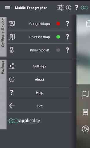
* Increase GPS accuracy using:
- Weighted averaging (on every axis).
- Map calibration.
- Device calibration on map, or on a know point.
**
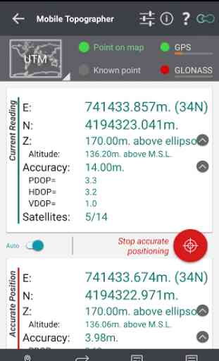
* Display and convert GPS geodetic to Cartesian EN coordinates and back:
- UTM.
- Europe ETRS89/UTMZ28-38.
- Hellas HGRS 87 (EGSA 87).
- Hellas HGRS 87
- HEPOS.
- Hellas HTRS07/TM07.
- Iceland ISN93/Lambert 93.
- Morocco Merchich.
- SPCS83 (124 zones) USA.
- Romania S-42(58)/Stereo 70.
- Lebanon & Syria Deir ez Zor/Stereo.
- Croatia HTRS96/TM.
- Serbia SRB-ETRS89/UTM, SRB-MGI/Z7.
- Australia MGA94 (GDA94), AMG66 (AGD66) National, A.C.T., Northern Territory, NSW & Victoria, Tasmania,AMG84 (AGD84).
- Former FR of Yugoslavia MGI Balkans zones 5,6 & 7.
- Italy Monte Mario West Zone 1 Peninsular, West Zone 1 Sardinia, East Zone 2 Peninsular, East Zone 2 Sicily.
- Costa Rica CΜ05/CRTM05, Ocotepeque 1935 Costa Rica Norte & Ocotepeque 1935 Costa Rica Sur.
- Cyprus CGRS-93-LTM.
- Hungary HD72/EOV.
- Kosovo KosovaREF01.
- Latvia LKS92/TM.
- Lithuania LKS94/TM.
- Spain ED50/UTMZ29-30 NW, ED50/UTMZ29-31 ML & ED50/UTMZ31 BA.
- Uk's OSTN02/OSGM02.
- Turkey ED50/Gauss-Kruger 3° Z9-15, ITRF96 & ED50/UTMZ35-38.
- Luxembourg LUREF.
- Venezuala REGVEN/Z18-20.
- Sweden SWEREF99 TM.
- Argentina POSGAR 94 & POSGAR 2007.
- India Kalianpur 1975 ZI
- ZIV.
- Algeria Nord Sahara 1959 / Z29-32.
- Armenia, Georgia, Azerbaijan, Estonia, Latvia, Lithuania, Russia
- Kaliningrad and Kazakhstan Pulkovo 1942/ CS63 (A)Z1-4, (C)Z0-2, (K)Z2-4.
- Central and South America SIRGAS 2000.
- Nigeria and Cameroon Minna 1996 & 2008 MTM West, Mid, East Belts & UTM Z31-33.
- Bangladesh Gulshan 303/TM.
- France RGF93/CC42-50.
- Canada CSRS
- Egypt 1907 Blue, Red, Purple, Extended Purple belts.
- Portugal ETRS89/PTM06.
- Netherlands Amersfoort/RD new.
- Qatar QND95.
- Colombia MAGNA-SIRGAS Far West, West, Bogota, Central East, East zones.
- Mexico ITRF 2008/LCC.
- Madagascar Tananariva (Paris)/Laborde & Tananariva/UTM Z38-39S .
- Tunisia Carthage (Paris)/Mining Grid, Carthage/Nord, Carthage/Sud, Carthage/TM 11 NE, Carthage/UTM zone 32N.
- Liechtenstein CH1903/LV03C-G.
- Switzerland CH1903/LV03 (old), CH1903+/LV95 (new).
- Brazil SAD69/UTM Z18-25 & SAD69(96)/UTM Z18-25
- Spain Canary Islands REGCAN95/LAEA & REGCAN95/LCC & REGCAN95/UTM Z27-28
**
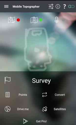
* Auto stop for accurate positioning.
**
* Examine the satellites above you in a sky view.
**
* Signal strength and number of satellites indication for each GNSS constellation individually.
**
* Multiple units support:
- Meters,
- International feet,
- US survey feet.
***Height calculation:
- Ellipsoidal height.
- EGM96 orthometric height calculation.
**
* Convert from geodetic to Cartesian coordinates and back:
- Support for device measured points, or
- Manually input of geodetic or Cartesian coords.
**
* Drive me:
- Key in coordinates of the target point in either geodetic or Cartesian coordinates, or select a point from the list and follow the pointer.
- Compass indicating both magnetic and true North.
**
* Project on Map:
- Project individual points on any map application.
- Project list of points, and the defined polygon, on embedded maps.
**
* Save multiple point lists, to use them later.
**
* Calculate area.
**
* Export point lists το:
- .txt (text file)
- .csv (point file
- comma separated)
- .kml (google earth file)
- .gpx (Gps Exchange format)
- .dxf (drawing file)
**
* Send file via e-mail, or upload it to cloud.
**
* Complete help text support.
Help us improve Mobile Topographer by e-mailing your comments and suggestions.
TAGS: Survey Surveyor Property GPS GNSS GLONASS QZSS BEIDOU GALILEO
Category : Productivity
Reviews (26)
Im a civil engineer and i try to measure 2 points with the same elevation and the accuracy when measuring was 0.61 and the result was not satisfying . The error between measures was 2.12 m in elevation . I may say its the best try for that kind of usage on mobile and it stands above all but I still can say that its not good at all about accuracy ... An answer by devs would have been good .
After a long time I found one of the excellent app and it has gave almost accurate reading.i compared survey done coordinate it was found less than 2meter error. Thank you very much who made this app.
This is really useful. Gives accuracy to half a metre quite quickly. Height not so accurate but overall its more than good enough for my proposed.
Co-ordinates were accurate. But, the elevation was wrong. Is it because my smartphone does not have barometer ? Does the application work fine even without barometer ?
This app is far more accurate than handheld gps i use,ive picked coordinates using both handheld gps & mobile topographer & ploted them in arcmap,its the best & most accurate app. as regards coordinates
not trying to be a critic but you can't get an accurate measurement on your phone for GPS data. just hope no ones really using this to topo a building
Good morning, I really like d app. But it just stop on my phone. Any time am try to launch it, it just display ACTIVATE SATTELITE RECEIVER (infinix hot5)
The app crashes in Mi6 pro.... This is very annoying... It is working for all other phones... please release a patch for it...
fantastic app, I used it for my dissertation work... it gave me 0.5m - 0.2m accuracy and perfect marking in ArcMap as well... GOOD GOING guys...just loved it...thank you...
Very nice. In addition, is there any way that I can customize coordinate system and add a geoidal model?
Very good application. I am just wondering: If I have callibrated against a known point, can I use "accurate positioning" to additionally improove the precision? Thanks
A Really nice app. Please make it possible to add more details (maybe unique identification) to the saved points.
A good app but need improvements. Its accuracy is bit less then other equipments I have tested it with
Its really a good app and is working perfectly compare to handheld GPS.. Kudos to developer.
Gnss, atleat one satellite is not appearing for me unable to pick the points. Please tell me if i want to change the settings
Good, but the accurate positioning in SURVEY option stopped working after the day two.
This app is good especially if you are travelling in the middle of the jungle
Is this is more useful to create a position of the Earth and using locating the land with co-ordinates of survey
Not good improve the quality non network area and it's display report also semple
Really good and a mandatory application for all surveyor
Very usefull as a backup for GPS.
GPS coordinates randomly stop updating, useless.
The height is not correct, there is written -18m msl but in my GPS Garmin 22 m msl
Satellite are not connecting speed
Any chance of adding altimeter/barometer readings to the application?
I can't believe the number of people who think their phone will give them survey grade data and complain when it doesn't. Buy a survey grade receiver! This app is awesome for a freebie! I would buy the Pro version in a second if it had geoid model and antenna height support.