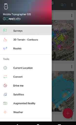
Mobile Topographer GIS
You can now perform a complete survey without any limitations into complexity or volume of data.
Try now Mobile Topographer GIS by using the three days free trial period. Just download the app and proceed with he subscription procedure. Although, you will be asked to provide billing information, you will NOT be charged before the end of the three days of the free trial period. You can cancel your subscription at any time during the three days trial period, free of charge. Charges will only occur, if at the end of the three days you still have an active subscription.
- Collect GNSS readings using increased accuracy (GPS, GLONASS, Galileo, Beidou, QZSS constellations supported).
- Connect your external GNSS receiver via mock locations and use Mobile Topogrpaher GIS as a processing unit.
- Display data into WGS84 or you local projected CRS.
- Convert from WGS84 to local projected CRS and vice versa.
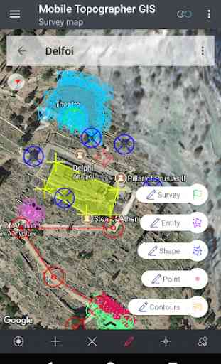
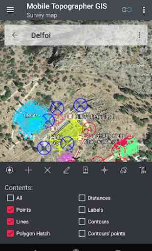
- Real time projection on map.
- *** NEW *** Custom image or WMS server as map background.
- Find a marked point in the real world by using "Drive me"
- Calculate Orthometric height on the fly using EGM model or local elevation grids where available.
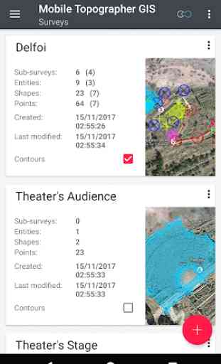
- Organize your work into Points - Shapes - Entities & Surveys. You can now create individual points, multi-point groups, multipart polylines, and multipart polygons with holes.
- Create a full drawing with as much details as you want.
- *** NEW *** geodetic tools. Add indirect points via on of the following options: 1 point + Distance + Azimuth, 2 points + Distances + Select, 2 points + Azimuths, 3 points + Distances, Midpoint of line, Divide line, Extend line, Parallel line, Perpendicular to line.
- Nest your jobs, in any nesting level, to create a super-survey.
- Share data between jobs with active links.
- Exchange jobs between your mobile device and your desktop computer, with import - export functions using all common formats .txt, .csv, .kml, .gpx, .dxf and Shape files (.shp - .shx - .dbf)
- Collaborate with your partners by exchanging and sharing from one point to complete jobs.
- Create the 3D terrain of an area by simply walking through it.
- Calculate contours and add them into your survey with lightning speeds.
- View a real 3D model directly into your device.
- Store a route with its data.
- Show GNSS satellites with signal info in both compass view or AR.
- Backup and restore your data using an SQL .db file.
Welcome to the era of mobile surveying...!
Find more about Mobile Topographer GIS in:
http://applicality.com/projects/mobile-topographer-gis/
Download the user's manual from:
http://applicality.com/app_documentation/web/MobileTopographerGIS_Manual.pdf
Category : Productivity
Reviews (29)
This is really working coordinate collecting tool that I havr used ever. Really good work with high accuracy.
New version 6.0.2 works with Android 11. Mail to support goes unanswered.
It is not functional and request to buy pro
now you have to pay annually for using the app, it was a good app, but definitely not worth paying that much for using it. Extremely Expensive.
No support for NTRIP to my gnss. Cancelled in less than 24hrs of trial period. Now trying to find out how to cancel the payment. Rating will change if credit card not billed.
Better if not ask for precondition.
Please I need a refund, after the first day of trial (January 13, 2021), I cancelled my subscription. As at today, 6 February 2021, I'm yet to get my refund
I need this app without subscription
There is no fun of downloading if it can not be used without a subscription. Uninstalling right at first start. Poor strategy by vendor
Cannot activate GNSS receiver
Not everyone can afford to pay this app it's a good app but you need to make one for students too guys thanks Then it keep saying my Google service don't support My device am using the infinix s5 lite old can you review it
At least one should know what he's paying for, give some days free trial without adding a payment method
Could suggest gnss receiver which is compatible with your application, my business is area survey below 100 acres and measuring distance between two points I hope This application fullfils my needs
It's good resource especially for the GIS users and students....
This might have been a waste of money. No help available, not intuitive.
The app isn't working well for me at all.
Demands an unnecessary permission then refuses to work without a subscription.
Even gaint apps like whatsapp not charging any free but you are charging a bulk amount of 2300 for one year.
What a piece of cr*p. Stay away from this.
Why force to pay if that is 3 days free trial What do you think you are alone in the market .. uninstall
I love this app, pls did you have some guidelines on how to use it efficiently ??
It asks for unnecessary permissions and then asks you to oay to use
It would have been better if more datum are included like addinan ethiopia
Hand held with a good accuracy
The app force to buy subscription at the very beginning.
Very useful for topographical survey
This app is asking for subscrition before it open saying no sub it cant open why thisust be free now not good enough
crashes without subscription
Completely useless if you have a problem and need support. Enjoyed MTpro but needed functionality of GIS. Spent my trial period trying to fix an install error and waiting for a response from support. Several days and two emails and never a response. Mine doesn't work nor can I tell you if it works with my previous surveys done in pro. Nobody home!