Mobile Topographer Pro
The leading tool for the professional surveyor offering the best accuracy and extensive functionality that no other app can!
Only in Pro:
**
* Export data in the standard of GIS Shape files (.shp)
**
* Import file
- Import points from file in WGS84 format or CRS of your choice
- Import points from text files (.txt, .csv) or Shape files (.shp)
**
* 3D Terrain modeling & contours
- Collect terrain data
- Create a 3D terrain model
- Create contours
- Show on map
- Load, save, export 3D terrain model and contours
**
* Route tracking
- Track your route
- Process route
- Get statistics
- Show on map
- Load, save, export route
**
* Real time map projection while surveying
**
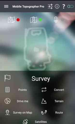
* Survey on map.
- Complete a survey without even going to the field
- Insert, modify or delete points directly on the map
- Correct or make additions to an existing survey
**
* Group points
- Divide your list of points in groups
- Filter list of points view, by naming groups
- Export list of points with group division or filtering
- Select the contents of the exported lists of points
**
* Device Elevation
**
* Auto survey mode
**
* Area, Perimeter, Number of vertices of polygon
**
* Manually edit coordinates of a point
- Key in the new coordinates
- Reposition a point using drag & drop or edit mode
**
* Swipe from left to view satellites while surveying
**
* View GNSS satellites in Augmented Reality
**
* Full functionality even without internet connection
**
* Maps v2
**
* Weather
**
* Increased accuracy(For even better accuracy, you can link your device to an external GPS receiver)
Plus the well known features of Mobile Topographer Free:
**
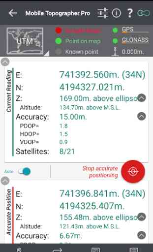
* Increase GPS accuracy using:
- Weighted averaging (on every axis)
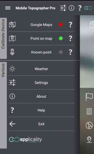
- Map calibration
- Device calibration on map, or on a know point
**
* Display and convert GPS geodetic to cartesian EN coordinates and back:
- UTM
- Europe ETRS89/UTMZ28-38
- Hellas HGRS 87 (GGRS87
- EGSA 87
- ΕΓΣΑ 87)
- Hellas HGRS 87 (HEPOS)
- Hellas HTRS07/TM07
- Morocco Merchich CS
- SPCS83 (124 zones) USA
- Brazil & Central and South America SIRGAS 2000
- Brazil SAD69/UTM Z18-25 & SAD69(96)/UTM Z18-25
- Australia MGA94 (GDA94) & AMG66 (AGD66) National, A.C.T., Northern Territory, NSW & Victoria, Tasmania & AMG84 (AGD84)
- Italy Monte Mario West Zone 1 Peninsular, West Zone 1 Sardinia, East Zone 2 Peninsular, East Zone 2 Sicily
- Spain ED50/UTMZ29-30 NW, ED50/UTMZ29-31 ML, ED50/UTMZ31 BA.
- Uk's OSTN02/OSGM02
- Turkey ED50/Gauss-Kruger 3° Z9-15 & ITRF96 & ED50/UTMZ35-38
- Argentina POSGAR 94 & POSGAR 2007
- India Kalianpur 1975 ZI
- ZIV
- Central and South American SIRGAS 2000
- France RGF93/CC42-50 Auto & manual
- Canada CSRS (19 systems)
- Carthage of Tunisiaand many more... (http://applicality.com/supported-coordinates-reference-systems/)**
* Multiple units support:
- Meters
- International feet
- US survey feet
**
* Height calculation:
- Ellipsoidal height
- EGM96 orthometric height calculation
**
* Convert from geodetic to cartesian coordinates and back:
- Support for device measured points, or
- Manually input of geodetic or cartesian coords
**
* Drive me:
- Key in coordinates of the target point in either geodetic or cartesian format, or select a point from the list and follow the pointer
- Compass indicating both magnetic and true North
**
* Project on Map:
- Project individual points on any map application
- Project list of points, and the defined polygon, on embedded Google maps
**
* Save multiple point lists, to use them later
**
* Calculate area.
**
* Export point lists to:
- .txt (text file)
- .csv (point file
- comma separated)
- .kml (google earth file)
- .gpx (GPS Exchange format)
- .dxf (drawing file)
- .shp (shape files)
**
* Send file via e-mail, or upload it to cloud
**
* Satellites sky view
**
* Signal strength and number of satellites indication for each GNSS constellation
**
* Support of all GNSS constellations:
- GPS
- GLONASS
- QZSS
- BEIDOU
- GALILEO
**
* Complete help text support
Category : Productivity
Reviews (29)
Well done guys. I had a problem with the app initially but you have fixed it well. Very quick calculation algorithm now in place and contours calculated very rapidly. Very good to see app development take place that has good positive outcomes. App now very much worth the money spent. Thank you.
Finally got this app to work with external gps via Bluetooth - struggled but didnt get aupport from the developer. The trick was to enable mock gps en my phones developer settings. Had to fist enabke the developer settings to get to this settings. Next i installed an app called GPS connector. You need to select this app in the developer settings as the mock app. This connects to your external gps via Bluetooth. Once connected using this app, open mobile topographer and select Survey! Boom!
I wasn't able to set data points into the app to help direct me to points on my land. For that reason I canceled this after several hours of trying to make that happen.
I have the app but I don't think this can convert a CORS tower data from one coordinate system to work with another coordinate system on my hardware.
Can't import any files. Even the ones I create in app and save
I have been asking for an Ireland CRS for over a year, promises not kept. Useless to serious users in Ireland without it.
Plz dont puchese to this app... Its not supported to all mobiles... I loss off my money.... 1800 Rs... 👎👎👎
Good app but I want to know the difference between distance and length when using the route tracker option in pro version.
Sir tody I'm subscribe mobile topographer , app is running but satilites are not receive plzz tell me .
With a little help from support this is working perfectly. Linked to the Emlid Reach Mobile Topographer makes layout possible and survey much easier. Now looking into GIS for even more functions.
It's not working!!
This app is not providing contours properly and is too much time taking so I want my refund
Developers are unwilling to accept additional coordinate systems. Despite numerous attempts to contact the developer, they ignore any communications. Which is a great pity since I have recommended them to the growing population of mobile RTK users that are looking for a platform like this.
Very bad accuracy, cannot be used in field :( Hope to get a refund
I use it almost every day and it has proven to be the best i came across of about 25+- i tried..For those in the field of Land Surveying,I recommend to give it a try.
Can not hit the same point twice. Complete waste of money.
Needs custom coordinate systems! Parameter input from Trimble site calibration would be ideal.
It has great accuracy. You can survey in every geodetic system.
I am a Land Surveyor and I found this app very useful. It is really amazing to see what it does. Kudos to the developer(s). Only one thing I feel is not accurate are different in heights between points. Calculated contours are far from accurate. Maybe I am the one not doing it right. However, this is an app for mobile device. I have not seen one close to it. Good job!
Excellent app! I couldn't find a comparable alternative on the market. It helped me verify the size of the land I was buying, saving me a lot of time and money. I bought the Professional version of the app just to support the development of this excellent piece of software.
A true survey tool, very accurate, feature-rich and with a well-designed UI.
Best gps app eva
I had a question about the app and my mail get answers immediately from the developer!
Fully does what I expected from it, surveyed my whole property (~10ha) with it, and perfectly did the job. Just had to watch that the raw accuracy was always at 3m, then the final accuracy was better than 1m! Also the area calculation works great!
Αξιολογότατη προσπάθεια. Θα ήθελα να υπάρχει η δυνατότητα στην οθόνη "survey on map", παράλληλα με το πολύγωνο που εμφανίζεται στην οθόνη, να εμφανίζεται και η τρέχουσα θέση μου, ώστε να γνωρίζω που βρίσκομαι σε σχέση με τα όρια του πολυγώνου. Ελπίζω σε μελλοντική αναβάθμιση να προστεθεί αυτή η δυνατότητα. Συγχαρητήρια!
I'm buying this product hoping that this kind of feature is available but not here. Can you include this feature and making this product is point to point micorawave LOS calculations compatible? Thanks
After lot of searching I found the app I needed for my mapping needs. I will add the 5th star if you add shapefile import/export support.
I used this app to measure Sq yards of seeding on my city projects and measures very accurately Saved the city thousands of dollars of over payments. City survey crew spot checked and confirmed accuracy. Nice application and thanks for developing it.
Is it possible to choose the geoid model, or instead set EGM2008 by default? Also, it would be useful if the contour interval can be set to less than 1 m, at least 20 cm would be ok, as there are many bluetooth RTK reciervers to connect to this app, we need a more precise view of the data.