My Elevation
Notes: ● The application shows the surface elevation above sea level based a latitude and longitude. It does not provide altitude in cases were you are in an aircraft, high up in a building, or high off of ground for some reason.
● This application must have a working data connection to be able to show your position on the map, get your precise elevation and provide much additional rich content . It does not have an off line mode. Please consider this before giving poor ratings when it doesn't work when you have no data connection.
Feature List
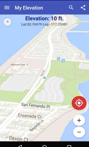
● Follow Me Mode
- Follows your current location in real time. Watch your movements on a map and see your elevation and coordinates updating as you move.
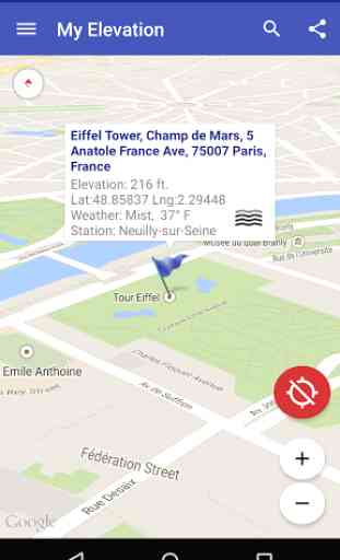
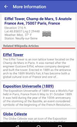
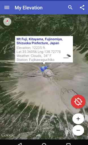
● Search for Locations and watch the map fly over to them. My Elevation will tell you the weather there and let you browse Wikipedia articles about attractions nearby the location. If your curious at all about other places you will love this !
● Long press a location on the map and My Elevation will tell you the weather there and let you browse Wikipedia articles about attractions nearby the location.
● See street level view panoramas of places you search for or locations you long press.
● Share your location or what you find in searches with your friends in a text or email.
Display OptionsMap Mode
- Lets you pick one of four Google Map types (Normal, Satellite, Topo and Hybrid)2D/3D Maps
- Toggle between the two modes
Try it out and let us know how it goes. email us at [email protected] or visit https://www.facebook.com/MyElevation
This application uses Google Analytics to collect anonymous data about how the application is used and what failures occur. This allows us to make the application better with each release. You can opt out of this by un-checking the Analytics data item in the application preferences. No personally identifying information is collected.
Category : Travel & Local
Reviews (24)
I like this app. It's 3D use of what looks like Google maps to show the shape and dimensions of the buildings and parking areas is incredibly accurate. Kinda freaky, in a good way. It would be nice if the elevation part functioned offline, even without the map features, but I understand that it doesn't.
It's incredibly easy to use and the features are extremely relevant and helpful. The speed at which it updates while driving is perfect! The accuracy of the elevation display is always within a foot Or so of elevation signs
The app measures elevation ok on flat land, between climbing or driving up to higher elevations, mountains, etc. It is worthless, looses connection with GPS satellite, etc. Of course, it could my mobile phone carrier, but doutful
It updates elevation quickly and constantly. I used this app quite frequently when traveling from Alabama, to Utah, over the Continental Divide, to Yellowstone, throughout Wyoming, and back. It was fascinating to know the variations in elevation as we traveled.
There is no better app for finding your altitude above sea level. Use this for calibration of altimeter and barometers regularly. Just needs a data connection, no reliance on barometric pressure.
Very nice app to use especially when you're in the mountains let you know what gear to put your car into if you happen to bring an inhaler with you and just if you're going to be light-headed or not. It's my privilege to use this app traveling in the mountains
Like all GPS based elevation apps, there will be some variations. However, it's definitely close enough for everything but government work.
I am a licensed commercial drone pilot, and being able to quickly and accurately record my elevation in log book is great. I am very impressed with how fast and accurate My Elevation is.
I think this app is fantastic! It's very easy to use, accurate and loaded with information. The interface could define the term "intuitive", it's that good. (Microsoft, take a lesson). I've tried other elevation software but nothing I've tried even comes close to to My Elevation in terms of speed, accuracy, volume of practical information included, number of alternative views available and overall design. I love it!
Good App - No way to upgrade. I installed free version, used it for a few days then attempted to buy it but no option to do it. You only get that option before you buy it. Once you try it, you can't buy it. Too bad ...... uninstalling, and looking for another app. Also the search feature does not work. When you enter the address there is no button to start the search.
As far as I'm concerned, this is THE ONLY elevation map/calculator to use. Elevation, shown in 'ft.' above sea-level, is a smooth progression, in increments of one foot, (in distance, and in height, where applicable, which is, almost everywhere - I haven't discovered any deviations from this). Incrementation updating is very fast. The app mimics Google Maps©, very closely, so those familiar with that app, will feel right at home with this one. I would have named this app, "All Elevations", rather than, "My Elevation", however, since it does provide far more than one's current elevation. Spot-on!
Works fine with data service, but can only give coordinates without elevation when there is no data connection, so often pretty useless if you want to use it for hiking. I'm guessing the app is just cross referencing coordinates with some elevation database. I've found some apps that tap into the full suite of sensors in my phone that can use only gps to calculate the elevation when this app fails. The interface is better in this app but that doesn't matter when it can't do its main function.
Ive never had a problem with this app. Any time i want to know my elevation i go to the app and within 30 seconds i know how high i am. I would give it 5 stars but im waiting to see how it all works out before i do that. But overall a great app.
Exelent tool if you need to know your elevation. I have traveled the country and have frequently used to check my elevation in mountains of Colorado.
App does not provide elevation without network access. Offline access is critical for my use case where network access is typically unavailable.
Only gives ground heights from Google maps so if you're up in a plane or up a two story building it won't record it. Also the maps it gets its data from isn't totally accurate. It was 8m out at one stage for a spot height. Not recommended. Edit: Sorry. I never bothered to read it. I was just testing apps without reading.
Love this app! I use the hybrid view and it helps locate your position using landmarks you can identify. The longitude and latitude is always a plus!
How do you keep it from spinning around every time I go to the screen it spins around and they lose my coordinates just keeps every time it goes it spins it spins it spins how do you keep it from spinning without taking the GPS off
I really like this app. I primarily use it for long distance shooting inputs. It works great and is very fast.
My far the most accurate app I've used so far to find my exact elevation. I hope one day it will have the capacity to record my bike rides.
Good app; as far as I can tell the terrain altitude is accurate and unlikely to change over time (satellite generated). However, not sure how often the developer updates the map data, I bought a new-build home in a newly developing community more than 2 years ago. While the app accurately locates my home, the majority of the subsequent construction is missing.
Elevation is wrong. I go upstairs in my house and app shows same elevation as downstairs. Update: The developer explained the ground elevation is looked up via internet from the lateral GPD coordinates. Sorry I was stupid not reading "about". Upgrading to 3 stars for now. Would like to know what lateral resolution we get. Update: Upgrading to 5 stars because the support is phenomenal. All my technical questions to accuracy and source data have been answered!
Seems accurate most of the time. I'm able to check it's accuracy on our hilly property and for the most part it works well. However, there are moments it is not even within 30 ft. Fun for curiosity, but I wouldn't consider it as a serious navigation or surveying tool.
Although the app seems to use Google earth for its database, it is nowhere as accurate as Google earth, or the actual land elevation in real life. I recently did a professional survey on my land wich revealed an elevation of 5 meters. This app measured the exact same place to be 25 meters, 5 TIMES WHAT IT IS. In fairness, the terms and conditions do state that the measurements are not accurate, and are only meant for 'entertainment', advertising, and data collection purposes. Avoid this app.