NOAA Marine Weather Forecast
* Real-time marine weather buoy data
* 6-hour historical wave height and energy trend reports
* 7-day hourly NOAA WaveWatch III forecast model
* 7-day hourly harmonic tide forecast
* 48-hour tidal current forecast
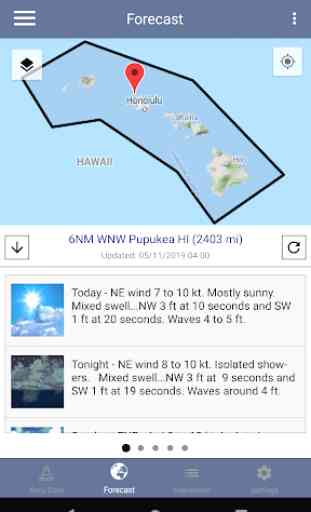
* 5-day National Weather Service marine weather forecast for point locations and weather zones
* Detailed NWS Forecast Discussion Reports
* Sunrise and Sunset times
* NOAA Severe Weather Reports
* NOAA HF Radar System for visualizing currents around many coastal US cities
* NEXRAD radar imagery and precipitation predictions
* GOES visibile, water vapor and infrared satellite imagery for the USA
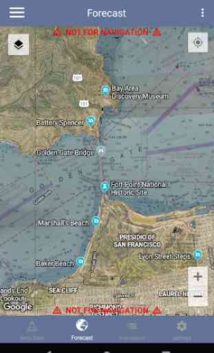
* NOAA Electronic Nautical Charts (ENC)
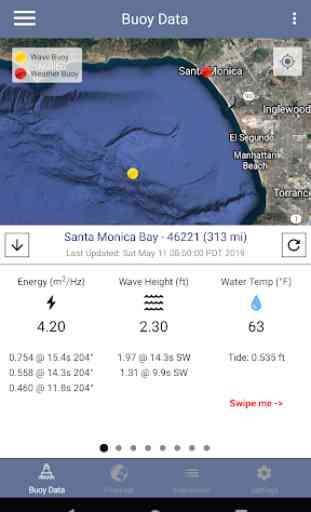
Real-time Data Includes:
- Primary and secondary swell height, period, direction
- Spectral wave energy density (wave energy vs period)
- Significant wave height
- Wind speed, gust and direction
- Air temperature
- Water temperature
- Pressure
- Sunrise/Sunset times
- Current NWS Alerts
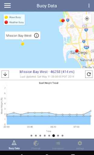
6-hour History Data Includes:
- Primary and secondary wave height, period, direction
- Wave energy, period, direction
7-day NOAA WaveWatch III Forecast Model Includes:
- Hourly swell component predictions (1-6 swells)
- Accurate wave height, period, direction predictions
7-day Hourly Harmonic Tide Forecast Includes:
- Interactive tide graphs
- Hourly tide predictions
- Current tide
48-hour Tidal Current Forecast Includes:
- Interactive graph to represent speed of the tide, in knots
- Hourly tidal current predictions
- Current tidal flow
5-day NWS Marine Forecast Includes:
- Text summary forecast
- Weather, sky, wind, waves
- Click any point on the map
Sunrise/Sunset Times Includes:
- Astronomical Twilight
- Nautical Twilight
- Civil Twilight
- Sunrise/Sunset
- Solar Noon
Real-time Radar and Satellite Imagery:
- HF Radar Real-time current flow velocity vectors
- HF Radar 12-hour averaged current flow velocity vector
- NEXRAD Composite Base Reflectivity
- NEXRAD Base Reflectivity
- NEXRAD Echo Tops EET
- HRRR Reflectivity Forecasts
- GOES North America, Hawaii and Alaska Visible
- GOES North America, Hawaii and Alaska Infrared
- GOES North America, Hawaii and Alaska Water Vapor
- Hybrid-Scan Reflectivity Composite
- 1-Hour Precipitation Forecast
- 24-Hour Precipitation Forecast
- 48-Hour Precipitation Forecast
- 72-Hour Precipitation Forecast
GIS Mapping System using realtime and near-realtime data from NOAA, including:
- NOAA Marine Zones
- NOAA HD Radar
- NEXRAD 4-bit Base Reflectivity
- NEXRAD 8-bit Base Reflectivity
- NEXRAD Echo Tops EET
- HRRR Reflectivity Forecasts
- MRMS Hybrid-Scan Reflectivity
- Long-Duration Hazards
- Short-Duration Watches & Warnings
- Significant Wave Height
- HF Radar Vectors (Surface Currents)
- Total Water Level (Tides + Surge)
- Tidal Water Level
- Water Level Surge
- Tropical Cyclone Track Forecasts
- Tropical Cyclone Best Track Analysis
- Wind Speed & Direction
- Wind Gust & Direction
- Severe Thunderstorm Outlook
- 15 minute Lightning Strike Density
- Surface Visibility
- Sea Surface Water Currents (w/ Speed)
- Total Cloud Cover (%)
- Air Temperature
- Sea Surface Temperature
- Relative Humidity
- Dew Point Temperature
- 12-hour rain probability
- 1/3/6/12/24/48/72 Hour Precipitation Accumulation
- GOES Northern Hemisphere Satellite Imagery
- National Grid
- Electronic Nautical Charts (ENC)
IMPORTANT!
Please remember that this app can only show data the buoy collects. Not all buoys collect weather data. Not all buoys collect wave data. This app will display all data collected by a buoy.
This app is primarily designed to focus on buoys that display the most complete package of marine weather data (waves, weather, forecast, tide etc).
If you notice a missing a buoy, please contact me first rather than leaving a poor review. If you are correct, the buoy can be easily be added to the cloud database.
Lastly, please feel free to contact me with questions, feedback, feature requests and bug reports at [email protected]
Category : Weather
Reviews (30)
Paid for the full version but 9x out of 10 it shows zero info from the wave buoys. Port Colborne for example shows -- in the app but when I use the rock the lake text phone number to get the buoy information it shows up fine which means the app is the problem not the buoy. Good idea and I like the look but it needs to be functional.
I liked it when I downloaded it, but, shortly after that, the servers at NBDC were shut down and the DART buoy data stopped being collected. Turns out, everything in my area seems to be from that network. So, I'm not getting enough data or forecasting.
Outstanding app! Real time buoy data, nearshore and offshore forcasts, a whole bunch of overlays like radar, wind, tide levels, sea height, cloud, rain, forcast,...and a lot more! It's worth the 2 bucks! I'm on Lake Erie, and she can change very quickly. This app is the best I have seen.
The Buoy Data Tide chart and Flood/Ebb charts need to better show the SPECIFIC times of high/low tides and flood/ebb, respectively. Right now you just have to kind of eyeball it. it would be nice to see the exact times of each. It would also be nice to customize the order of info displayed in the Buoy Data section.
I'm sorry but I need swell report like I've received from you since mid1980's when I started surfing nw. California. From Seaside to Santa Cruz. "NOAA" is deserving of 5 Stars because of their past performance. I would love the app. To give me all of the buoy swell data. Size, direction, per second intervals, and multiple buoys are needed for the accuracy of the time and place I will obtain best results of swell. The app. Has a great menu and format to set up easiest way to get Data. Swell?🌊
This app is pretty bad. I had one for a few years that gave the actual marine forecast word for word but it stopped for some reason. This app is a poor substitute. I don't recommend it for anyone that relies on good forecasts
it looks great at first but mostly interested in info you can get from NOAA marine radio stations. However, the info isn't divided into section like NOAA marine weather station. I want marine weather info for north Puget Sound & San Juan Islands and I can read that but when I scroll to the right it shows a completely different forecast, usually lots worse. which screen is correct? I have no way of knowing. Is it going to be calm winds and less than 1ft waves, or 25kt winds and 5ft seas?
Nice gathering of NOAA data displayed well, comparable to more expensive apps. Being able to enter, save, and name specific waypoints would be a nice add on.
Extremely useful tool if you go offshore. Real time data on wave height and period. Good predictions. Best part is tidal flow predicitions for timing passage through inlets.
I don't have a boat. But I do live in a house on the boardwalk in Long Beach, NY. Since I live along the east coast facing the Atlantic Ocean, I felt it was important to know what is going on over the water. I am in no way an expert, but I feel this app affords me access to marine information about my location, that I would be at a loss to have normally. So therefore I would recommend this app to expert and non-expert alike, for what a good job it does informing me about what I need to know.
App worked at one time but was extremely slow to load. After the last update it quit working completely now it's useless.
this app is okay. doesn't break down Puget Sound weather regions. there are several. just general Northwest forecast. can't change wind speed to knots. Just MPH that I can see.
Nice idea but many of the weather buoys don't show data. Not sure that's the app's fault, but still reduces usefulness
This is a fantastic way to access the marine forecast for a zone or point. But like others said, I can't see any buoys.
Very complete and usefull, plenty of information and fully customizable with access to almost all relevant data and forecast. Thank you Quantum for a job well done.
Pretty slow. Navigation is laggy and the zoom scaling is not worth this being a paid app
Works good big feature is being able to tap in an area and instantly get that report.
Absolute garbage 🗑️ app now. You get no weather information, radar, nothing.
My local buoy doesn't update. Now it is just another weather app. Paid $2 for nothing. Fish weather free app is better
couldnt get the app to work on my samsung note pad, kept crashing and wouldn't load data.
No weather forecast at all. Just a basic map showing where bouys are
Great app for determining when sea conditions are good for fishing.
To me this is a app that could save your life.I want to have the eariest posible weather reports.Thank You.
Easy to use and close to what is predicted waves
Great go-to app to get current conditions and forecasts.
Full time Fisherman Great App. Use it all the time
the best option I've found for fast marine forecasts since AccuWeather took their marine app away.
Very detailed and easy to use
This app has lots of good information but I wish the NOAA zone forecasts would follow the specific zones that NOAA uses.
Purchased this app to get data on n wave height, water temp etc. No buoys for the exact location I need. Closest is a few miles south but it's just a land buoy. This app is worthless to me since I can get the rest of the info I'm looking for free and Google can't refund it.