Norgeskart (Maps of Norway)
Now also with cultural history content from Norvegiana! Find out about interesting archaeological findings, cultural heritages, architecture, histories and more in your proximity.
This is a new and greatly enhanced version of our original Norgeskart app which has now been available for 5 years. Join more than 170.000 unique users and discover why Norgeskart has become so popular.
What was free in past versions of Norgeskart is still freely available, but the new app now contains additional paid content and functionality. We ask for your understanding that income is needed in order to further develop and maintain Norgeskart. By paying for a yearly subscription, you help us make Norgeskart reach its full potential.
Please visit www.avinet.no to see what we can do for you when it comes to developing mobile and web based map solutions. Our speciality is cost effective solutions for field registrations.
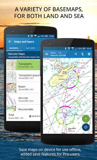
Free content:------------------
- Maps of Norway: Topographical and sea maps
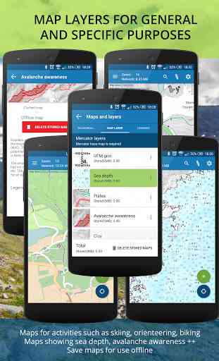
- Map layers for Norway: Avalanche awareness, ski pistes and sea depth
- Cultural history content from Norvegiana.
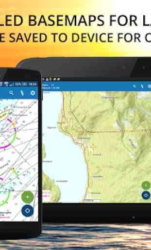
- Downloaded maps available offline for 2 weeks
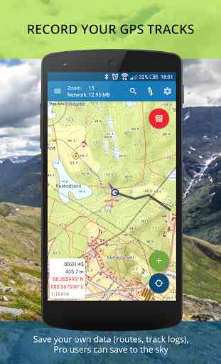
- GPS recording and 3 minutes GPS tail.
- Driving directions.
- Import of GPX.
- Details and graphs for recordings.
- Export of POIs and tracks to GPX.
- Retrieve exact height of POIs.
Pro subscription:------------------
- Offline maps available as long as you want
- Create manual routes
- Upload POIs, tracks and routes to map portal
- Access to map portal norgeskart.avinet.no
- Sync pois, tracks and routes across devices
- Clay, conservation areas, radon and snow depths layers
- Orienting maps from www.okartkiosken.no
Dynamic point subscription:------------------
- Connect to one or more dynamically updated KML files on the internet
- Tested against telespor.no for tracking sheeps
Known issues:------------
* If you have a Moto G or DROID MAXX 2 phone, you must upgrade from Android 6.0 as this version of the OS has a bug which crashes Norgeskart during zoom. This is not our fault.
* If you change the DPI of the device using adb you might experience tiling problems in the map. You must then reset your changes by using "adb shell wm density reset" from PC.
* We uses several external map services. These can at times be slow.
* People that do not find Norgeskart in Play store should check that their content filter is not set to "Everyone". It must at least be set to "low maturity".
* There is a limit of 10.000 tiles per day per IP-address which is handled by the servers of the Norwegian Mapping Authorities. Other people on the same wireless network might therefore spend the limit.
Category : Travel & Local
Reviews (27)
The app is amazing and can practically replace a standalone GPS as long as you carry a battery pack for your device. The amount of free features in this app is astounding and the subscription, which you only really need if you need offline maps, is really affordable.
Almost perfect for hiking. Except for download speed for tiles. Speed is ~12-20 KB/s while using 1Gb/s wifi. It could be better. [edit] Yes, download always resumes and does not break if you do not need to log in to wifi via browser.
1. Premium subscription works only with Norwegian Google accounts (you have to change it if you want to use offline maps) 2. Map downloading is very slow. But you can change zoom level to download.
Excellent app! Really detailed and easy to use. If you have an account you can upload your POIs and sync to other devices. Support excellent. Recommended!
Offline maps very buggy, sometimes they render, sometimes not. Zooming out+in sometimes helps, sometimes not. (Loaded all zoom levels offline)
The most adaptable hiking map for Norway with several unique map-layers like mtb-map (open street), avalanche and others that can be combined.
Quite useful for the Norwegian outdoors. Height information is specially useful and cellphone coverage impressed me so it really was convenient all around
Good and stable app. I dont bother bringing my garmin to hikes anymore. This is far better and very easy to use!
Looks good but I cannot order your subscription. I registered Google account as norwegian, have entered Norwegian dnb card as a payment card.
The offline map is no longer free so the whole description of the app is now a lie
really dont understand ..everything in pro .
when i am downloading tiles, it seems to stop if i lock screen or put the app in the background, how do i keep it going?
Eats too much battery to be used outdoors.
If what you want is a good map of Norway, this app is great. It makes available huge detail and has good GPS support (provided your Android device can get a decent satellite fix).
Works great, even with the free version. Have used it instead of paper maps for several years around Norway. :)
Gps does not work. And neither does the offline mode, this is a hoax
Nice map for travelling and hiking in Norway.
Its always update the app to connect to my other two gmail acc. Then offer to delet the points i have set before. This acc where he write 'cant purchase' i had this bug 2. The purchase is not awailable for some of the phones. Most up to android5. Its not a good thing, but u can always borow friends phone to make purchase, just log in with your acc and make purchase, after delete your acc data from the phone. Your purchase will go to gmail acc. After- you will still need to reinstal and delete all points u have set in. And pls avoid connecting to gmail with other google acc because u will lose all points again.
This is a great app, but there is still much room for improvement. For starters, names if the places om the map is just way too small to be readable and should be bigger, at least for smartphones.
this app is very useful for me :-)
The app works well, very nicely detailed maps, good for hunting and setting waypoints. However having a little problem with the size of the text on the map it's far too small. In the settings I've changed it to large but it's still tiny.
Cannot buy premium, its showing somthing about whaiting for subscription and not alowing to pay... Or premium not awailable anymore?
Great App and lots of functionality. I am in the mountains all the time and this app is great for route planning and following snowpack trends. Also good environmental and archeological data on here. One MAJOR FRUSTRATION for me - when I create a route and export as a gpx file there is zero data in the file 😞....... Wow thanks for speedy reply. I encounter the problem on the phone app in the newest version of android, which I think they call nougat. Look forward to the fix. F
Still takes forever to load maps for offline use. And it doesn't support background downloading, so I have to constantly keep the screen on for 10-15 minutes for the map to download. 40 seconds pr MB. Except for this, this is a great and must have app.
Offline function worked great once I looked where I needed to go in advance with a connection. Very detailed and the current position really useful. Thanks!
Excellent maps but poor Legends. The only legend avail is for skiers, none for road/trail users. For example a gravel road that is yellow in color, what does the color yellow represent? A Legend would be helpful for planning my vacation. The lack of proper legends is holding me back from buying a subscription.
Like many Scottish hillusers I am looking for a replacement for Viewranger which closes Feb2022 to be replaced by the less capable Outdooractive. If you wanted to add functions and expand to a neighbouring territory, now's the moment!