nv charts
nv charts intuitive boating navigation app provides dynamic navigation experience using a large toolset of nautical boating navigation tools, lost of features and seamless chart display so you can navigate safely and enjoy nv charts‘ superior up-to-date cartography and geocontent on your boating adventure. All your nv charts can easily be downloaded and saved on the device enabling full offline support when out on the water enjoying your time. All your nv charts / NV Verlag nautical charts covering boating in the Nordsee | Baltic | German Inland waters | Netherlands | Waddensea | Ijsselmeer | Sweden | Danmark | Germany | Norway | France | USA |Caribbean | Cuba | Bahamas are compatible with the nv charts app.
NV Charts data are constantly updated, most detailed and reliable boating app, and with nautical charts available even offline. Plus, the nv charts app will be continuously developed and updated for you.
### nv charts App · features:
- Offline navigation
- Reads / accesses all nv charts
- Simple download of charts
- Data is always up-to-date
- Synchronized navigation with other mobile units
- Seamless zoom and panning functions
- Intuitive route planning
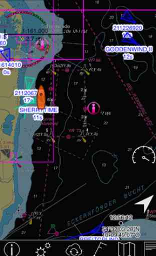
- AIS Wifi Support
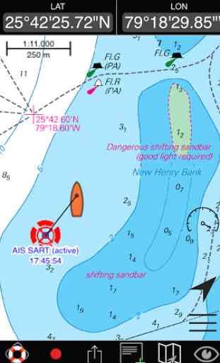
- AIS Sart Beacon
- AIS Wifi Support
- AIS Sart Beacon
- Pro night mode
- Tracking and logbook, Marker, Ruller
- Positioning with both GPS and cellular signals
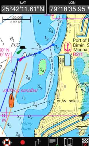
- Harbor Pilot · NV. Pedia
- Lighthouse sketches
- Dashboard of instruments
- Online weather
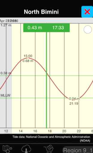
- Tide prediction
- Improved menu structure
- higher resolution setting available
- Search near me – all information around your location
- Position-sharing and Route sharing
## Android version 5.1 or higher is recomended## Night mode will only be supportet on Android Version 5.0 +## Enhanced rendering will only supportet on Android Version 5.0+## NMEA log will only supportet on Android 4.4+## Audio Alarm (SART, Lines, Circles ) will only supportet on Android 4.4+
Note:
Continued use of GPS running in the background can dramatically decrease battery life.
Category : Sports
Reviews (28)
At best, the app shows the charts you have purchased (one by one). Syncing of routes and markers between various devices (iOS, Android and MacOS), a rather basic function, does not work... Hilarious that now the app has augmentic reality: they are trying to run before they can walk.... Question is of course if it is even feasible for NVCharts to make a decent digital app: the charts can only be displayed one by one in the app. Basic architecture seems wrong...
The app is quite well designed and practical. The maps are very good, easy to follow, and clear. However some regions seem to have a lower resolution than others and one cannot choose the symbol (nor its size) for the boat on the map. Support is excellent.
The app was working happily and I had created a number of routes logbooks and waypoints, which have now disappeared. Update:Tech support sent a patch which has fixed the issue and a further update has added to the app. It would be great to export log book files as gpx files with speed etc
After the last update it doesn't load online charts at all, it doesn't show my outdated charts I've bought earlier. After each update the app gets new functions and becomes more useless. It seems the time to uninstall it.
Perfect for easy and inexpensive coastal navigation. Super clear charts in large book form, with app for use on most devices (mine run android). Garmin and Raymarine must be worried.
Pretty lousy. Map resolution in close approaches falls behind Navionics. Overview when out of Pixel maps is a joke. There you're better off with Google Maps. Just wasted 50EUR on a Croatia map just to figure this out.
Add chart with id does not work. Empty "My Chart" page appears without option to download the chart.
Up to date raster maps, with AIS layer
This is a friendly system, it is user friendly.
Very handy app for leisure navigation
Useless App
Besides what it can do in terms of navigation, it continuously sends my position to the nv servers AND makes it puplicly available to all other users without any option to opt out from this. It's hard to believe that developers are still that stupid/naive... Just look at Strava or Polar to see what happens when all best practices for privacy are ignored.
It's a good app so far and works well with the charts which were my first buy. Bettered by Navionics as there are still some rough edges in usage but great as a backup for a plotter.
I bought the paper charts and this came for free. I wrote my own app using Google charts as the other apps were rubush but this does pretty much all I wanted. It would be nice to access the tidal data for routing but it's a good start.
Great app which came free with a chart, its usefulness has really surprised me.
This app used to be really good also use the full pc version. But now can't download charts as password page doesn't work on new tablet. This is potentially disastrous as I use the tablet most of the time for electronic navigation. Still like the NV paper charts but now lost confidence in NV app. Is this a common problem?
Keeps telling me invalid serial even though I spent 228 Euros
The charts work well on my galaxy S5 good on the boat
Unable to give it any real stars as I was unable to find any north american charts to use. Seems mainly limited to Europe and South American. Am unlikely to even set up an account unless I can see what's available in my areas of interest. Also get blank web page when visiting them on occasion too.
Nv charts is an advanced charting instrument used by mariners to bring their ship from one port to another port in easy and accurate way .
This app has a nice interface! Simple to use,and easy to understand and use. Map display supports pinch-to-zoom! I'd like to see the ability to import U.S. NOAA Raster (BSB) and Vector (ENC) Charts, which are free to download from the NOAA web site. Doesn't seem to have Great Lakes coverage for Michigan available in the store. Would like to see more regular chart formats supported.
It's nice but sad to say I can't buy a small scale map
Doesn't work. Word from company is they think they will fix it. Came with paper charts and says it works on apple, windows and android... No version for apple OS X and android app won't bring up purchased region.
You get the free app but can't do s#it until after you buy charts for it! Utter rubbish
Wants email Addy b4 it does anything .... To suss 4 me
i loved it
The new version constantly crashes my phone and tablet. I used to use to document my trips. This is going in the trash and I will buy a real tool. So sad, it was ok. I used to recommend to all. Now I tell everyone of its problems and warn them to stay away. Don't waste your time.
The app is great. It definitely makes route planning easy, and fun. The customer support that accompanies the app is bar none. We had a slight issue loading the charts onto my phone and Jessica at NV stepped in and fixed the problem very quickly. Thank you!