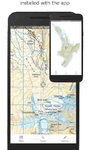
NZ Topo50 Offline Sth Island Map and Hunting Areas
Ideal for back country navigation without cell phone access. Popular with trampers, walkers, bikers, runners, hunters, SARS, Te Araroa walkers.
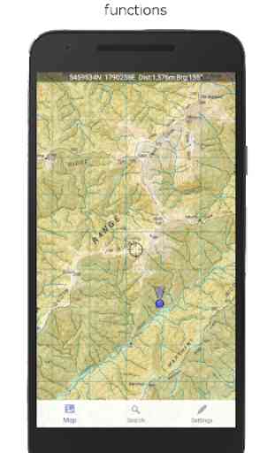
Navigation functions includes GPS positioning, track logging, user waypoints, orientation (compass), altitude and speed display, and distance and bearing to points on the map. Search for and zoom to named places and features on the map. Tracks and waypoints can be imported, exported, and shared in kml format.
Te Araroa walkers: Check our Facebook page for a link to import all of the Te Araroa track sections into the app.
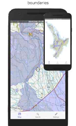
Hunters: An overlay showing DOC open permit hunting boundaries is included. This shows all current permit boundaries in detail so you can determine where you are in relation to the boundaries as you go.
This app is built from the ground up to use the NZ national map grid, not the global average WGS84 datum commonly used which distorts the map. This is easy to spot. A true NZ grid will give you perfectly parallel gridlines when the LINZ map is projected onto it.
No internet or cellular phone connection is needed for full use of all the maps and navigation functions.
The storage space required for this app is reasonably large. Ensure you have sufficient space available.
Made in NZ.
Category : Maps & Navigation
Reviews (22)
Works fine on tablet under partners log on. Used to work fine on my log on but now says "there was an error locating the map files. Save a copy of your wavepoints and try re-insalatin". No longer works under my log on. So I just use partners log on. Stupid really, as it was ok.
Excellent, true to description and very reliable. Bearing and distance function very helpful. Having NZ Gazetter names makes it easy to locate places of interest.
This has to be one of the best apps I have. It worked perfectly every time I used it recently in the most remote places and no reception, Awesome.
Really enjoy this app, and the Northisland version, Any chance you could add a zoom for the big scale? Trying to zoom at one scale and it jumps down a scale, then the writing I was zooming to see got smaller haha! Would be good to maybe have a button to push and that will change scales, or something along those lines Otherwise! Wicked app, keep up the good stuff Cheers
Super handy app I have been using this instead of a GPS for hunting. Seems very accurate I find the DOC hunting block boundrys very useful particularly in the molesworth and Stewart island where the blocks are small and difficult to identify. Also very handy how you can add points for marking animal sightings camps ect. One feature I would like to see if possible would be the ability to see/download a Google earth/satellite image overlay to certain chosen parts of the map. To aid planning.
Super easy to use, awesome dev support. This app has saved me some major headaches when the clouds have moved in.
Does what it says, could do with some interface improvements and would benefit from better import / export options. Like to see better integration with other map products (Google KML files?) But overall pretty good.
Awesome when it's working but at the moment it's not picking up satellites. Is there a glitch in the system
Thanks for the tip re the back button. Any way to hide all waypoints but show only user waypoints in the list
This was my most loved app during a year of traveling in NZ. Used it for many many backcountry adventures, both to plan and navigate. Easy to use and no issues. Highly recommend to anyone getting outdoors on the South Island!
This was a great app, very user friendly. UNFORTUNATELY it doesn't work after a recent update! Won't download properly, or reinstall. The map remains low res. Hope you can sort this as I miss planning trips on my lunch break! Thanks
Super helpful and it was a great backup for my paper maps while I was visiting and it was great for checks of my position when I didn't feel like hauling out everything. It was also great for planning.
Not good. Route was intermittent and mostly showed in straight lines as the crow flies. Another who downloaded the map had the route stopping and starting. I'm afraid this app is a waste of time and money.
I have used this app extensively. It's a great app that seamlessly compliments my NZ topo50 paper maps. Great that it also works in offline mode, especially when in the backcountry with no cell coverage. Love it, worth every cent.
Unable to install unless you have over 1GB free space on your phone's memory (for the app!). Hard for slightly older smartphones. Would be good to have the option to install just the app program first then select to download the map files to SD card...like every other topo app
I really like this app. A lot of issues people have with apps like this, including me! Are from not understanding how they work. Once you get the hang of it this is the best one I've used. Support is very good too. I use for 4x4ing. It is excellent!
A pretty handy offline map for hunting. Would be nice if there was a way to import your own area overlays, as the DOC hunting area overlays only has the open areas and I'd like to have my roar block displayed. I've tried creating an .kml format area of it but it fails the import.
Useless can't close the app at all have to restart phone to use any other app or feature. Have tried back and the settings , app takes up the entire screen can't get out if it without restarting phone. Samsung s20
Great for hunting. I use this in conjunction with a PLB and it negates needing expensive GPS. Would not RELY on for emergency but definitely accurate enough if you had no choice.
Does exactly what youd expect. Has good quality, very detailed topographical maps for the entire south island, with a good built in tracker and useful overlays
Love the maps and all that only issue i have is it regularly tells me maps gave to be downloaded all the time. Pain when you get out and map doesn't work properly, can you sort it plz
Uses about 2GB of storage (just for the South Island maps). If you have the spare space on your phone then this is nicer to use than apps that allow you to manage offline downloads of maps manually. The interface is nice and simple to use, personally I prefer this app to BackCountry Navigator. Unfortunately this app forces itself to fullscreen and has no option to disable this. This makes it difficult to switch apps if your phone doesn't have physical buttons.