OFFROAD ATLAS
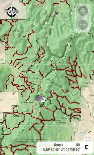
What is a MVUM? It is a map that shows where you can legally operate a motor vehicle on National Forest land. OFFROAD ATLAS uses your phone’s GPS to show your location on our seamless map. We combine the MVUM with other data such as local roads and our map is easily downloaded for offline use.
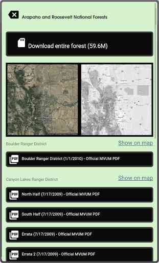
You may browse the map while you have wifi or cell service and OFFROAD ATLAS will automatically download any of the areas you view for offline use when you don't have network access. You may also bulk download any of the areas you plan on visiting.
Always have as much information as possible, please consult the published (printable) PDF Motor Vehicle Use Maps available for any individual forests you plan on visiting to get the latest dispersed camping allowances, seasonal closures, and any other relevant information. As always, be careful, many trails and roads are not suitable for passenger car travel. Some are only traversable in the most capable off road vehicles by the most experienced drivers.
Have fun, be safe, and respect the trails.
Have another favorite Android mapping app but want to use the OFFROAD ATLAS Motor Vehicle Use Map? You're in luck!
OFFROAD ATLAS stores its data in the rmaps sqlitedb format that you can use with another mapping app that can handle rmaps data, such as Maverick: GPS Navigation.See offroadatlas.org for details.
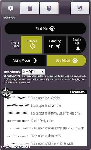
Night Mode available only on Android KitKat (4.4) and later devices.
OFFROAD ATLAS makes no warranty, expressed or implied, including the warranties of merchantability and fitness for a particular purpose, nor assumes any legal liability or responsibility for the accuracy, reliability, completeness or utility of these geospatial data, or for the improper or incorrect use of these geospatial data. These geospatial data and related maps or graphics are not legal documents and are not intended to be used as such. The data and maps may not be used to determine title, ownership, legal descriptions or boundaries, legal jurisdiction, or restrictions that may be in place on either public or private land. Natural hazards may or may not be depicted on the data and maps, and land users should exercise due caution. The data are dynamic and may change over time. The user is responsible to verify the limitations of the geospatial data and to use the data accordingly.
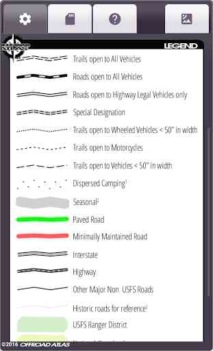
The map service depicts Forest Service roads and trails that are designated for motor vehicle use under the official U.S. Government Code of Federal Regulations for identifying designated roads and trails (36 CFR 212.56). Road and Trail MVUM. Additional roads, such as highways, county roads or public roads, are included for mapping purposes. This map service shows the specific types of motorized vehicles allowed on the designated routes and seasonal designation. Data used in this map service are designed to be consistent with the MVUM (Motor Vehicle Use Map). The road and trail data are compiled from the GIS Data Dictionary data and Infra tabular data that the U.S. Forest Service administrative units have prepared for the creation of their MVUMs. This data is published and refreshed on a unit by unit basis as needed and approved by the individual units in order to stay in sync and consistent with the published MVUMs. Interstate, Highway, Other Major Non USFS Roads, and Historic roads for reference are for mapping purposes only and should not be relied upon for their availability for motorized use.
U.S. Geological Survey National Hydrography Dataset, U.S. Department of Transportation Federal Highway Administration HPMS, and various USDA Forest Service datasets used in compiling this information.
Category : Maps & Navigation
Reviews (16)
Don't bother.....
Great idea and execution to make MVUMs easy to use. However, it seems all of the MVUMs are outdated so the app doesn't serve any purpose. It would also be nice to have some sort of in app file management to see what is already downloaded and what is pending, plus the ability to delete or update specific maps and/or regions.
Pretty awseome app. One suggestion. Please make it linkable to a family members phone so they can see where im at if something happens. An emergency butten would be cool too that sends a message to the other phone
Its ok.
Love the app and it's just what I've been looking for. Still only has 2016 maps. Update: Still only has the 2016 maps. New updates has new maps but the year is still showing 2016 on the maps.
I use it regularly hitting trails in the Francis Marion National Forest minimally maintained and non maintained roads. Some are hardly visible and this GPS works great for finding them and identifying which are non or minimally maintained. Two thumbs up
Been looking for something to guide me on local forest roads. Works great on my Galaxy S7 Edge. Used it this afternoon for hours of back roads riding in the forest. Thumbs up on this great app. Question for developer: Any way to flag an area you encounter on the trail? Would love to see it on the map for future reference or going back to later. Sammy
UPDATE: I did see the update and just got a chance to attempt to duplicate the issue of previous version. Bravo! Good Job ... or MDPI ... not sure, but works as expected. Nice.
BSJ. On board. Love it.. works great. I need a cut in this... I've told 5 people about this app.. in 7 days.. and all have bought it! ;)
Would not load all the State Hwy's and not any of the County Rds or trails
They idea of pre-planning a route, with good chance for a successful trip is greatly improved with this app. Very competent and useful information based on mvums that are as up to date as possible. With the app and a phone call to the ranger station(s) for confirmation before leaving, it's as close to an "easy" button as it gets. Very nice!
Great MVUM app for Jeeping! Works great with Backcountry Navigator as well. If you're the Trail Leader for your Jeep Club trip or if you're going out exploring on your own, you NEED this app! And in the off chance your phone has a technical problem, the developer is readily available to help you troubleshoot the problem. Offroad Atlas should be on every outdoor adventurer's phone!
The best tool for finding access to the National Forest I have found.
If you off-road you want this!
The poor resolution makes these maps painful to look at. Don't know where the refund button went but I so want my 99 cents back.
Only covers a little bit lots of map missing