OpenCPN
- now available on your Android mobile phone or tablet. See below for support links!
NOTE: The current version requires a decent phone or tablet with an ARM processor. It might crash on tablets with an Intel Atom CPU.
FEATURES:
* IHO S52 compliant display of worldwide S57 and S63 vector charts.
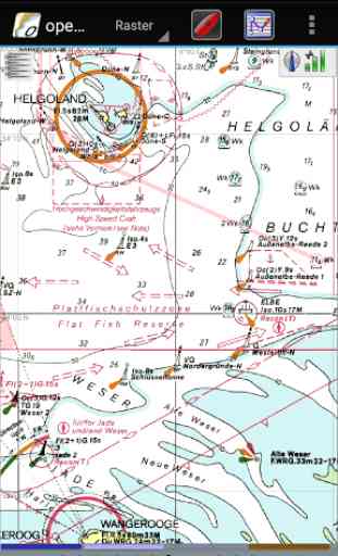
* BSB v3, and earlier, raster chart support.
* BSB4 and "nv-chart" support through plugins.
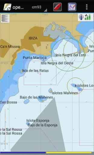
* CM93 vector chart support, with per cell offset corrections.
* Single-chart and Quilted display modes.
* North-up, Course-up and Chart-up display modes.
* Moving-map display mode.
* Route navigation with ship tracking functions.
* Waypoint navigation.
* Dashboard, for configurable on-screen display of ship's NMEA data.
* NMEA 0183 GPS interface at selectable baud rate.
* Advanced NMEA message handling structure with built in multiplexer.
* Autopilot output support.
* AIS input with full target tracking and collision alerting.
* AIS support for SART / automatic MOB handling.
* AIS support for DSC and GPSGate Buddies.
* Anchor watch/alarm functions.
* GRIB file input and display for weather forecasting.
* GPX Waypoint, Track and Route input and output file support.
* Tide and Current prediction and display by location.
* Route planning with tidal support.
* Builtin great-circle routing.
* Weather routing through qtVlm or separate plugin
* GPX Layers for annotation of charts.
* Climatology and Weather Fax,
* World Magnetic Variation
* 20+ languages supported
* OpenGL support for enhanced performance
* Windows, Apple OS X, Linux and Android applications
COMMUNITY SUPPORT: http://cruisersforum.com/forums/f134/ (English/International) http://opencpn.org/ (English/International) http://opencpn.de/ (Deutsch) http://opencpnayudaes.yolasite.com/ (Español) http://plaisance-pratique.com/-opencpn
- (Français) http://opencpn.shoreline.fr/ (Français) http://opencpn.no/ (Norge)
ANDROID BETA TESTING PROGRAM: https://goo.gl/WEUtbx
BUG REPORTS & FEATURE REQUESTS: http://willkamp.com/opencpn/flyspray/
APKs & SOURCE CODE: http://bit.ly/opencpn-android https://github.com/OpenCPN/OpenCPN
SOCIAL MEDIA: https://www.facebook.com/OpenCPN
This program is free software; you can redistribute it and/or modify it under the terms of the GNU General Public License as published by the Free Software Foundation. This program is distributed in the hope that it will be useful, but WITHOUT ANY WARRANTY; without even the implied warranty of MERCHANTABILITY or FITNESS FOR A PARTICULAR PURPOSE.
Category : Maps & Navigation
Reviews (28)
The soft looks ok, not a great design but people seems really amaze by it. I would certainly if I could understand how to use it. Where is the tutorial to explain how??? Spending a week trying to get a weather fax from my lap top and it never worked. So many function to set but don’t know what they are for. Very poor VDO of user on Utube to explain how it works. Where can I learn how to use it??? I need a weather fax and chart plotter. I am struggling for days and days trying to understand.
l have opencpn on my macbook air. Nice program, I'm still learning it though. This free android version is garbage. I don't understand why it is even available. It comes with the chart downloader plugin installed but it is broken. Most of the icons are missing or inoperable. If your not willing to buy the paid version for testing don't waste your time with this free android version, you will be disappointed.
I have spent days trying to download a chart and got nowhere. I have found some charts, but can't get the program to read them. this has to be one of the least intuitive programs I have ever used. it looks like it would be good if only I could get started. so I will persevere. I hope I can find a tutorial.
This is one of my favorite apps, its not comoatible with all of my devices, but thats ok, it works on the ones I need it to. Having a free chart plotter thats better than my rather expensive GPS is awesome, however that says a lot about Garmins quality and not much of it good. Thank you to all of the devlopers who have worked on this to make it one of the best navigation tools I have.
This app has some short coming but it is good for navigation, Took us from Lake Ontario to Florida on my Xperia table without main issues, the window version is more versitile and I used it for planning and backup navigation. Kudos to the developer. Thank you!
The app works, but is pretty clunky. I had to download the maps from openseamap to my computer and then copy them to the Android device via USB. This works usually. except when it crashes, but is this seriously the best we can do?
Don't waste your time. This app has a seriously broken UI. Unable to load charts. Much of the preference/settings dialogs are mis-sized for a phone screen. Chart loader doesn't recognize pre-existing chart folders.
Clunky, slow, hard to find settings. Can't figure out how to change depth from meters to feet. I've been using and writing software for over 40 yrs, can't figure this app out. Poorly designed.
O-charts plugin does not appear to work with this app (although it supposed to work with PC version) therefore no Canadian maps available. Gave it 3 stars as it is amazing that this is a free app which deserves to Kudos to it's creators. I'm playing around with a Rasp Pi AIS.
This is really not user friendly. Unable to download maps for UK and European waters. There is no help to show you how. Navionics or CMap is far better and easier to use.
This is an excellent app that is ported from PC open source software. Unfortunately it has not been updated for 6 years for Android unlike the ports for Windows, Linux, Mac even the raspberry pi. At the moment it is better to look at something else.
Charts don't load on pixel 3 or 4xl. Charts works great on my galaxy 8s. I wish the charts would load. Love the app outside of that. Apparently the app is designed for an older version of Android
If you want to display different chart types and know where to get them this is the app for you. If updating chart catalogues in the file system is too much for you you'll probably be safer and happier with a paid app.
This app is useless for people outside america as it is nearly imposible to install charts for other areas. In my case i can buy charts for ireland but i canot install them on the android version.
Great app. Have it installed on my Windows PC, 3 Raspberry Pi's and 3 Android phones. This is the best marine plotter program available. For the phone get the offered pay app, pay only once a few bucks.
took some time and learning curve to get set up but great results as chart plotter. better than Raymarine on my boat except cant run autopilot. installed on samsung s7.
App keeps stopping. Reinstalled & uninstalled 2x. Changed scale to see buoys, nav aids larger & app fails. Waste of time. App does not work... unreliable.
One of my Best apps, I got a Chart of my island from a tourist came on a yacht and it works been using it got plenty fishing ground now WOW... And the chart was the World Charts, well lucky me I can sail anywhere and its offline too and uses GPS. Thank u very much...God Bless u All. Stay safe from Covid-19.
Great to use for voyage planning. Have used it on friends boats and would really like a way to send saved routes from phone to PC. THANKS
How do I load/add more precise charts to this app? The one it comes with shows nothing but outer boarders of continents and islands and I can't find anything to download a proper chart for my region.
Very good apps and useful. Hope to learn how to download map for Micronesia and the other countries.
Lots of good features, but usability (eg on a phone) could be improved.
This version does not work on Samsung S9+ with Android 10. Works well on Windows 10.
Charts won't load and app crashes.
Awesome just the same as the one I use on the laptop used to use navionics but it became too complicated and expensive
Fantastic alternative to Garmin, Raymarine, and B&G chart plotting systems! Wonderful and helpful community comes free of charge with the app through the forums!
Awesome on my laptop but via mobile a pain for satellite view (cant find how) and route making is difficult/ not doable
The most useful navigation app bar none. Does it all, and does it well. Chart plotter, AiS, NMEA data.... Prefers a big screen and a powerful processor, so I tend to use OpenCPN on my laptop rather than on my smartphone, but sometimes, being able to take a waterproof smartphone into the cockpit with a chart plotter or an AIS transponder running on it is most welcome. Steep learning curve but will repay the time you spent learning it.