OruxMaps Donate
Map viewer, track logger.You can use OruxMaps for your outdoor activities (running, treking, mountain bike, paragliding, flying, nautic sports,....)
100% free100% no adversisements
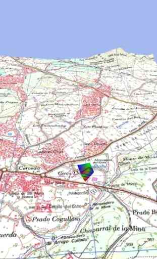
Online and offline maps. Support to multiple formats:-OruxMaps format. You can use maps from Ozi Explorer transformed wit a PC tool.-.ozf2-.img garmin (vectorial) -no full support is provided-.-.mbtiles-.rmap-.map (vectorial from mapsforge). Support to custom themes similat than Locus themes.Support to Wms, you can use the application as a WMS viewer.3D view.Support to multiple external devices:-GPS bluetooth.-Heart rate monitors, bluetooth Zephyr, Polar (including bluettoh smart devices, like polar H7).-ANT+ (speed, cadence, heart rate, distance,...).-AIS information systems (experimental), for nautical sports, using Wifi o BT.More features:Support to KML KMZ and GPX formats.
Share your position with your friends, display the position of your friends in your device.
Download online maps for offline use.
Text to speech support.
Profiles; save your preferences in your SD card.
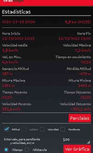
Statistics with graphics.
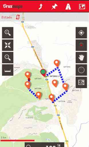
Follow routes, with different alarms to alert you if you are near a waypoint, or you are far from the route.
Create/save wayponits, attaching photo/audio/video extensions.
Custom waypoints types, with your icons.
Basic support to Geocaching.
Correct the altitude of your tracks/routes using DEM files (offline) or online services.
Search/download tracks from:-everytrail.com-gpsies.comSearch or create tracks using online services from Cloudmade or offline using Broute app.
Upload tracks to:-mapmytracks.com-trainingstagebuch.org-ikimap-wikirutas-openxplora
Live tracking using:-mapmytracks.com-okmap application-gpsgate protocol
More info here: www.oruxmaps.com
Category : Travel & Local
Reviews (18)
Oruxmaps is very sophisticated when it comes to various settings, interfaces etc., route creation is easy but it is missing one fundamental thing to help with navigation .. an arrow pointing to towards your route if you stray off it, yes it has a directional arrow showing your current orientation and position, & it has alarms if you stray a preset distance from the route, but i want a large semi-translucent arrow to guide you towards and in the direction of the route, see how MMtracker does it
I've been using OruxMaps for a few years now since beta, and now I have paid for OruxMaps GP because I like how much effort the developer has put into this app. I use it for hiking and off road motorcycling. One MAJOR thing that I have not been able to figure out is how to get CONTOUR LINES to display. The map file of British Columbia that I use is downloaded from Mapsforge. Can the developer please help me? Thanks!
Great app! Takes a bit of time to get used to, but its time well worth spending in my opinion. The app has plenty of settings to play with and customize the experience for many different uses. I use this app when im doing adventure-riding with motorcycle, works great for that. Ability to use offline maps is a must when mobile signal is not guaranteed. Route planning feature could be more refined. At the moment use topoGPS app for planning and oruxmaps with offline map for the navigation.
Simply awesome! There is a bit of a learning curve, but that's is only because it is packed with features! It will transform you smartphone in a device as capable as any commercial GNSS device. My use case: transformed an old smartphone in a pretty powerful bike computer and hiking gps. =)
Latest update includes new permission (Google Play Billing) not explained in change log. App does everything, developer very helpful and responsive to problems. The app can be a bit daunting to use due to its complexity, but persistence is rewarded. Edit 30/3/20 billing permission is still there...
Excellent map app. Incredible how many maps can be loaded into this. It's not the easiest app, but for anybody who can read the manual it won't be a problem to use. And it's worth it, best hiking map tool I ever used! (And I tried many)
Very happy with this app, power consumption is great, most importantly it plays well with some OSM based Garmin maps I like to use. The UI is very customisable so I was able to simplify the UI to have the elements I want right at the fore. Thanks for making this!
Developer DESERVES Our Support. Developer is VERY reliable & TIME-PROVEN! As a first time EVER paid subscriber on Play, OruxMaps is worth it: COMPREHENSIVE Great App that once you take the time to learn how to use it will enhance your experience & one less thing to be concerned about. I'm too busy/old with pedaling to push my 70+ lb heavy "Survival E-Tank" (slime-filled inner tubes, Mr. Tuffy 4" tire-liners, side-saddled heavy mountain e-bike) to worry about failure using an inferior Map app.
If I could I would give this app 10 stars as in my opinion it's twice as good as any other app i use and I do have quite a lot. I have the paid for version and i paid simply because it is that good and to use it for free actually made me feel guilty. It takes time to understand it fully because it is so comprehensive. I use maps provided by talkytoaster. Take your time with the manual and use the settings to make it right for you. Thanks to the creators of this app.
Best mapping app I've ever used. Create maps on your desktop and download or download maps right in the app. Supports gpx, kml, kmz, and more. Reads geo tagged pdf maps. Takes a while to learn, but that's because it's so flexible and comprehensive.
As a walker/hiker it's the most used app on my phone. Yes, it takes a bit of getting in to to use it...but well worth the investment in time (and money). If only Ordnance Survey could work some way of working with Orux....
It keeps losing the maps I load in and now I cant get them to load at all. Its extremely annoying to have a route planned and then have it vanquish while in the middle of nowhere. And simply adding them back again is an absolute pain when the app cant even find them half the time.
This has to be the best app for navigating. With an .img map installed from talkytoaster (Not Garmin) I feel totally confident of trecking anywhere without getting lost. I can't praise this App enough. Take time to understand all of the fantastic features here. You won't regret it.
I've used and recommended this app for years. I've even made a donation. Recently my 7.0.2 stopped displaying vector maps on my samsung tablet. Finally found a post that users needed to update to GP version for new versions of Android. So I thought okay, I'll pay the $5.49. What I didn't realize was that you were going to charge me the same again to put it on my phone. Tacky practice that I've never encountered before. Shame on you.
Fantastic. Use this for hiking. It's also the only way I know to get TalkyToaster maps into Android. Options are blooming confusing until you get used to it! But time & effort most certainly ARE rewarded.
I am a retired expat living in San Felipe Baja MX, our off road club (Scorpions) almost exclusively use this application for navigating Baja. This app features are extremely user friendly, our club has a default setup that is shared by our club members which allows us to easily navigate the app and share data. Our club also has a standard file folder construct for storing routes for local and multiple day runs. I could not be more pleased with this application.
1000 knobs and no working search feature. Unintuitive. Feels like it maybe needs a 3-4 hour video course to learn to _start_ using. I suspect it is really targeted for dedicated technical hikers. Oddly enough it makes me want to just buy a map and grab my compass.
Hello, i am an officer in defence force of India. We use your orixmaps for creating ops plans and navigation. I must appreciate, the simplicity and functions that you have provided. There are numerous types of add ons in your app. We have also added oruxmaps in our study curriculum so as to teach new recruits about orux. Thanks for giving this kind of great app. I request you to kindly add demo type video to show how to use multitracking on YouTube or anywhere. Thanks