OS Locate
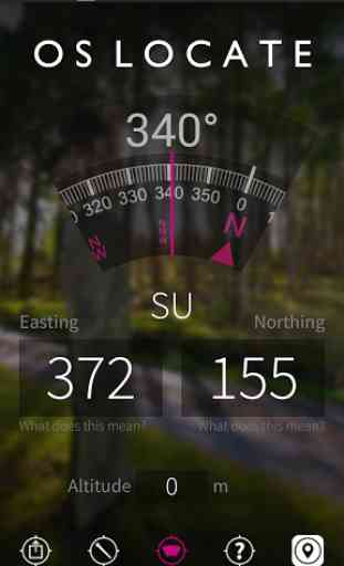
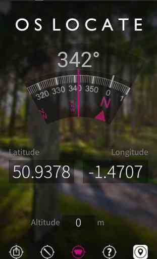
The app converts GPS location readings from your mobile phone to Ordnance Survey National Grid references, enabling you to determine precisely where you are on an Ordnance Survey map. No mobile signal? No problem; OS Locate does not require a mobile signal to function – the inbuilt GPS system can be relied upon, even in the most remote areas.
Simply download the app and switch on your device’s location services (Settings – Privacy – Location services).
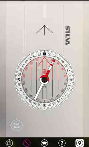
Compass accuracy: the app relies on your device's internal compass and if this is inaccurate the displayed compass will be incorrect as well. Accuracy generally increases the longer you have the app open and many users report moving the device in a figure-eight help calibrate the compass and gives a more accurate reading. Of course, like any compass, keep away from metallic or magnetic objects!
OS Locate is packed with additional features. The ‘Share’ button allows you to connect with friends and family via messaging and social media – let them know where you are, how your adventure is progressing and what time you will be home. Use the handy digital compass to take your bearings – always ensuring you are on the right track. For those who are keen to learn more about maps and navigation, the ‘About’ button hosts a wealth of information including hints and tips and a guide to map reading. In addition, you will find simple yet comprehensive guides on how to use eastings and northings.
OS Locate – know where you are.
OS Locate is a complementary tool for Ordnance Survey paper maps. You should always have an Ordnance Survey paper map and baseplate compass when exploring the great outdoors.
Continued use of GPS running in the background can dramatically decrease battery life.
Please ensure your Location Services are turned on.
Category : Travel & Local
Reviews (22)
Works great on my phone. Way better than the trash known as w3w. Downloaded it onto my parents phones, both with smaller screens, and in both cases shows everything but not the easting and northing numbers, so until you allow the app to resize itself or make the actual grid reference the key thing that will show regardless, it's not much use for them alas.
Seems pretty good on a Pixel 4a (obviously, accuracy/functionality depend ultimately on the phone hardware), and the more-precise reporting now available is a big improvement over old versions. Just needs the ability to record (save/export) positions to get the final star.
Shame about the compass. My phone is a Galaxy A3 (2016) and the compass is locked into a small arc. Odd as OS Maps seems to know which way I am facing. Edit. Downloaded the App again and it seemed to work for a minute or two but the compass quickly lost its bearings (pun intended, sorry). I have since improved matters by frequently recalibrating the compass in Google Maps. Not sure now whether it's a hardware or software problem.
Used to work fine, but now, on my android I can't see the GR - which defeats the object somewhat! I think it's because the text takes up so much space on screen. I can email the gr to myself, but not see it on screen. It won't turn landscape, which may have made room for GR to be visible? Shame as it used to work fine.
Handy app that works well HOWEVER there needs to be a setting to allow for altitude adjustment, as Android devices often defaults to WGS84 ellipsoid rather than Mean Sea Level. This gives an approx 50m altitude difference in the readings, and would be easily resolved by an adjustment option in the configuration Add that and it will be 5 stars
The purple graphics on 'what is an easting' are very difficult to see, they should be white. An 8 figure grid reference would be much more useful. Also, if you could convert the format to 'Lat Long' it would make it a good tool for the emergency services using vehicle navigation systems which do not work on OSGB references.
I love the simplicity of this app. The ability to double check your grid ref against an OS map is very reassuring & likely invaluable if MRT assistance is required. Obviously accuracy will depend on the quality of GPS reception and calibration of accelerometer & gyroscope in individual mobile phone's.
Pity that the compass bezel can't be set, and NO reason why 8 or 10 digits couldn't be displayed. They are there in the conversion from core lat/long to NGR after all! This is an extremely useful app, which needs updating a little.
On an S6 dont bother. Its impossible to read the grid reference as this is covered by the button bar and elavation reading at the bottom of the screen. Seems like it should be easy to fix the problem but looking back through reviews its a long time bug. Dont waste your time
A very useful tool, especially on the hills. I have tested the six figure grid ref a few times and found it to be very accurate. Altitude though seems to run at about 50m higher than it should. Don't understand why when height could be established from grid ref?
The ability to set a starting/base altitude would be helpful. As a test my home altitude always reads ~230ft higher than actual with no way to adjust it.
I have just installed 2 GPS read-out apps on my Nokia G50 : yours ( Ordnance Survey Ltd ) and another by Torvus Consultants Ltd. The Torvus one has a stated update rate of 1 second, which I can confirm is approximately right. There is none stated for yours; I can see it is much slower. It would be useful to have some idea of what the update frequency is so that I know if I am pushing expectation of performance beyond it's capabilities in some of the activities I undertake.
Disapointed... the compass does not work.. this may be phone related but the app should say "not supported by phone" and altitude is rubbish.. i am stood by the sea. It says i am at between 80m and 132m altitude (keeps changing).. it would be better to also provide lat/long as well as os grid then it would be much more useful.
When first installed it was grate. Then the lat/lon values can't be seen. Removal and reinstall doesn't fix the problem. Seems that the app doesn't scale to fit the screen.
This app used to be quick, easy and reliable to use. Now it rarely works at all. It urgently needs updating to work with the latest versions of Android. Not a good advert for Ordnance Survey!
Map covered by menu bar, icons and compass. Poor screen layout & no option in preferences to customise view. Surprised to find motorway changes on M1 at J24 are not up to date as few changes each year.
Didn't seem to do anything. At all. Was recommended on a radio show so decided to have a go. Installed and nothing worked. Bizarre. Tried again 30/10/21same result. No idea what the compass is doing doesn't behave like my actual one.
Terrible. Phone sensor works fine but app shows direction of north is everywhere therefore totally pointless. Like the clean stylish look of the app so really disappointed. Direct reading from altimeter sensor shows 73m yet this app displays 115m, how is it possible to mess up moving a number?
It only tells you 3 things, and one of them is always wrong. Altitude is always out. Use GPS status instead which is far more usable and adaptable.
Compass does not work. It is consistently 60 degrees out. Altitude is also incorrect. Grid reference is accurate. No way to recalibrate it.
Absolutely dreadful. With device sitting still on table altitude jumps from -140m to 130m to 60m continuesly. When cross checked with accurate paper map grid reference is multiple kilometres out. Totally unacceptable.
The compass is great. Like the way it produces OS grid references and they are easily shareable. BUT The heights are about 50m to high. Used on Samsung S21 with latest updates. Compared with....paper map, separate GPS (ie not the phone's), Other apps on phone show correct elevation. Bit disappointing that what seems a great app is spoilt by this.