Outdooractive | Welcome home
The latest vector maps provide precise information about hiking & cycling paths, via ferratas, protected areas as well as tracks and paths for many other outdoor activities.
The Outdooractive App is the ideal tool for active nature lovers & provides a direct connection to Europe’s largest outdoor community.
Worldwide trail database:
Browse our large trail database of more than 30 outdoor summer & winter activities like hiking, cycling, mountain biking, mountaineering, winter hiking and snowshoeing. As well as discovering popular trails near you, our community members share local tips and details about the best places to visit. All our routes are rich in data, like topo maps, elevation profiles, pictures and descriptions.
Outdoor route planner:
No matter the activity, our popular route planner helps you plan your trips & routes to match your individual needs. You can add text and images to your routes, publish them to the community or keep them private by just sharing them with friends.
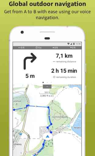
Record your own routes:
Start your track recorder and off your go! During your trip the app shows you where you are and what interesting destinations are nearby. The tracking feature enables you to record your own routes including data like duration, distance, altitude and interactive elevation profile.
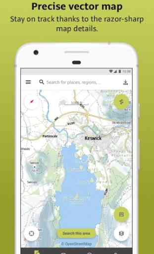
State-of-the-art map technology:
Enjoy a high-resolution display of all map details at all zoom levels thanks to a state-of-the-art vector map. Our digital summer and winter maps are based on official data sources, OSM. You can rotate all maps giving you the best possible outdoor orientation. The vector technology gives you the best Outdooractive route planner of all time.
Precise search functions & outdoor travel guide:
Use our search filters to get quick and reliable results. Find the best routes, offers, destinations, accommodation and events with our "Discover" function. Use it to also look for interesting destinations, events etc. near you!
Mountain hut directory:
Browse our large directory of places to eat & stay for information on opening hours, available beds, prices as well further info on many mountain huts. Created in cooperation with Deutscher Alpenverein (DAV), Österreichischer Alpenverein (ÖAV) and Alpenverein Südtirol (AVS).
Quick synchronisation:
Access your desktop-planned tours and lists with the app. Due to the smart synchronization between app and your computer your contents are always up-to-date.
Exclusive for Pro
Outdoor maps:
Additionally you will get the detailed topo maps with data from official sources for Germany, Austria and North Italy. You receive the exclusive Outdooractive map with more than 30 activities. You receive the appropriate maps containing the most important information and path networks for every activity such as hiking, biking, mountain biking & horseback riding.
Offline storage:
Download trails and digital maps directly to your smartphone and store them offline. Be perfectly equipped for your trip to the mountains, to a foreign country or a region with poor network coverage.
Create your own lists:
Routes, places or sights: Collect interesting discoveries in your very own lists or share them as tips for the community.
Exclusive for Pro+
With Swisstopo and IGN you also get the best maps for Switzerland and France with data from official sources as well as the official maps of the Alpine Clubs.
If you have any questions or suggestions, please contact us via [email protected].
Do you like our new Outdooractive App? We appreciate your review.
Category : Travel & Local
Reviews (17)
Appalling. Keeps crashing maps very laggy, difficult to consistently use. A shame because I was going to pay for a years subscription but a few days into my free trial I found it to be one of the worst apps I've ever experienced. Using it could get you lost, as it never seems to work consistently and shows errors saying the app has unexpectedly stopped, do you wish to continue.....
After a forced transfer from Viewranger I thought I'd give it a fair chance. The app uses far more memory than Viewranger even though the area covered by the downloaded maps is a tenth of what used to be on my phone. The route line of downloaded routes randomly disappears while on route. Sometimes it can be recovered often not. Rather than listing available routes in an area you zoom into the map & chose an icon. When routes start from the same place it can be impossible to separate the options
Just done the transfer from Viewranger, and only a few of my routes went. It's no where near as good as Viewranger, worst thing is the OS maps 1 25000 has a blur to it. Not great for planning routes. The Outdoor team need to really look into upgrading the package, or they will loose buyers! 15.05.22 - thanks to the response by Outdoor team. The app has improved and I'm starting to enjoy it more.
I was used to View ranger and to shift to outdoor was not easy. Now, after a while , i can say that the planner is better, and in general the app is good... Still i can't decide which is the best map to use. Which is the one comparable to the view ranger one ? Suggestion, create some ready to use the app video to initiate new users on basics: download map, switch maps, and routing
Disappointed, feels like a downgrade when compared to viewranger. I liked the features included with the apps aswell as the detail level of the free maps included... Guess I'll have to find a new outdoor app. Response to outdoor active response: if your app isn't finished you shouldn't end support for the previous feature rich app.
I had this free for a year. When that expired, I tried other apps but this is far and away my favourite for planning cycle routes, particularly off-road routes using the OS map and creating a gpx file to upload to my Garmin. I'm now paying for Pro for the next year. It's not 100% perfect when planning routes as it sometimes won't go down a particular bridleway but that's quite rare and just a minor irritation but that's why it's a 4 stars not 5.
Really disappointing. It uses OpenMaps so if you are in a remote area (where else would you hike?), you only see roads and waterways and maybe a bridleway if you're lucky. No landmarks, features, contours, public footpaths or anything else useful unless ... yeah, you guessed it - unless you pay. I loved Viewranger. I never got lost. Now I wouldn't rely on this. All you know is you're in a green marked area. How on earth do you find your way? Isn't that the purpose of a map? Typical problem of££.
I was really hoping after they took over viewranger it'd be a massive bonus. Sadly even though the interface is loads better the rest of the app is just garbage. No matter what route you take hours planning it chooses to take you on a completely different trail. I've always held off buying a garmin as view ranger was so good but now is the time. I do understand that you can turn automatic plotting off but every single time things are converted the app seems to know better even with existing gpx
I'm heartbroken, Just not as good as Viewranger was. Trialling pro membership to access features. Some main points so far: - No offline maps unless pro. Although there is a compromise offer by the authors allowing access OS map data by VR customers, but not offline! - BATCH POI import doesn't work tries to covert to a route! - BATCH POI management non existent. Can't select all/none in main list for deletion or batch addition to the clunky "list" method of showing data on map. :-(
Much improved. Latest update finally shows distances in miles and heights in feet on both the watch and phone. It's take a while but we're getting there. Can we have zoom controls on the map too? The ability to switch auto zoom off would also be a good option.
I'm updating my review after many hours trying to understand how OA works. It is too complicated, but some features work well, and others are annoying. I like the navigation, when it works. I keep getting an error message when I try to start navigation. It's also annoying when I lose the screen due to accidental touches or rain drops on the screen.
View ranger was far superior. doesn't seem to work as well offline, also its quite annoying when you zoom out to get a bigger picture it automatically changes to 1:50 and then up again to a sort of weird road map. it would be good to have some sort of locking feature to keep it on the scale you want. Or if that feature already exists then making it more obvious.
Have used ViewRanger for years. It was easy and intuitive. This is just absolutely useless. Trying to plot a simple route makes you want to throw your phone against the wall, which I did. Luckily it was in a tent. Sadly will be losing all the money I've spent, but deleting this now. You'll be better off with a pencil, a compass and an actual OS map. Or cut out the middleman and just start banging your head against the wall now without downloading this abomination.
Not as good as Viewranger. I've used the latter for years and I really like it, it's stable, easy to use and once you have the maps very reliable. Viewranger is now gone and after recent updates this app does work much better. Planning a route is still not as easy as before but no doubt that we'll also improve with time. It is getting better all the time.
Just discovered that has replaced Viewranger, which I've used, and enjoyed, for many years. Thankfully I was still able to have access to my OS mapping. However, my inital experience of this app is nowhere near as good as Viewranger. It's very annoying how the OS mapping automatically changes scale as you zoom out, meaning you can only ever see a very tiny area in 1:25000 before it jumps to 1:50000. The orientation moves as you zoom in and out too. Frustrating & disappointing!
Having been a viewranger user for many many years i was disappointed to be forced to 'upgrade' to this app, which is in my opinion far less superior to viewranger, and not nearly as intuitive. Trying to search for a postcode brings up many useless options, and everything takes longer to use. As a keen map user this is very frustrating, there is also no satellite mapping?? This feature i used in viewranger all the time as the 'map' is not necessarily the territory!! Disappointed.
Extremely disappointing. Features that were free in viewranger are now premium. This might be ok if the app was an improvement, but it's actually significantly worse. The only free map is terrible and not being able to see multiple routes on it makes day to day planning on hiking trips (comparing routes...) a pain. You don't get your altitude on the homepage map either. I noticed a lot of platitudes in the replies to other reviews. I just want IGN maps back on Viewranger, or I'll look elsewhere