

OwlsheadGPS Project
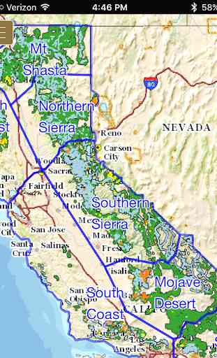
The OwlsheadGPS app includes more than 37,000 OHV and other motorized routes across lands managed by the Bureau of Land Management, US Forest Service, National Park Service, California Department of State Parks and Recreation, and other agencies throughout the State of California.
The OwlsheadGPS app allows you to:
√ Download trails and maps for any or all of seven regions to explore new and exciting areas outside the range of wifi and cell service,
√ Zoom and scroll across the map,
√ Display and update your location (iPhones and cellular iPads only),
√ View your location on the map whether moving or stationary,
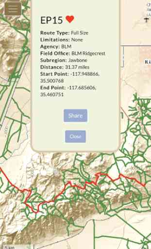
√ Record and view saved tracks with My Rides,
√ Like and share with Favorite Trails,
√ Manage the display of data layers for wilderness, national monuments, military lands, park lands and other special status areas.
Please note that in order to use the OwlsheadGPS app offline, you will need to download large amounts of data. The first region that you download will contain data that pertains to all regions. Additional data sets will be smaller and take less time to download. The downloading of trail and map data for offline use is most successful across very fast internet connections, and when your device is awake and the OwlsheadGPS app is open. You will see a confirmation alert message when a data set has been successfully downloaded and is ready to use offline. If you do not receive this confirmation alert, please try your download again.
Location Services must be on to display and update your location on the map, or to record your tracks.
Category : Travel & Local
Reviews (11)
Missing Stainslaus and Santa Clara County OHV areas (frank Raines ohv, Metcalf ohv) , so it's probably missing others as well. App won't close, just runs in the background until you force stop. Downloads have no pause or cancel, I had to reboot my phone to stop it, even after uninstalling.
Trail numbers are old,outdated, or nonexistent. Tracking isn't great either. 11/26/20.
wont download off-line maps. has been trying to for days but never finishes. used up over 5gb data trying though, careful.
Won't download maps, and hangs, uninstalled
Good app. But cant use offline
Couldn't get it past the initial start up
I'm very excited about this app. I've been looking for a list of ohv trails for a long time and this app is a great start to something wonderful! The issues in the negative reviews have been fixed. I would like to add information about the trails such as personal notes and difficulty levels. Please add a place in the app where I can donate to this project.
So angry with this app. Cost me $15 in data overage charges because it started downloading several GB of data without asking. I can uninstall but I can't get my data back. Most expensive free app ever.
Looks like a work in progress. Currently trails show up as a lot of lines with no ID. Moving location capability a must. Description says location only available on phones or phone tablets. Needs to be determined by device gps. Can only use as a map now with few identifying features.Needs to be able to be run from SD card. Looking forward to updates.
Downloads all the offline maps to internal memory, now I've run out of space on my phone, can't move it to the SD card, fail.
It calls itself a GPS app when it's really just a map app. Can't do anything but look at maps. Not even the offline download function works. How many years have you had to fix bugs, not to mention making the app actually useful?