Pacific NW National Forest
National Forests in the Pacific Northwest received over 15 million visits each year. This mobile app allows those visitors to easily discover recreational opportunities near them. Whether you're looking for information about a favorite hiking trail, searching for a new camping area, or looking for a great spot to see wildflowers or wildlife, turn your phone into an official recreation guide with the Pacific Northwest Forests app. Here are some ways of using this app to ensure you're taking advantage of all the great tools and information available:
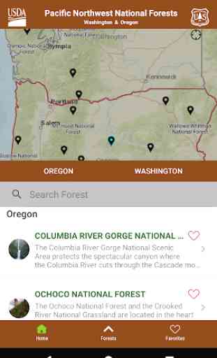
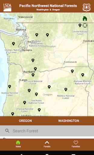
EXPLORE
Search for hiking, camping, picnicking, skiing, snowshoeing, cross country skiing, hunting, horse riding, climbing, mountain biking, road biking,scenic driving, and OHV/ATV areas using our interactive mapping tools or by looking through lists of all the recreation opportunities on each forest. Zoom in on maps and easily navigate to find information about any of our thousands of great recreation sites. Then get driving directions to the trail or campground.
BE PREPARED
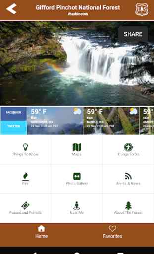
Find out about current road and trail conditions before you go, so you can be prepared to have a great experience in your U.S. Forest Service lands. All 17 forests highlighted in the app provide detailed information about road access and trail access. The app also provides updates on closure areas so you'll have the best information about recreation availability across the entire Pacific Northwest U.S. Forest Service system.
BE SAFE
Hiking and camping season are also fire season in the Pacific Northwest. Ensure the safety of yourself and your family by checking in with the app while making travel plans to visit your public lands. Current fire information is conveniently included in the app so you'll have the most up-to-date information about where fires are burning and what you need to know and do to be safe.
HAVE FUN!
Your Pacific Northwest Forests are some of the most beautiful places on Earth. They include breath-taking waterfalls, powerful rivers, deep and lush woods, spectacular vistas, expansive lakes, grand mountain peaks, and vast grasslands.
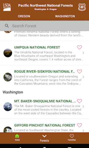
The 17 Forests highlighted in the Pacific Northwest Forests app include:
-Colville National Forest
-Columbia River Gorge National Scenic Area
-Deschutes National Forest
-Fremont-Winema National Forest
-Gifford Pinchot National Forest
-Malheur National Forest
-Mt. Baker-Snoqualmie National Forest
-Mt. Hood National Forest
-Ochoco National Forest and Crooked River National Grassland
-Okanogan-Wenatchee National Forest
-Olympic National Forest
-Rogue River-Siskiyou National Forest
-Siuslaw National Forest
-Umatilla National Forest
-Umpqua National Forest
-Wallowa-Whitman National Forest
-Willamette National Forest
ENJOY
Your U.S. Forest Service lands are here for you to enjoy. Check out our forest photo galleries included in this app to be inspired to explore new areas of the Pacific Northwest and discover the beauty and grandeur of the mountains, streams, skies and forests of your Pacific Northwest Forests!
Category : Travel & Local
Reviews (22)
This app is way to temperamental to bother with. From not loading to glitching and closing itself out randomly. And it doesn't matter if you have a perfect internet connection or not expect it to take upwards of 15 minutes to load anything. In theory this app could be amazing but at this point it's useless.
No filter by open campgrounds, so really only useful during summer. You have to zoom and click on each campground. Also, when the map redisplays after you've viewed the campground info, the zoom level is lost, so you have to zoom in again.
Terrible, I had the website bookmarked with the table for trailheads and roads open or closed, which now says you have to download the app. Download the app. and no table, maps will not load, app takes you to the website that tells you to download the app. Who are we paying to make this and test it with our tax dollars, rec fees, trailhead passes etc. They simply don't care and would rather have an app to look at our phones location to track us rather than a working website.
Poorly designed interface. Doesn't even give phone number to call campground or ranger service. Hard to navigate. Delete app and going to CampFinder app which is MUCH better!
Needs a lot of work. Maps won't load, roads and trails info for Glacier View Wilderness and Mt St Helens area are not listed in any app pages. If app doesn't improve soon I'll uninstall.
The app keeps spinning between landscape and portrait mode even though I'm holding my phone in portrait and don't have auto-rotae enabled.
The app is unusable due to a glitch causing it to rotate between portrait and landscape mode upon launch.
Almost useful, but too buggy - slow responses, closes randomly...
The app keeps closing when I try to open it.
Good info on road and campground closures.
google maps gives you more... why did they waste their time with this.... yasa, yet another stupid app
Very helpful for camping
Awesome reference. One stop shop!!
Pretty good but add idaho since the 3 NW states are Idaho, Oregon, Washington.
Unfortunately it closes itself before I can use it.
Now if we just had this app in more States
Don't waste your time on this application
I ran out of service
completely useless unless you just prefer looking at stuff on your phone rather than a PC. just like most apps out there these days, this is just a more complicated way of gettting info. cramming it all into one place doesnt always help!!! There is no real way to put together a plan for a hike or anything. all this is is the same info thats available online except crammed into a tiny hard to read map. the "recreation map" is nothing more than a MESS of un-labled trailheads which give you zero information. there is no actual route planner or anything. looks like the forest service just wanted to jump on the app bandwagon to appeal to all the kids out there who NEED everything to be in app form.
Just as little information as the online website. No info on trail closures or road closures. No trails on the maps, only trailheads. Alerts as old as 2010. If you get these things, then this would be useful.
Could be a good useful app, but its a bit buggy, needs work.
It needs to include interactive maps of trails, OHV & FS routes, waypoints & landmarks, campsites, hunting land boundaries, etc. (you know, things actually useful to someone exploring the parks). This app doesn't do anything not already available on a smartphone. And it directs user to the internet or a Ranger Station for maps. It's basically a digital advertising pamphlet for the PacNW parks.