
Paris Bus Map Free
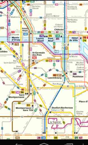
Paris Bus Map
- a simple free and offline map of all Paris busses, very useful for tourists and visitors.
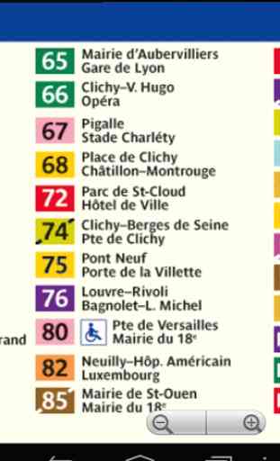
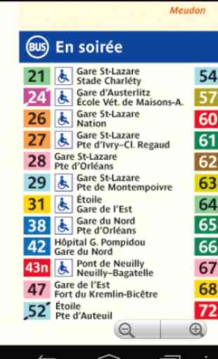
Bus services which are operated mainly in the city proper of Paris are named with two-digit numbers. Bus services which are operated mainly in the suburbs are named with three-digit numbers.
The RATP uses the numbers 20–96 for lines operated mainly in the city proper. The first number represents the terminal:
- 2 representing Gare Saint-Lazare
- 3 representing Gare de l'Est
- 4 representing Gare du Nord
- 5 represents Place de la République
- 7 represents Châtelet
- 8 represents Quartier Latin
- 9 represents Gare Montparnasse
The second number represents the outermost arrondissement:
- 2 represents the 16th arrondissement
- 3 and 4 represent the 17th arrondissement
- 5 represents the 18th arrondissement and the 19th arrondissement
- 6 represents the 20th arrondissement and the 12th arrondissement
- 7 represents the 13th arrondissement
- 8 represents the 14th arrondissement
- 9 represents the 15th arrondissement
The RATP operates 59 bus lines within the city of Paris proper, and 205 bus lines in Paris suburbs. In 2004, 953.6 million journeys were made on RATP bus lines, including 352.2 million journeys on Paris lines and 601.4 million journeys on suburbs lines.
- a simple free and offline map of all Paris busses, very useful for tourists and visitors.
Bus services which are operated mainly in the city proper of Paris are named with two-digit numbers. Bus services which are operated mainly in the suburbs are named with three-digit numbers.
The RATP uses the numbers 20–96 for lines operated mainly in the city proper. The first number represents the terminal:
- 2 representing Gare Saint-Lazare
- 3 representing Gare de l'Est
- 4 representing Gare du Nord
- 5 represents Place de la République
- 7 represents Châtelet
- 8 represents Quartier Latin
- 9 represents Gare Montparnasse
The second number represents the outermost arrondissement:
- 2 represents the 16th arrondissement
- 3 and 4 represent the 17th arrondissement
- 5 represents the 18th arrondissement and the 19th arrondissement
- 6 represents the 20th arrondissement and the 12th arrondissement
- 7 represents the 13th arrondissement
- 8 represents the 14th arrondissement
- 9 represents the 15th arrondissement
The RATP operates 59 bus lines within the city of Paris proper, and 205 bus lines in Paris suburbs. In 2004, 953.6 million journeys were made on RATP bus lines, including 352.2 million journeys on Paris lines and 601.4 million journeys on suburbs lines.
Category : Travel & Local
Related searches
Reviews (4)
Kei. K.
Jul 3, 2014
This app brings you frequent pop up ads
Moh. E.
Feb 1, 2017
Nothing
A. G. u.
Nov 11, 2012
Constant pop up ads from downloading this app. Went away after uninstalling.
No dofferent than loading the pdf bus map on tablet. Be nice if you could tap bus number and separate image with stop names comes up and work with my gps on tab 3.