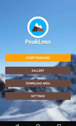
PeakLens
Discover the names and locations of mountain and hills around you while hiking, climbing, skiing, trekking or enjoying your favorite outdoor activity. Test your mountain knowledge and share your pictures of stunning skyline views with your friends on social networks.
FEATURES
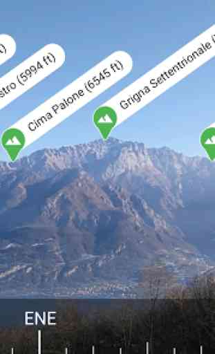
- Precisely identifies mountain peaks and hills in real-time.
- Works worldwide: from Alps, Himalayas, Rocky Mountains and Andes up to the smallest hills, anywhere on Earth.
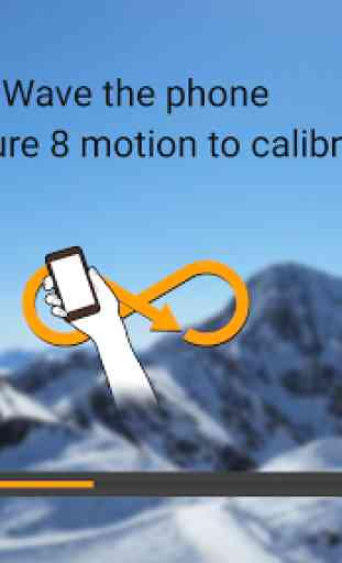
- Corrects GPS, compass, magnetometer and gyroscope errors with artificial intelligence.
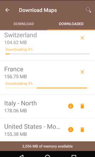
- Works online and offline with pre-downloaded maps.
- High quality photographs with peak names in overlay.
- Knows position, height and distance from you of more than 200.000 peaks.
- Works both with Imperial and Metric unit systems.
PeakLens is a novel Augmented Reality and Virtual Reality app for mountain lovers, hikers and trekkers. It is the result of years of research in artificial intelligence and computer vision, based on a novel algorithm that identifies mountain peaks in real time with high precision. Its core is a software component that compares what you actually see in the camera of your mobile phone or tablet with a virtual panorama, created from a digital 3D landscape model of the Earth. By matching what you see and the virtual panorama, PeakLens automatically corrects most errors that come from the imprecision of the compass and GPS sensor, giving you always the most accurate peak positioning.
RESOURCES
- Digital Elevation Model: the digital elevation model of the SRTM project (https://www2.jpl.nasa.gov/srtm) is used for calculating panoramic views.
- Peaks: the Peaks dataset is extracted from Openstreetmap.com.
OpenStreetMap is open data, licensed under the Open Data Commons Open Database License (ODbL).
PeakLens is a research result of Politecnico di Milano, Dipartimento di Elettronica, Informatica e Bioingegneria.
For any comments, questions or feedbacks contact us at [email protected]!
Category : Travel & Local
Reviews (22)
Great idea, but the app is far from perfect: * For offline mode, it requires too much permissions. I do not want to give it permission to access my photos and other files. The app could have stored the data in /sdcard/Android/data, which is possible even without storage permission. * The AI finds peaks even in a room. That would be OK (and expected) for compass-based detection, but it “finds” and moves all the peaks after a while. This does not look very reliable.
Good concept, good enough for approximately identifying peaks, but inaccurate. VERY much needs a method to provide a manual adjustment once calibrated. It's always off by a significant amount. So somewhat useless in the end. Also needs an extra small text/label option. Labels take up too much room.
Useless. You virtually have to be standing on the peak/mountain you want to identify for this to be accurate. Uninstalled.
Cool idea but unfortunately it's not accurate. Tried it just now and it did list some mountains in my area and lined it up nicely with the peaks on the camera, unfortunately they were completely wrong and in different area of my city. Too bad.
Great app. As long as your phone has capable accurate compass & GPS PeakLens works very well. There are gaps in the OSM data it uses for peak id. In south east Australia the peaks can be patchy but I have used this in France, Austria, Slovenia, Montenegro with success. The peaks label display moves if the phones internal compass moves. The peak id in AR view can be distorted by clouds and trees. Suggestions - options to display peak distance (saved on the json) & adjust label transparency.
I live in the Canadian Rockies. With the downloaded map for this area Peaklens works great off-line out in the feild and even out the car window while travelling through the mountains (as a passenger). As with any of these types of apps it is important to calibrate the GPS to get accurrate results.
Does not find the highest peak in my area (4000m) despite trying from many different angles.
I could never get an accurate reading using this app on my Pixel. I pointed it directly at a 14er I have climbed and got either the wrong peak name, or no peak at all. Good concept. Needs some serious work.
I was on EBC trek. I downloaded the offline data for Nepal. It was working before at AC. Unsuspectedly, when reaching some hills, it said i do not have the offline data for this region. While i had it. Reaching back to network area i deleted and downloaded again, now it is working. But too late. I missed Mt Everest.
Surprisingly good and accurate. It took me several attempts to calibrate though as the instructions were a bit unclear.
I originally downloaded this app about a month ago. At that time, it just crashed my phone whenever I tried to use it. Now, I am happy to report that it works perfectly, and is a very useful tool.
I *guess* is shows elevation in relative feet, not ASL. Thats as useful as, well nothing. Does a terrible job identifying peaks anyway. NONE of the peaks identified are in my state...
Doesn't work. Downloaded area but kept telling me no peaks while I was staring at peaks. Worked one time but never again. Other app showed I had GPS.
Great app idea, however, doesn't work well at least not on my phone. But is is free of charge without adds, so thumbs up 👍.
Loved this ap untill the latest update. now all it does is chrash. will not work pn other phones my family has either. Aug 9. still will not work. Will not load on or off line.
Unfortunately this has not worked multiple times. It worked for about 3 minutes once and nothing works since. All mountains are apparently mount maroon.
God awful. It can't even find a mountain when I'm looking right at it
I loaded this to identify mountains on the horizon 20 - 30 miles away. It only names little hills nearby, so it isn't what I wanted.
No matter how many times i calibrate the compass the mountain peaks always are way off to the right of where they should be
Says I'm traveling south when I'm going west. Names mountains as long as I'm not looking at them. Can I just pull the compass myself? It would be much more usable.
Neverending notification bar searching for something and consuming battery. Uninstalled.
It works but it seems to off by a quarter mile everywhere. It's not exactly 100% . I know the mountains in my area. It needs an upgrade. Cool app. Needs tweaking.