Pegelstände Niedersachsen
Shown are only the high water mark of Lower Saxony, the responsibility lies with the NLWKN and a variety of levels of the Federal Waterways Administration, located in Lower Saxony (see also http://www.pegelonline.nlwkn.niedersachsen.de): Note. Level data from other federal states are not displayed.
Have you ever been affected by floods or even flooding?
With the official app of the water levels NLWKN (Lower Saxon State Department for Waterway, Coastal and Nature Conservation) You can now go and inform the home of the current level of Lower Saxony waters.
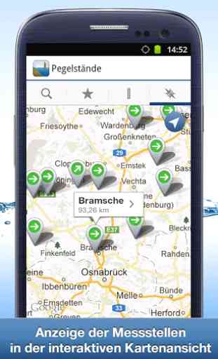
Find tag along rivers in your area using the built environment and search of innovative map browser, add them to favorites and keep as a constant overview.
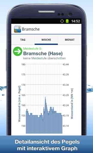
The trend calculation and display of the current reporting levels help you in time to induce action if your belongings was endangered by rising waters.
The affectionate design and ease of use make this app the number 1 reference in water levels Apps.
features:
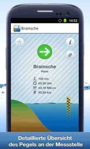
● current water levels of Lower Saxony Rivers
● Push notifications
● trend calculations (the level as increased or decreased?)
● Favorite List
● Proximity search
● overview map with integrated trend and alarm level display
● detailed daily, weekly, monthly overview of the level curve in a clear graphic
Have you got questions NLWKN Pegelapp?
Contact us at: [email protected]
Please note:
When opening the application (also from the background) an Internet connection is required to ensure that the current data can be loaded.
The timeliness of the data is from the dataset of the NLWKN dependent, there can therefore be no guarantee that the data is complete and correct.
Have you ever been affected by floods or even flooding?
With the official app of the water levels NLWKN (Lower Saxon State Department for Waterway, Coastal and Nature Conservation) You can now go and inform the home of the current level of Lower Saxony waters.
Find tag along rivers in your area using the built environment and search of innovative map browser, add them to favorites and keep as a constant overview.
The trend calculation and display of the current reporting levels help you in time to induce action if your belongings was endangered by rising waters.
The affectionate design and ease of use make this app the number 1 reference in water levels Apps.
features:
● current water levels of Lower Saxony Rivers
● Push notifications
● trend calculations (the level as increased or decreased?)
● Favorite List
● Proximity search
● overview map with integrated trend and alarm level display
● detailed daily, weekly, monthly overview of the level curve in a clear graphic
Have you got questions NLWKN Pegelapp?
Contact us at: [email protected]
Please note:
When opening the application (also from the background) an Internet connection is required to ensure that the current data can be loaded.
The timeliness of the data is from the dataset of the NLWKN dependent, there can therefore be no guarantee that the data is complete and correct.
Category : Tools
Related searches