PocketFMS EasyVFR for Pilots
* This app requires EasyVFR aeronautical & WX data to function.The required data is provided for free with an existing PocketFMS license, or by a yearly subscription obtained as an in-app purchase when this app is first run: -Europe 69.95 Euro -Australia/NZ A$59.95 -Canada CAD59.95 -USA US$49.95The subscription provides current AeroData for Europe, USA, Canada & Australia/NZ, published in line with the 28 day AIRAC cycle. It includes current NOTAM & WX for all supported regions and enhanced European WX forecasts from our contracted professionals.
EasyVFR is an aviation Moving Map/EFB which can be used for flight planning, easy GPS navigation and post-flight analysis on Android devices (min. Android 3.x, 1GB RAM / 2GB storage). It is fully integrated with the PocketFMS Flight Management System.
With EasyVFR you can plan your flight, take your phone or tablet with you in the cockpit and follow your route on a moving map, always confident of your position and the airspace and airports around you.
PocketFMS has been providing flight planning and moving map systems since 2003. PocketFMS is a complete Flight Management System for VFR pilots, designed by pilots for pilots, that makes flight planning and navigation easy. Our AeroData is professionally maintained to the highest standards, including AIP updates for Australia/NZ, Canada, Europe & the USA, and is used in leading panel mounted avionics.
Currently the following is implemented:
- Unique 3D View (Synthetic Vision) for Europe, Australia/NZ, Canada (up to 60N) and USA;
- Terrain shading relative to aircraft altitude in both 2D and 3D view;
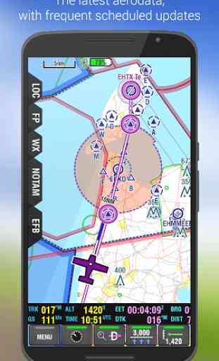
- Full PocketFMS AeroData support including many non-AIP airports, VFR reporting points, obstacles, navaids, places;
- Efficient flight planning. We have designed the easiest and fastest way to create multi-leg flightplans, starting with a tap & hold on a location on the map;
- Printing of flightplan briefings (NavLog,Weather,NOTAMS & Airspaces) using our unique EasyPrint system;
- Digital ATC flight plan filing for Europe and USA. NAIPS NfW file export;
- Quick and easy Direct To;
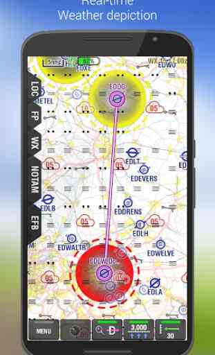
- Integrated Weather: PocketFMS' renowned Weather Information System provides graphical METAR/TAF depiction, W/V at different altitudes, and European Advanced WX forecast (cloudbase, SigWX
- rain, fog, thunder);
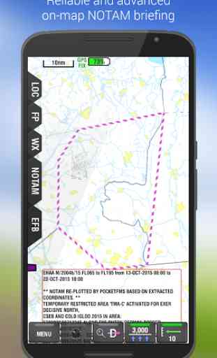
- Graphical NOTAM depiction;
- Beautifully clear & detailed PocketFMS base mapping, or official charts for selected countries;
- Practice as if you are flying, while safely on the ground, by connecting your device to the free PocketFMS Simulator: http://www.pocketfms.com/phpBB3/viewtopic.php?f=38&t=7829
- EFB Documents System with :
* Europe : All European Approach Plates from AIP's, Pooleys and DFS Anflugkarten, many geo-referenced
* Australia : ERSA & DAP Charts
* New Zealand : not supported
* USA : FAA's A/FD Directory.
* Canada : COPA's "Places to Fly";
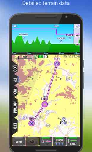
- Vertical Profile View for airspaces, terrain and obstacles, for both Planning and actual Flying.
- GPX flightplan import & export.
EasyVFR Tutorials: http://www.pocketfms.com/EasyVFR/tut-FirstRun.asp
Learn more about PocketFMS at our web site and the PocketFMS Forum: http://www.pocketfms.com http://www.pocketfms.com/phpBB3/index.php
•We have a 30-day money back guarantee
- if you're not satisfied, please contact us;•Your payment will be charged to your Google Play account at confirmation of purchase;•Your subscription is automatically renewed unless auto-renew is turned off at least 24 hours before the end of the current period;•Your account will be charged for renewal within 24 hours prior to the end of the current period;•Subscriptions may be managed by you and auto-renewal may be turned off via your Subscription Settings in Google Play after purchase.
Category : Maps & Navigation
Reviews (29)
Great app very impressed and very reasonable cost per year I think I paid about 90 euros and pilot aware hooks up to it so no need for another tablet great job.
Used it for 10 years all over Europe (and Morocco). Totally adequate.
I have been PFMS products for many years...nothing short of excellent!
Old maps for Sweden, railway and major power lines etc
Locks up when I download METARS or NOTAMS. Version 3.97 Edit, won't work on my phone nor my tablets, finally had to delete the APP because I couldn't get any support. Wasted 60 bucks on this.
Never fly without it.
I don't think I'm going to invest in this. Had high hopes but both the phone and p.c versions don't even manage to open. How am I supposed to trust it on the air??
There are some nice features compared to other similar products, but the user interface is quirky in the extreme and matches no accepted Android (or IOS) paradigms making it very hard to use. Most control is through pages of identical buttons arranged in a grid with little or no logical structure. In many cases using buttons so small that the text-only labelling has to scroll. The lack of icons makes this feel like an app written in the dark ages.
This app is just brilliant. I find that I can now plan a flight in a fraction of the time with complete confidence. Ive crossed checked all calculation by hand and NOTAMS with official NATS publications and all is perfect. Can't recommend jointly enough. Thanks guys for a wonderful app!
Had such high hopes. NOTAMS not right, even after force download, EFB not working (shows download pending, can't dowload). Will be contacting support. I don't feel confident with using any of the data at this point.
I've been a long time user. It just keeps getting better and better!
You wanna fly from point A to B? Fine. But if you want to fly from point A to B to C to A you will literally get insane by the very bad usability in this tool.
Works great on my Samsung! Easyvfr is the best
The best flight planning and moving map system around!
Just keeps getting better with each version!
Excellent app, does everything required and more. First class support and continuous updates and improvements, many from user suggestions. Also fully integrated with the up and coming PilotAware Traffic Awareness system being developed by Lee Moor.
An excellent aid for the VFR pilot although I would prefer a little more map detail, such as motorway and major waterway labelling. I always fly with a 250,000 toppo and can always refer to that, but it would be nice to have at the higher zoom levels. Where is Meppershall, by the way? Having such a wealth of information available at a touch is really great but takes practice to become fluent...but then, what doesn't?
Been using PFMS for years. App is so full of features and kept well up to date
Just keeps evolving and getting better. The programmers are always available to help on their website.
If there was one additional feature that would put the cream on it is the inclusion of spot heights on the map (or am I missing something?)
One of the most comprehensive navigation packages on the market. The NOTAM service is a great addition.
Each iteration is an improvement, appreciated.
rely on real Nav instrumentation of course... But cool all the same....
Installed OK, but fails to run, crashing back to the home page. As I want something reliable in the cockpit, I'm extremely unlikely to ever bother installing ths.
Only complaint is that I would like to see the app use phone hardware buttons, like back or menu.
... Unlike "the other aviation software". Some non-androidisms in UI but works well. Regular nav database updates are great!
And very complete. I won't fly without.
Have used pocketfms on my ipaq for several years but the android version is a huge leap forward.
Helpful also for gliders I use beta v4. Like it. Safes me from carrying multiple maps or re-fold them in a small glider cockpit when flying across boundaries. All essential info quickly available including zoomable terrain maps. Good readability also on smartphone.