
Postholer Trails GPS
Using your devices' GPS the Postholer Trails GPS app will place you along your favorite trail using manual or tracking location features. Complete track and way point data for the Appalachian Trail (AT), Pacific Crest Trail (PCT), Continental Divide Trail (CDT), John Muir Trail (JMT), Colorado Trail (CT) and Long Trail (LT) is available from within the app at no extra cost.
Features
Locate yourself with your GPS manually or periodically with tracking mode, walk the trail anywhere in 'Sim Mode', create way points, filter way points, set way point alarms, off trail alarm, standard or SI units of measure, 12-24 hour clock, reverse trail direction, NAD83 decimal degree coordinates, get weather reports at specific trail locations, update your Postholer Journal. Full topographic maps. Telemetry footer (trail mile, elevation, proximity, speed, latitude, longitude) on every page. No advertisements or in app purchasing. Wildly configurable to meet every hiking style.
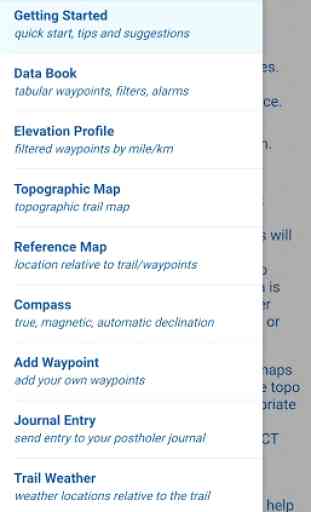
Getting Started
The home page will help you get started quickly and provides all the information needed to use the app effectively. Be sure to read the tips and suggestions for configuring the app to other than default settings. You'll also find support contact information here.
Data Book
The data book is a tabular list of way points, mile, elevation, distance to next, distance to previous. Your device GPS keeps you at the nearest way point. You can filter way points and set way point alarms from this page.
Elevation Profile
View the trail in terms of elevation by trail mile. All your filtered way points are displayed here. Each way point type has it's own distinct color. You can easily pan to any part of the trail.
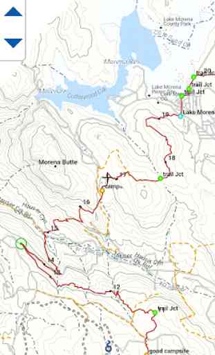
Topographic Maps
Complete set of topographic maps for each trail. These are unique, Postholer created maps and not the old topo maps found in every other app. Uniformity in style, colors and unit of measure. You'll really appreciate the land cover in these beautiful maps.
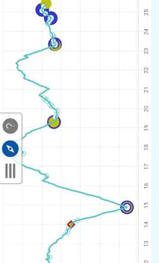
Reference Map
Here you can see where you are in relation to the trail and your filtered way points. Your way points are shown as mile markers. Again, you can easily pan to any part of the trail.
Compass
Using the magnetometer in your device, the app displays your heading in magnetic north as well as true north. Declination is automatically updated by using the device GPS and World Magnetic Model (WMM) data. To switch between magnetic north and true north flip the toggle on the 'Preferences' page.
Add Way Point
You can add a way point at your current location or specify a different coordinate. A short description, location type and detailed description are the pieces of a each way point.
Journal Entry
Update your Postholer Journal with all the info available in your journal. Add a photo, text and coordinate, the resulting email can be sent off via your native email app to your journal at the Postholer site.
Trail Weather
No hiking trip should be without a current weather report. Get point forecasts for trail specific locations by trail section, section high point and section low point.
Preferences
Here you can download trail track/way point data and configure the app to your hiking style. You'll find many different settings...be careful!
Features
Locate yourself with your GPS manually or periodically with tracking mode, walk the trail anywhere in 'Sim Mode', create way points, filter way points, set way point alarms, off trail alarm, standard or SI units of measure, 12-24 hour clock, reverse trail direction, NAD83 decimal degree coordinates, get weather reports at specific trail locations, update your Postholer Journal. Full topographic maps. Telemetry footer (trail mile, elevation, proximity, speed, latitude, longitude) on every page. No advertisements or in app purchasing. Wildly configurable to meet every hiking style.
Getting Started
The home page will help you get started quickly and provides all the information needed to use the app effectively. Be sure to read the tips and suggestions for configuring the app to other than default settings. You'll also find support contact information here.
Data Book
The data book is a tabular list of way points, mile, elevation, distance to next, distance to previous. Your device GPS keeps you at the nearest way point. You can filter way points and set way point alarms from this page.
Elevation Profile
View the trail in terms of elevation by trail mile. All your filtered way points are displayed here. Each way point type has it's own distinct color. You can easily pan to any part of the trail.
Topographic Maps
Complete set of topographic maps for each trail. These are unique, Postholer created maps and not the old topo maps found in every other app. Uniformity in style, colors and unit of measure. You'll really appreciate the land cover in these beautiful maps.
Reference Map
Here you can see where you are in relation to the trail and your filtered way points. Your way points are shown as mile markers. Again, you can easily pan to any part of the trail.
Compass
Using the magnetometer in your device, the app displays your heading in magnetic north as well as true north. Declination is automatically updated by using the device GPS and World Magnetic Model (WMM) data. To switch between magnetic north and true north flip the toggle on the 'Preferences' page.
Add Way Point
You can add a way point at your current location or specify a different coordinate. A short description, location type and detailed description are the pieces of a each way point.
Journal Entry
Update your Postholer Journal with all the info available in your journal. Add a photo, text and coordinate, the resulting email can be sent off via your native email app to your journal at the Postholer site.
Trail Weather
No hiking trip should be without a current weather report. Get point forecasts for trail specific locations by trail section, section high point and section low point.
Preferences
Here you can download trail track/way point data and configure the app to your hiking style. You'll find many different settings...be careful!
Category : Travel & Local
Related searches
Reviews (2)
Wal. A.
Feb 13, 2021
App will not load map of CT.
This app will not recognize any of my email programs on my Pixel phone, even the default app