PPGpS Lite
Welcome to PPGpS, a Flight Computer for Paramotor, Paraglider, Glider and Ultra Light plane Pilots
*WARNING there are missing features in the Lite version:-Log flights in KML/IGC format-Waypoints management-Airspace display-QNH/QFE altimeter setting-Android Wear smartwatches via PPGpS Wear compatibility-The annoying popups are removed in the Full version-Display instruments on your Android Wear SmartWatch
*FEATURES OVERVIEW:-Real time flight information -Wind direction and speed estimation-Takeoff and Landing phases auto-detection-Return home information (display estimated travel time and bearing)-Fuel calculation and warning-Airspace display (OpenAir files)-Emergency geo-localized SMS-Localization with GPS-Barometric sensor support to improve altitude accuracy-QHN, QFE Altimeter setting-Online and offline maps-Offline maps creator-Google Maps and OpenStreetMap map providers-Rotating Map-Log flights in KML (for Google Earth), IGC (Leonardo servers) and GPX files-Replay recorded flights-Waypoint management -Especially developed for Paramotor-Embedded User Manual and Tip of the day feature.-Real time flight tracking on www.ppgps.info-Variometer-Sunset time-FlyNet2 variometer support-Flight Bandit variometer support-Android Wear SmartWatch support with PPGpS Wear
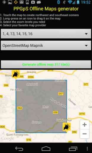
*MAPS:Online:PPGpS can display Google or OpenStreetMap maps in connected mode.Offline:Download map files in your smartphone in case you don't have an internet connection during the flight.Use the integrated PPGpS Offline Map Creator to generate offline maps.
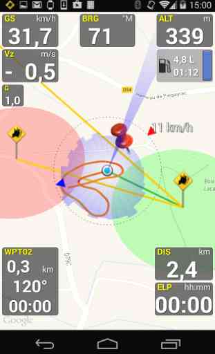
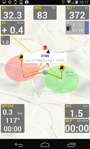
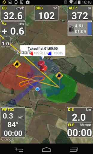
*INSTRUMENTS:PPGpS provides the altitude, vario, bearing, magnetic compass, acceleration and ground speed.With just one click on instruments you switch easily between different data modes : instantaneous, average and maximum values.Altimeter can be set to actual altitude or elevation (QHN, QFE) just by long-pressing on the altimeter.If your smartphone has a barometric sensor, it could be used to compute a very accurate altitude.You can use PPGpS Wear companion application to display your instruments on your SmartWatch.
*WAYPOINTS:Create waypoints by tapping on the map or by entering their GPS coordinates.Select a waypoint with one click on the waypoint instrument (WPT).Rename or remove a waypoint from the contextual menu of the waypoint list.Follow the displayed route (bearing, estimated travel time and distance).Prepare your waypoints from Google Earth and import your KML files (PPGpS folder in the phone).Waypoints may be automatically loaded at startup and saved at the end of the session.In case your KML file doesn't import well, please send me the file and I will fix it quickly.
*WIND AND SPEEDS HUD:The average ground speeds are graphically displayed for every azimuth.The wind direction is displayed (red arrow) and may be reset at any time during the flight.
*RETURN HOME:Home direction and Estimated Travel Time to return home is always displayed (shaded red line).Computations are done according to the wind for accurate results.
*LIVE TRACKING:Enable the Live Tracking feature to allow your friends and family to see you live on map ! Go to www.ppgps.info for more details.
*AIRSPACE:Copy OpenAir files in the /ppgps/airspace folder to display airspaces on top of the mapUse my other app AirspaceMap to help you download and customize your openAir fileshttps://play.google.com/store/apps/details?id=com.ns31.airspacemap
Launch the Demonstration mode to have a quick tour.
Visit http://www.ppgps.infoFind us on Facebook : https://www.facebook.com/ppgpsand Twitter : https://twitter.com/PPGpSAndroid
Enjoy your flights with PPGpS and thank you for your feedback.Don't hesitate to send me your kml flight logs by mail : [email protected]
Category : Sports
Reviews (15)
Purchased full version but refunded immediately. Downloaded airspace but it does not show the heights of airspace, so useless than. I fly under class b and NEED to know what my limits are without having to open another app. Goodbye.
Purchased full version. Great app if it didn't kept crashing multiple times throughout the flight. Might have to get an iphone just so I can switch to flyskyhy
Can't get out of the start up tips. App is completely useless.
Can't get past tips to allow GPS access, hopeless to review.
For what is supposed to be an evaluation version, your cant even evaluate it. Too many things disabled. Suggestion for the creator, give full permission for 30 minutes, then restrict the features.
This app drops features from the paid app. Enough to not know if the paid app works properly or if those features are useful. Missing items are altitude correction, waypoints, airspace, etc. Also the menu UI is buggy. I'm not able to use the phones menu button to get to the menu. It pops up and immediately dissappears.
Too many pop-ups to test the app.
Many thanks for the excellent work. Raidan
Give more attention to the inbuild magnetic compass. Relaying on the GPS derived compass only, is a mistake!
Could be very usefull
Love it
This app looks really good but does not work on the Nexus 7. I have emailed the developer but is unable to find a fix for this. Other than that it does look really good
Wind speed and AGL altitude needed.. But for now the best PPG application in the Play Market.
Its for flying ppg its awesome
Every 2 mins or so you have to press back button to remove pester box to upgrade to full version. Not a whole lot of time to look for other features and try them. Free version not really useful as youll probably fumble the phone in mid air.