

QField for QGIS - EXPERIMENTAL
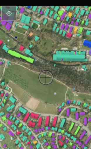
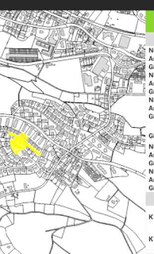
QField unleashes the full power of the QGIS styling engine to bring your customized maps to the field, collect attributes for features with configured edit widgets like value lists, checkboxes, free text or pictures taken with the device camera.
QField is an open source project, the documentation, much more information, the source code and possibilities to to support the project can be found at qfield.org (preferred) or by buying the QField for QGIS Karma edition app (http://qfield.opengis.ch/karma).
QField is built from ground up to be touch oriented and easy to use outside.
It is based on a few paradigms● GPS centric● QGIS desktop compatible● Fully working when offline● Synchronization capabilities● Project preparation on desktop● Few and large buttons● Mode based work (Display, Digitizing, Measuring, Inspection,...)
QField is built using Qt5, QtQuick 2 (both are supported and suggested by Qt) and OpenGL so it is future proof and it spearheads QGIS towards Qt5.
OPENGIS.ch is happy to help you with the implementation of missing features. Contact us at http://www.opengis.ch/contact/For bug reports please file an issue at https://github.com/opengisch/QField/issues
Category : Tools
Reviews (22)
Not happy that lost the ability to open a project in *any* folder. UPDATE: another star for the quick response from the developer
Hi guys, you're doing such a great job. I can't open Zipped projects which are password protected. Would you please come up with a solution for the issue? It's important for securing our data I guess. Thank you for your endeavors on Qfield development.
Esri who? QGIS and QField work great for 99% of GIS applications. I use it for mineral exploration. Open source developers who make it happen are heroes. Thank you!
Good free android app. Displays and collects GIS data like no app I have ever used
As an archaeologist I use QField nearly everytime I am doing fieldwork. Although, it doesn't replace total stations or RTKs it is a great simple mapping solution for many of the tasks that don't require that high of precision. I use it for photo logs, coordinating surveys, displaying historic maps, artifact point plotting, mapping test pits etc ...
This app is amazing, takes a second to fiddle around and figure out the controls, but it's extremely simple and easy to use once you figure it out 100%. I use this app 5 days a week for a local government job, and I really appreciate the simplicity of use. I like that it allows for local saving on the device (most others use exclusively cloud, which is data heavy, and not necessarily as reliable as hardware based data. After trying others, will continue with QField. Thank you, devs.
Mapping on the go. A great application. I used it my final year project. From getting started with the project in QGIS desktop, configuring various settings, installing the application in an android device to using the application in data collection both offline and online was simple. The UI is great , no ads (that's a plus), camera is working quite well. The application rarely crushes: very stable. GPS accuracy is great. Lastly, using QField Sync plugin with the app was great experience
Have only had limited opportunity to use it for viewing project files so far, nothing more advanced. Although the project files do include WFS and WMS layers. Have upgraded review from 3* to 4* given recent improvements. Constructive feedback so far: # Fields with long text strings are still impossible to read in attribute viewer. # "Recent Projects" UI items don't respond to interaction vs take time to load so it's hard to tell if touches have been registered by the app.
Awesome app for geologist collecting data in the field. So nice to find something that works! Only suggestion for user interface would be to modify the ability to scroll left or right once a description is too long.... On the phone you must backspace first to see the small bubble. Also a clinometer built in would be nice! Also a camera to geo reference photos right in the project would be awesome!
Essential if you want to use QGIS in the field. Works very well for me once I learned to check that everything was using the same coordinate reference system, which really has to be 3857 if I'm trying to add photos. Also seems to work better on pixel 5 than on galaxy s7 edge, which for some reason didn't like Google satellite or similar tiled services as a background.
One moment I was able to save 3 POIs. The next I could not bring the + icon in the screen to add more. Still need more space to improve on. I rerun the whole thing to create a new layer and the map put me in the middle of an ocean. Checked google maps, my fone gps is still okay, it put me where I should be. Sadly most apps like this are being released to make us users beta testers. I know, this is an open source based app, but there is always a better alternative like Viewranger.
This app has made all my geological mapping, drill hole locating and general field duties as a geologist just seamless and integrated. This app brings the QGIS program directly to your phone in such a smooth way. Having followed this app now for over 2 years I can say the stability and functionality had improved out of site and would just like to say thank you to the hard working and dedicated team behind this development. I look forward to many more years of progress.
I can see the potential! I need to add photos to my features, but when I take a photo, the preview photo is blurry and then the app crashes! I really need this to work, so if someone could get back to me about this I would really appreciate it and bump my stars up to 5!
Very useful app for field data collection. I am very expectant for the cloud sync to be enabled to be able to update remotely and share the project to more users as data collectors and avoid the USB method of synchronisation.
No longer able to use in conjunction with Samsung Game Launcher. In previous versions i could decrease the graphics quality to 30% on my Samsung tablet. This helped speed up QField especially when using a large raster base. Samsung Games Launcher now says "Qfield is not a Game and some optimisation features are not allowed" it would be great if this functionality could be brought back natively in QField.
Awful app, doesn't work as smooth as it looks on videos. Tried to download projects and just kept saying they couldn't find them. Tried searching for the problem online to no avail. Their documentation leaves a lot to be desired too, not enough info on what you need on your phone or how the project should be set up. Stuff like this really needs step by step instructions and the reasoning behind those steps so no one takes it for granted.
works great for simple projects. loaded geopackage imagery, and it seems to load flawlessly, but gdts a bit bogged down by larger files (100 mb+). having some issues with the editing function (my edits won't save), but otherwise i am quite happy with the program.
Cool concept but not useful. I tried it on android 6, and there were no options to plot points/features. So not useful. From what I've read, there is supposed to be a yellow circle with a pencil in the lower right corner once you enable digitization.
great but need to be able to access cloud storage as files are easier to get then. i had to plug my phone into the laptop and move the file to my download folder as i could not get to it otherwise. not with google drive nor with my downloads folder.
Very nice application. I have used it every day during 3 weeks to digitize parcels and fill-in the related attribute table (including photos) without any problem. It is a great advance for the GIS field work. Thanks a lot !
The latest version which is updated 8 hours ago is crashing on its opening. On the latest I did a fresh install and it's working. In the meantime I used development version. Software is very good and easy to use thanks for great job
I'm starting to get to grips with it. Seems very good do far, 2 weeks in. Using the cloud is a vast improvement .