ROAM GPS:Recreation Maps&Tools
ROAM turns your phone or tablet into a handheld GPS with extensive outdoor map data! Find new places to recreate using the most complete public lands & open spaces maps ever created. Going out of cellular data coverage? No problem! Your GPS works even without cell service and you can save your maps and markups for offline use.
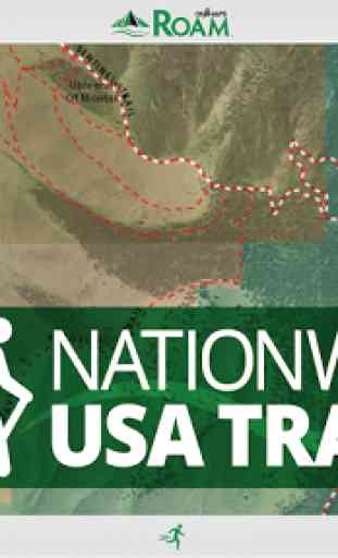
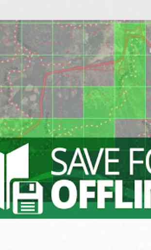
•Turn Your smartphone or tablet into a powerful handheld GPS•Discover new trails by browsing the most comprehensive nationwide trails map ever created•Find Open Space with onXmaps’ accurate Public Lands data•We’ve combined all your paper maps into a much more customizable digital map suite•Turn Map Layers and Basemaps on and off to customize your maps for your favorite activity•See Recreation Access Areas and Water Sports Access Points•Switch between comprehensive Base maps including Aerial imagery, 24K topo, and Hybrids•Save Maps for Offline Use when out of cell coverage•Create Geotagged Photo Waypoints and Customized Waypoints•Auto-Sync and Share Waypoints, Tracks, Measurements, and Stats with your Team and between your devices
FREE TRIALWhile the App and many of it’s features are free. You will start a free Roam Nationwide and State Private Parcels trial when you install the App. This allows you to try our full app for 7 days.
ROAM APP FEATURES
▶ MAP DATA FEATURESFrom mountain biking to kayaking, from the summit to the sea, if you love outdoor adventure
- WE GUARANTEE there is time-saving map data in the ROAM app for you. Here is just a preview of the map options that ROAM puts right at your fingertips.
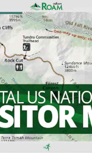
•Public Lands: Nationwide Federal and State (the most accurate and complete nationwide dataset ever created)•City and County Open Space•Trail and Trailhead locations, names and numbers•Geographic and Recreational Point of Interests•Water Data•Weather and Radar•Campgrounds and secluded Campsites•Ski runs and lifts•National Park Service Visitor maps•National Forest Visitor Maps (save thousands $$$ on paper maps!)•Motor Vehicle Roads and Trails (MVUM) displaying National Forest System (NFS) Routes (roads and trails) open to motorized travel•Nationwide USFS Roads•Nationwide USFS Trails and Wilderness•USGS Gage Stations•USGS Snotel (snowfall measurements)•Wildfire Historic Perimeters•Active Fires•Private Landowner Names with Property Boundaries•And much more!▶ BASEMAPS•USGS Topo (Quads)•Aerial Imagery•Imagery + Topo Hybrid•OpenStreetMap•World Topo•World Imagery•World Streets•USA Topo Maps•Ocean BaseMap
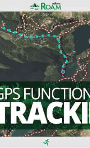
▶ GPS Functionality Right on Your Phone or Tablet•GPS Location•Mark Waypoints•Tracks•Compass Mode•View elevation profiles•Backtrack function to make sure you can always make it back to the vehicle safely
▶ TRACKING FUNCTIONALITY•Active track on/off•Track elevation profile
▶ MARKUPS AND DRAW TOOLS•Place Points on the map•Geotag Photos•Use Custom ROAM Waypoint Symbols•Draw Lines•Draw Shapes
▶ MULTIPLE DEVICES (my.onxmaps Cloud sync):•ROAM anywhere! One account gives you access across multiple devices•2 devices
- Use on your phone and tablet•New phone? No problem. Simply log in to your account and access all your map content that is automatically saved to your account•Your tracks, photos, waypoints and maps are automatically synced to all your devices•Waypoints are automatically saved to the cloud. No more risk of losing your valuable waypoints if you lose your GPS or change phones
▶ SHARE VIA SOCIAL, TEXT, OR EMAIL•Tracks•Markups
▶ MEASURE TOOLS•Distances•Perimeters•Areas
▶ SEARCH•Search for nearby places•Points of Interest•Landowner Names
▶ AUTOMATIC MAP UPDATES•The newest map data is automatically streamed into your device with no cumbersome update process
▶ ‘USE SAVED MAPS’ MODE•Forces the app to use your saved maps when in areas of low cell signal•Saves on battery life
Note: As with all mapping apps, continued use of GPS running in the background can dramatically decrease battery life.
Category : Sports
Reviews (27)
Resubscribed and not as happy as I was last year. Roads/trails flicker in and out. Saving offline maps turned in to a pain in the rear. Doesn't seem as streamlined as last year subscription. Update needed. *Edit* 8-7-17... Just finished with our groups annual Magruder Corridor trip and had to uninstall/re-install after it glitched and crashed my phone again. Erased ALL of my saved maps that took me hours and hours to download throughout the last 3 months +. Really frustrating after having many of my friends buy OnXmaps.
Would not let me set up a account. Tried for 3 days got tired of trying uninstalled.
Crashes every second operation (I.e. map opens, but access a menu item and it crashes). HTC One M9, with NV subscription and Annual subscription.
I switched from a paid version of Backcountry Navigator, which has a real awkward interface. This is easier to use.
Rip off, paid 10 bucks and get regular messages to upgrade to premium, maps don't download for offline use. They basically took my ten bucks and flipped me off.
Well, you got my ten dollars and didn't activate the paid features. Nice work. It even shows I don't renew for another year but nothing works. Real nice
Out of all the maps and gps and Google earth and around me apps this is by far the best I live in the desert mine shafts everywhere some with notice and fences others with none this app shows the mining districts the back roads multiple base maps and overlays so much other apps don't have it takes takes awhile to load maps but we'll worth it
On some of the base maps, there is no way to tell which tiles are already saved. They go back to green even when saved.... Update 2-17-17- still waiting for this bug to be fix. I love the app but this issue really limits the the practicality of most of the bass maps.
FALKEN TIRE CO INC
Loved tHis app. Helped me find great spa to camp and get blitzed
This is one of the better one to use for hunting or just out for a afternoon stroll thru the brush. it works
Great tool
A decent gps for trails. Takes a bit to get used to, but overall a nice offline map system. Maps are highly detailed and worth the yearly subscription fee. I would like to see a more user friendly offline tool. Sometimes it isn't exactly the area intended. Maybe allow an entire county to be loaded up instead of a blank search and save. Would be handy for search and rescue.
I think it's kind of bogus that I have to pay 10 bucks to use the app, and then an additional 20 dollars to use the private parcel feature. And not to mention it doesn't even have up to date info and not even all the counties show up. Talk about getting screwed.
I have a galaxy 7, I really want to like this app, my friend has it and loves it. The maps just take too long to load on my phone.
I hunt by myself a lot, so it was really nice knowing I could feel better about going further into the woods without getting completely turned around.
Downloading is agonizingly slow. Paid the money but it takes forever to download the maps. When you cough up and buy better servers or bandwidth I would give you a five. Can't plan a spur of the moment trip because the maps take forever. Good idea but not ready for prime time.
Excellent app, worked very well for locating my destination points. I appreciate the fact they are actively developing and improving features to meet their customer needs. Downloads for offline use are a little slow but I’m sure as more people use this app they will improve the speed. I appreciate the level of detail that can be downloaded. The membership fee is reasonable, my other mapping software (strictly PC based) also has a yearly membership fee. It is nice to have the option whether or not to purchase the land ownership layer.
Signed up for account and can't log in. Deleted it right away and will use AllTrails Pro.
This app is awesome. If you like to hike, this is a must have. Detailed roads and trails. So many features, it is a bit overwhelming at first, but once you get it down its so easy to use. Great for planning hikes and dicovering new areas. Love it!!
The topo map and GPS seem to work ok but downloading and using trail maps (the big selling feature) was slow. The trail layer disappears often as you pan around the map. I wouldn't trust this in the field.
Paid downloaded tiles for hike up South sister Oregon. Not there when off line. When I try and contact app indicates I am off line when not.
Only american maps and very hard to understand how to use it..other apps are better...without european maps this app is nothing worth for me..im sorry!
Slow to load maps even if saved area and on wifi but great concept
takes toon long to download, and wont download in the background.
I really like this app. Working good on my Moto X 2nd generation phone. Has great details in multiple map sets. Price is on the opening page, so I don't see how someone would rate this down for having to actually pay people for creating something so useful.
loved app initially. Upon downloading received a 7 day trial period for upgrade version.Was offered additional 7 days if I text and advertise app to 10 contacts,family/friends. I did so, now had 14 days trial.Upon using app, I really liked it, seemed as advertised.however, 3 days into the 14 day trial,it said I had 11 days.would no longer log in or let use app.now, today,7 days into trial it says trial has ended and wants me to pay to upgrade.3 days simply wasn't enough to evaluate.feel tricked mislead