Satellite finder 2020
SatFinder (Satellite Finder) Geo area calculator and Level meter is a tool which will help you to set up satellite dish. It will give you azimuth, elevation and area calculation for your location (based on GPS) and chosen satellite from list. The result is shown both as numeric data and graphical on google maps. It has also built in magnetic compass which will help you to find proper satellite azimuth.
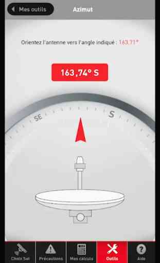
Finding a TV satellite or an antenna, in azimuth can be pretty difficult. Before you can find it with a compass you have to do some calculations using GPS location, magnetic variation, compass azimuth and satellite azimuth.
Bubble Level – Inclinometer
Best Level functioning the same as its real physical equivalent (also known as libella, spirit level or bubble level). Using it you can easily check if the measured surface is truly flat. An inclinometer or clinometers is an instrument for measuring angles of slope (or tilt), elevation or inclination of an object with respect to gravity. It is also known as gradient meter, gradiometer, level gauge, level meter, declinometer, and pitch & roll indicator, quick satfinder, satellite detector, satellite finder, satellite direction, ISS Detector Satellite Tracker,
satellite director dish & satfinder app.
Geo Area Calculator For Land
Field area measurement app is a free area distance and perimeter measurement app also referred to as GPS area calculator for land measurement,to measure area on map, or platometer and is used to measure field areas, collect ground samples, GIS surveys. This app act as fast area distance marking
Features Of Satfinder (Dish Pointer) Area Calculator:
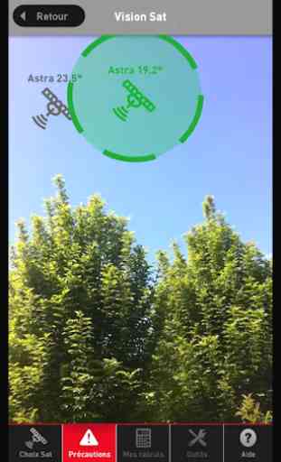
- Satellite view above your location where to point the dish
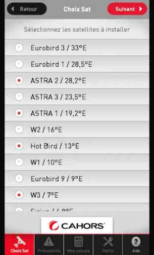
- More Than 150 Satellites available worldwide
- vibrate on finding exact direction
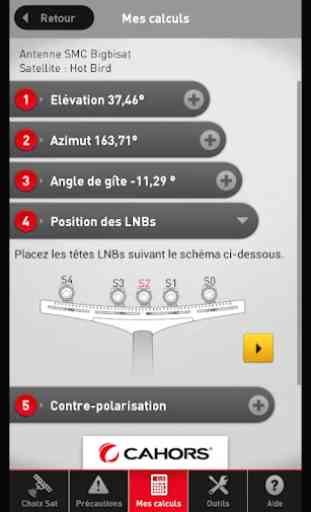
- Display your location and all satellites the values for: azimuth, elevation
- Accuracy of measurement with Bubble Level
- 3 different display modes of Level Meter
- Spirit Level, bubble level, electronic level, laser level, nivel, plumb bob, level tool, clinometer, leveler, protractor, inclinometer, carpenter's level
- High Accuracy with fast area and distance marking
- Land Based Surveys
Finding a TV satellite or an antenna, in azimuth can be pretty difficult. Before you can find it with a compass you have to do some calculations using GPS location, magnetic variation, compass azimuth and satellite azimuth.
Bubble Level – Inclinometer
Best Level functioning the same as its real physical equivalent (also known as libella, spirit level or bubble level). Using it you can easily check if the measured surface is truly flat. An inclinometer or clinometers is an instrument for measuring angles of slope (or tilt), elevation or inclination of an object with respect to gravity. It is also known as gradient meter, gradiometer, level gauge, level meter, declinometer, and pitch & roll indicator, quick satfinder, satellite detector, satellite finder, satellite direction, ISS Detector Satellite Tracker,
satellite director dish & satfinder app.
Geo Area Calculator For Land
Field area measurement app is a free area distance and perimeter measurement app also referred to as GPS area calculator for land measurement,to measure area on map, or platometer and is used to measure field areas, collect ground samples, GIS surveys. This app act as fast area distance marking
Features Of Satfinder (Dish Pointer) Area Calculator:
- Satellite view above your location where to point the dish
- More Than 150 Satellites available worldwide
- vibrate on finding exact direction
- Display your location and all satellites the values for: azimuth, elevation
- Accuracy of measurement with Bubble Level
- 3 different display modes of Level Meter
- Spirit Level, bubble level, electronic level, laser level, nivel, plumb bob, level tool, clinometer, leveler, protractor, inclinometer, carpenter's level
- High Accuracy with fast area and distance marking
- Land Based Surveys
Category : Tools
Related searches
Reviews (5)
Iso. g.
Jan 4, 2020
It is a very good satellite finder
Moh. A.
Sep 9, 2020
Perfect 👌 I really love it
RAK. K.
Aug 10, 2020
Bad app almost
Mit. P.
Aug 8, 2020
Best
Very nice app technology for solution finding satdish and direction set up