
Sheltowee Trace Trail
Thru-hikers, day hikers, volunteers, friends and family, future hikers, or arm-chair hikers and trail enthusiasts will all find something useful.
For Hikers:
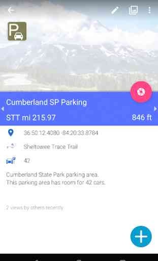
• Most up-to-date trail and town data crowdsourced by thousands of hikers. See water reports, snow conditions, stream crossing water levels, bus schedules, restaurant and lodging reviews, and more.
• Any user can add waypoints, photos, comments, update descriptions, and edit any content in the app, in real time. Think Wikipedia!
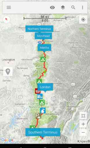
• Download topo maps, road maps, and satellite images for offline use.
• Navigate using GPS while in Airplane mode. Everything in the app works while offline after the initial data download.
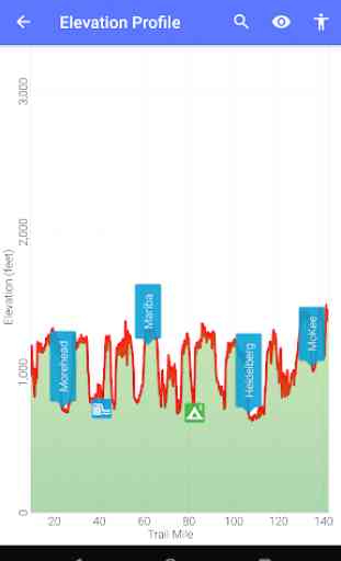
• View elevation profiles and compute distances to locations along the trail.
• Share your location (optional) and see where others are on the trail.
• See a real-time feed of contributions other hikers are making.
• Search the map by name or point type, search the activity feed by hiker name, location, or type of edit.
For Friends and Family:
• Track the location of your hiker on the trail.
For Trail Maintenance Crews and Land Management Agencies:
• See real-time hikers reports of trail damage, blowdowns, and infrastructure maintenance needs (e.g., washed out bridges).
For Future Hikers and Trail Enthusiasts:
• Explore and learn about the trail. See current photos, use the wealth of information and hiker reports to plan your hike and resupply stops.
The Sheltowee Trace Trail is part of the HikerBot family of apps. We also have apps for the following trails: Appalachian Trail (AT), Pacific Crest Trail (PCT), Continental Divide Trail (CDT), John Muir Trail (JMT), Sierra High Route (SHR), Great Divide Mountain Bike Route (GDMBR), Continental Divide Singletrack Trail (CDST), Hayduke Trail (HDT), Wonderland Trail (WT), Arizona Trail (AZT), Pacific Coast Trail.
Category : Travel & Local
Reviews (7)
very bad, do not install. maps are not accurate to trail will tell you you're way off trail when you are touching a blazes. could put you in more danger than having nothing. tried to give feedback to company and they said not their problem. i would never recommend this to anyone.
It took 3 days to download the maps but it finally completed the download. But I still can't sign in. I'm using the original Pixel phone. Please help. I would love to use this app for my hike.
Wow, thought i got lucky and found an app for.my upcoming FKT, fat Chance. Maybe guthook will get in on this trail, now thats an app worth using. I wouldn't give a damn if it coat $70 if it was even half of what guthooks is.
Waited over a week for the "download" and nothing happened. Still no maps. Completely useless.
has potential but way too many bugs and is virtually useless unless you spend cash
Can not log in or access trail, can't contact server.
You got a trail map that doesn't show the trail, won't connect to server, and doesn't seem to have any features advertised. I'd say you were running a scam, but the app is free. Whatever, man. If you aren't going to have a working app, take this piece of hot garbage off the app store at least. It's free, so it ain't stealing, but that doesn't mean it ain't lying.