Ships and Vessels
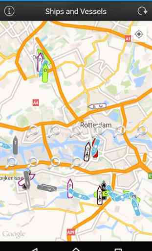
This app presents allows users to locate ships and vessels live on a map. Just open the app, let it find your location and press the refresh button.If any ships nearby with appropriate AIS transponders and a receiving station in our network is picking it up you should be able to see the ships on the map.
See the following ship/vessel details:
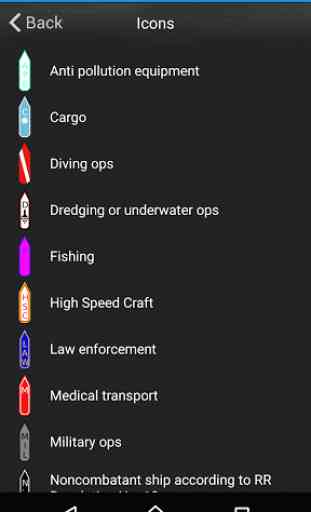
Update timeMMSI numberIMO number (Internation Maritime Organisation)Ship Type (Passenger, cargo, pleasure, dive, military and many more)
Navigational status (under way, berthing, moored and many more)Rate of Turn (when available)Speed (kts)CourseTrue HeadingSpecial ManeuvresLatitude and LongitudeDestination port (call of port) when availableETA (Estimated Time of Arrival) when available
Vessel Length (meters)Vessel Width (meters)Vessel Draught (meters)To Bow (from AIS transponder)To Stern (from AIS transponder)To Port (from AIS transponder)To Starboard (from AIS transponder)
We hope you enjoy the app please leave a good rating in order to keep us improving the app.
See the following ship/vessel details:
Update timeMMSI numberIMO number (Internation Maritime Organisation)Ship Type (Passenger, cargo, pleasure, dive, military and many more)
Navigational status (under way, berthing, moored and many more)Rate of Turn (when available)Speed (kts)CourseTrue HeadingSpecial ManeuvresLatitude and LongitudeDestination port (call of port) when availableETA (Estimated Time of Arrival) when available
Vessel Length (meters)Vessel Width (meters)Vessel Draught (meters)To Bow (from AIS transponder)To Stern (from AIS transponder)To Port (from AIS transponder)To Starboard (from AIS transponder)
We hope you enjoy the app please leave a good rating in order to keep us improving the app.
Category : Maps & Navigation
Related searches
Reviews (5)
Gar. S.
Jun 1, 2017
Worthless. Don't waste your time.
Cha. N.
May 27, 2017
Findship has not been download
MD8.
Feb 27, 2016
This app sucked
Jay. B.
Jan 5, 2016
Nothing to find vsl
Needs to be updated