

ShowMeHills AR mountain peaks
- see link below).
When you look at the landscape using the camera labels giving the mountain names are superimposed directly over the view. The labels can show the distance to the mountain peaks, the bearing, and the height of the mountain. Clicking on a label shows information on the peak with a link to more information (if you have internet access
- the rest of the app works fine when you don't!).
Useful for walking and hiking when you want to know the names of the hills and mountains you're looking at!
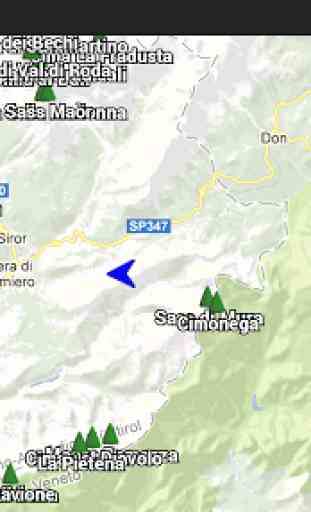
You can switch to a Google Map view which also shows the peaks, plus your location and direction of view.
Show Me Hills is an experimental application that is extremely dependent on your GPS location and handset's compass bearing. If either are inaccurate then the names will appear in the wrong positions. Since the compass on many handsets is very unreliable this can prove frustrating
- the application does have the feature to offset the bearing of the compass which can help, and doing the figure of 8 compass calibration can help as well. There are also user options for tweaking the smoothing of compass readings.
While using the camera view you don't need Internet access, but if you switch to the Google map view you'll need it for the maps.
The mountain peak database has been extracted from OpenStreetMap by Mayeul Kauffman
- an amazing job, taking the number of peaks from hundreds to almost third of a million!
The app can be moved to the SD card if required, although the database is only about 10Mb, so it's not as large as you might imagine.
UK only version: https://play.google.com/store/apps/details?id=com.showmehills.showmehillsuk
This is a free open source application released under the GPLv3 license, and developers are welcome to contribute at https://github.com/ShowMeHills
If you come across any problems, please report to the email address: [email protected]
Future plans:
* filtering by prominence
* keep on improving the dataset
* allow photos to be taken with the names
* allow users to report their position to OpenStreetMap
* alternative apps using the same technology (ie a ShowMeTowns type app)
Category : Travel & Local
Reviews (14)
it is useful app
VERY awkward compared to either PeakFinder or PeakLens. The labels jump and flicker constantly, and regardless of this it is hard to identify which peak it belongs to. The free PeakLens app works flawlessly, and the pay-for PeakFinder is the best, imo (although PeakLens might be easier to use).
Looks like a great app, but my cheap phone (galaxy core prime) does not have a compass sensor :(
this is a great help to identify peaks - filter by distance & height to focus on an area -
Allows you to work out mountains and hills in the distance. Great communication with author too.
Seems to work except the camera is upside down. Is there a setting to flip the view?
This is a great start and I'm really looking forward to future improvements. The ability to take screenshots of the view will be nice. Even just being able to freeze the view would be helpful. I'd like to see some preferences build in so the font color/size can be changed. On a cloudy day the white font is hard to read in camera mode. What I'd really love to see is the ability to capture a scene, recall it later and be able to interact with it. If I could zoom into a picture and see the names appear on more distant peaks as I zoom towards them in the picture, that would be pretty cool.
After I got the calibration correct it was dead-on accurate and could identify even the smallest Hills on the horizon. Well done!
Now I know the names of all those hills around me.
Great app to help orientation when in hills.
[updated: the database problem has been fixed (very quickly)] The introduction text is really too long for such a simple app. Should just directly display the calibration the first time and the user can read the help text later if he wants to. The FOV calibration should make it more clear that there is a red band on the border. Didn't notice it first. In addition once you've tapped, the text should update (to say that the second part of the calibration is going on), to let the user know that the tap was registered. Unfortunately, it seems my phone doesn't have enough RAM for the app to run smoothly so I couldn't test it further. Nevertheless the idea seems good and it's open source so I give 3 stars :-)
The compass did not work. I have other apps that do work, so this is not my equipment.
Not working or too confusing with lebanese mountains and hills. Not efficient...
Blank screen after start, that's it