SinkMap
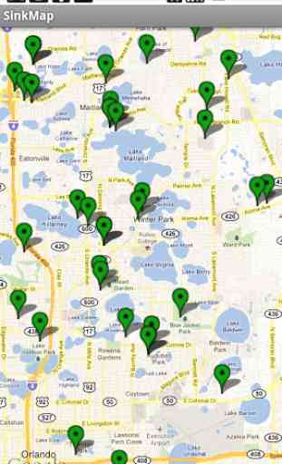
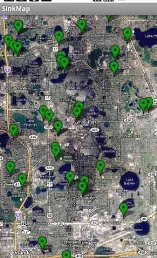
SinkMap™ is a map application that displays the location of sinkholes and other reported subsidence events in the state of Florida. Tapping on a green marker on the map will display select data from the subsidence incident report for that location.
FEATURES
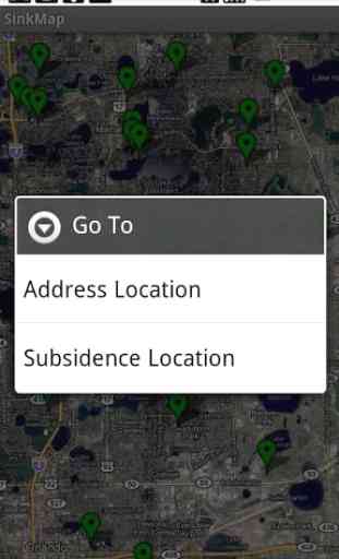
Map with optional satellite viewMarkers showing location of reported subsidence incidentsCurrent location marker and compassGeocoding (Go To) addresses and municipalitiesGeocoding for subsidence locations via reference number
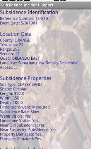
SUBSIDENCE INCIDENT REPORT LOCATION DETAILS
• Event Date
• County
• Township
• Range
• Section
• Quad
• Land Use
• Access
SUBSIDENCE PROPERTIES
• Soil Type
• Shape
• Length
• Width
• Depth
• Dimension method
• Subsidence rate
• Water visible
• Limestone visible
• Near old subsidence event
• Near suspected subsidence
• Property damaged
• Damage repaired
• Subsidence indicators
• Subsidence triggers
GETTING STARTED
• Launch the app and navigate to a city by pressing the menu button, tapping the "Go To" menu item, tapping the "Address Location" menu item, entering the desired city in the prompt dialog, and then tapping the "Ok" button. The map should center on the city entered in the dialog.
• Zoom in and out on the map by using the zoom buttons (visible when the map is touched) or by using pinch and reverse pinch gestures on the touch screen of your device. Note that subsidence indicators (green markers) will only be displayed if the zoom level on the map is sufficiently high to limit the number of markers to a count of ~250 (for instance, markers will not be shown if the entire state of Florida is visible on the map).
• To view the subsidence incident report for any marker displayed on the map, simply tap the marker. Select details from the subsidence incident report will be displayed. Scroll down on the report screen to see more information. When finished reading the report, press the Back button to return to the map.
Note Regarding Feature Image
The background picture of the large sinkhole in the feature image is credited to (and courtesy of) the Florida Department of Environmental Protection, Florida Geological Survey, and depicts the famous sinkhole of Winter Park from 1981 (reference number 75-510).
Notes Regarding Subsidence Data
The data set used in SinkMap was created by the Florida Department of Environmental Protection, Florida Geological Survey, and is available free of charge in Microsoft Excel and ESRI shapefile formats. The web page where this information can be located is:
http://www.dep.state.fl.us/geology/geologictopics/sinkhole.htm.
SinkMap is not endorsed by, and is not affiliated with, the Florida Department of Environmental Protection, Florida Geological Survey. The author assumes no responsibility for errors in this information and does not guarantee that the data is free from errors or inaccuracies. Similarly, the author assumes no responsibility for the consequences of inappropriate uses or interpretations of this data. As such, the data set in this app is distributed "as is" and the user assumes all risk as to its quality and the results obtained from its use. The author bears no responsibility to inform users of any changes made to this data.
FEATURES
Map with optional satellite viewMarkers showing location of reported subsidence incidentsCurrent location marker and compassGeocoding (Go To) addresses and municipalitiesGeocoding for subsidence locations via reference number
SUBSIDENCE INCIDENT REPORT LOCATION DETAILS
• Event Date
• County
• Township
• Range
• Section
• Quad
• Land Use
• Access
SUBSIDENCE PROPERTIES
• Soil Type
• Shape
• Length
• Width
• Depth
• Dimension method
• Subsidence rate
• Water visible
• Limestone visible
• Near old subsidence event
• Near suspected subsidence
• Property damaged
• Damage repaired
• Subsidence indicators
• Subsidence triggers
GETTING STARTED
• Launch the app and navigate to a city by pressing the menu button, tapping the "Go To" menu item, tapping the "Address Location" menu item, entering the desired city in the prompt dialog, and then tapping the "Ok" button. The map should center on the city entered in the dialog.
• Zoom in and out on the map by using the zoom buttons (visible when the map is touched) or by using pinch and reverse pinch gestures on the touch screen of your device. Note that subsidence indicators (green markers) will only be displayed if the zoom level on the map is sufficiently high to limit the number of markers to a count of ~250 (for instance, markers will not be shown if the entire state of Florida is visible on the map).
• To view the subsidence incident report for any marker displayed on the map, simply tap the marker. Select details from the subsidence incident report will be displayed. Scroll down on the report screen to see more information. When finished reading the report, press the Back button to return to the map.
Note Regarding Feature Image
The background picture of the large sinkhole in the feature image is credited to (and courtesy of) the Florida Department of Environmental Protection, Florida Geological Survey, and depicts the famous sinkhole of Winter Park from 1981 (reference number 75-510).
Notes Regarding Subsidence Data
The data set used in SinkMap was created by the Florida Department of Environmental Protection, Florida Geological Survey, and is available free of charge in Microsoft Excel and ESRI shapefile formats. The web page where this information can be located is:
http://www.dep.state.fl.us/geology/geologictopics/sinkhole.htm.
SinkMap is not endorsed by, and is not affiliated with, the Florida Department of Environmental Protection, Florida Geological Survey. The author assumes no responsibility for errors in this information and does not guarantee that the data is free from errors or inaccuracies. Similarly, the author assumes no responsibility for the consequences of inappropriate uses or interpretations of this data. As such, the data set in this app is distributed "as is" and the user assumes all risk as to its quality and the results obtained from its use. The author bears no responsibility to inform users of any changes made to this data.
Category : Books & Reference
Related searches
Accuracy of pinpoints are as accurate as GPS I believe. One sink at intersection near my old house is off by several hundred feet or more. But, still gives good info. I only want to know why two sinks have not been reported years ago that happened near where I live now. Worth a dollar!