SityTrail France - hiking GPS
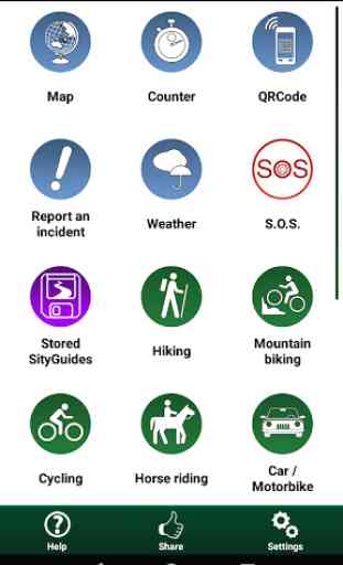
Here are its main functions:
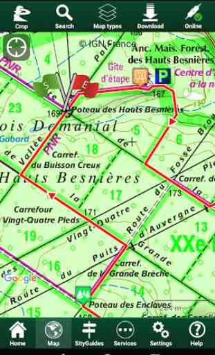
★ IGN FRANCE TOPOGRAPHIC MAPS IN YOUR POCKET
All the topographic maps you need to discover France, Corsica and Overseas departments and territories on foot, cycling, horse riding, or by car, motorbike or quad.
Subscription charge: The application can be accessed for free for a week’s trial. You may then take out a subscription for €24.99 per year or €11.99 per month, all-inclusive.
Tourism and discovery
Discover the new 1:25 000 IGN map ideal to (re)discover an area on foot, bicycle, horseback or car. The series includes coverage of mainland France, Corsica and Overseas departments and territories representing all relevant information for outdoor activities: roads, trails, streams, tourist sites, shelters, rest houses, buildings, religious buildings, ...
The Grandes Randonnées
The GR ®, maintained by the French Federation of Ramblers, are also displayed: 60,000 km of hiking trails! Also shown on the maps are the PR ® (petites randonnées) shorter walks for a day.
★ MAPS AND YOUR WALKS AVAILABLE IN OFFLINE MODE
The download tool lets you get the most out of your maps and routes on the ground without any internet connection.
There is an alarm when you stray from the route being followed. No more need to continuously check your smartphone, this alarm system will stop you getting lost or having to turn back on yourself.
Automatic activation of points of interest and text to speech synthesis.
An elevation profile that enables the visualisation of inclines and of any difficulties along the route.
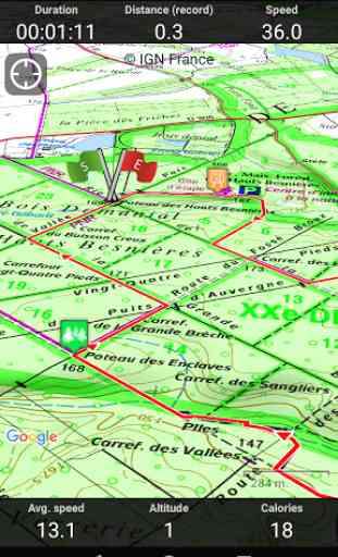
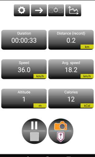
★ RECORD YOUR ROUTES WITH PHOTOS
Record your walks in real time on the ground, and create points of interest with your own photos and commentary.
Display showing distance covered, time taken, average speed, GPS altitude, inclines (+/-), and many other useful indicators for walkers and mountain bikers.
Estimate of distance and time remaining based on your average speed.
Elevation profile for the current recording.
★ CREATE AND SHARE YOUR WALKSWith our online editor, create your own walking projects using an internet navigator on your PC/MAC and then accessing them directly from your mobile to experience them on the ground.
Go further. Transform your favourite walks into real multimedia guides with text, photos, video links, and share them with the SityTrail community.
Access too to thousands of walking circuits from other members and let yourself be guided!
★ TOURIST ATTRACTIONS AND WEATHER SERVICE
Get plenty of localised tourist information: articles Wikipédia, accommodation, restaurants, and various services such as chemists and banks.
Save your favourite places so you can consult them during your trip.
Check on the five-day weather forecast for any location on the map to help you organise your stay.
★ ADDITIONAL FUNCTIONS
Easily create points of interest, such as the location of your car, your hotel, or a restaurant.
In the event of any problems, the SOS function enables you to send your GPS coordinates to your contacts.
Geocachers can use the compass to find their way to a geocache.
★ ANDROID WEAR SMARTWATCH
- Route and GPS position visualisation.
- Indication of distance covered and remaining.
- Arrow display indicating the direction to be taken.
- Alarm when you stray from the route.
We wish you lots of fun with SityTrail France.
Application Manual: http://www.sitytrail.com/lang-en/manuals_trail.htmlFor any questions or suggestions: http://www.sitytrail.com/lang-en/support_trail.html
-
-
- Some functions need an internet connection. The prolonged use of GPS can reduce battery levels.
Category : Travel & Local
Reviews (25)
I have been happily using the app for many years, but the current version is terrible. Not intuitive, no gpx export, no interesting plots. We are back to the level of the worst hiking apps in the previous century. No clear incidents, has just become useless. May be some new/promised gadgets like hotel reservation are of interest for some users. I need an app to actually hike.
Redone but gone live too soon? I've happily used previous version for many years. New version seems more limited and less reliable. Also changes interface and map downloads. I'm adapting and slowly solving issues. Main issue left is that app can (seemingly) no longer open gpx files. Must do this instead on web. Also slow to change between maps. Another issue: settings for silence don't always work. And can't see area covered by downloaded maps.
Worthless app. Gives you an option to try a free trial after creating a new account, but when trying to activate the 7 day free trial it tells you your new account is ineligible for the free trial. The paid premium version can only be bought for one year, no options for just one week/month so it would be useful or holiday hiking
App does not work without a subscription. It offers a 7day trail, but when you hand over your personal information, it simply tells you no... No idea if the app is convenient or stable. Does not inspire confidence to actually take out a subscription, only to find out it still doesn'twork...?
I used to have the GR app without being warned it changed to Sity Trail. Far more expensive. Not intuitive to use . It does not recognize my password anymore. I just want to use the QR code as I used to do and start my walk. Now I've been trying out already for half an hour why it does not let me log in. I'm furious. I contacted their customer support a while ago. Never had a reply. Please give me back the straightforward app from GR for a fair Price.
It does not work, subscription needed before you can do anything. False ad
What can you actually do with this app? I just downloaded it to find some local trails, I can not open the maps and follow them. What's the point?
Asking too many totally unnecessary permissions at the very beginning and quitting otherwise.
Opened the app for the first time. It's half French. Translate your thing before asking for money.
Requires a 25€ subscription to guide you along publicly signposted walks
Not working on older versions of Android.I can no longer use this app which is a shame because it was very good. EDIT - I already contacted you and you said it does not work with older versions. You only want to talk to me in private so people won't know what you have said. EDIT - Nice try, it's 4.4.2 actually on Samsung GT-P5210.
Always claims no internet connection even when next to the router. Not much good
Crashed 3 times within first minute...
I've used these maps on a few trips to France, and found them excellent. The 1 25000 maps have allowed me to use some very minor roads and chemins. All works reliably.
I have been using this for some weeks. You download the IGN hiking maps you need for the region you are hiking, cycling etc. Then you can use them off line. Choose your region then select the hike you want from the many uploaded. Start your hike and your progress is tracked. Go off course and you are warned. Tech support is prompt and helpful in French and English.
I started using this back when it was called Geolives and the maps were good and accurate. Since the name change, I've had some issues with the maps not zooming properly or not showing all the trails you can see on the paper IGN maps. I'm hoping for some newer updates soon that will help resolve some of the mapping issues.
Does what needs to, however downloading maps is slow.
When this used to be called Geolives, although the mapping component worked brilliantly with IGN maps, the whole subscription and account management service was very confusing and it wasn't clear which company you were dealing with and the website was quite muddled up and inconsistent. Unfortunately this has recently got worse now that the product appears to have changed its name to 'SityTrail' (even though it's primarily for use outside of cities ?!) and the Android App account doesn't mirror the web based account. There doesn't appear to be any configuration of this App. As soon as it opens it's stating that I have no subscription despite me having paid for one via the phone App (my PayPal account confirms that I've paid GeoLives !). Not surprisingly if I view my account via the web it doesn't recognise that I've made payment either. Overall, this is a bit of a mess, which is a shame as the Geoportail service is class leading and turns a decent phone like an S2 into a very useable sports GPS device. I might update this message if the developers improve things a bit - they can start by telling me where my Paypal payment has gone !
For 15€/year I'm surprised that Geolives doesn't have a reliable content delivery system. I struggled with slow speeds - downloading 81Mb (15km offline maps) took between 1-1.5 hours - average download speed between multiple tries is about 15KB/s!!!! Even scrolling around on the map takes about 10 seconds for the few visible tiles to be loaded. Normally the above would be OK if left to run overnight; however they have an annoying alarm that keeps ringing once the download is done... woke everyone up!
Used app while on holiday to navigate on my mtb. Can't fault it.
Fantastic tool for accessing French ign walking maps. Easy to use. Helpful website in French.
not clear how to buy it
Seems to be a good start, now needs finishing. Maps don't rotate, you get a beam on the map, showing your direction. Zooming in shows some weird map, not the IGN map... Google does better! Shame... Could be much better. Oh, and it crashes a lot on HTC X One
Installed app then subscribed for IGN maps for a month (something like €5). Spent a bit of time downloading maps of relevant bits of France, at range of scales, then used them when on holiday. Well worth the time and effort.
Disappointing world maps. The official trails (GR, GRP, PR) are not indicated unlike what is advertised. It is only the records of individuals' hikes, which may be quite different from the official trails. Moreover, to see these markings, one needs to zoom in to a scale of 1:25000, which isn't useful to get a big picture of the trails.