Sketch a Track - GPX Viewer
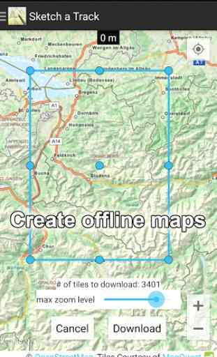
Offline maps
* can be generated to use the app without an internet connection.
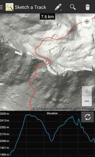
GPX is a commonly used file format to exchange GPS track data. You will find a lot of hiking or mountain bike tours in this format on the internet
'Sketch a Track' is an easy to use GPX creator. You can create and edit your own GPX files to share them with others.
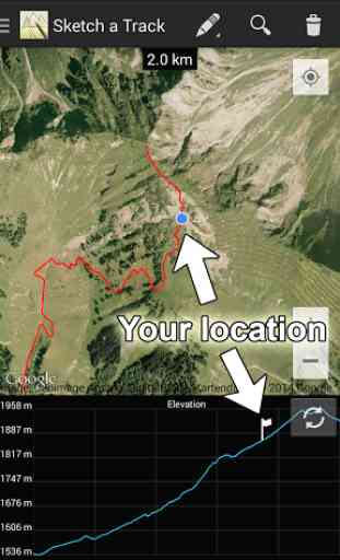
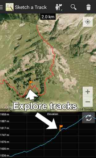
Tracks can be imported, exported, drawn, erased or explored. Exploring means that you can move across the track and the corresponding location is marked in the elevation chart.
Also your location is displayed on the map as well as on the elevation chart when you are close enough (within a radius of 100 meters/330 ft) to the track. Imperial as well as metric systems are supported.
A track can consist of several segments. A new segment can be started by pressing the S Pen side button while hovering on the screen.
'Sketch a Track' is optimized for devices with an S Pen, but also a great tool on other devices.You have a Samsung Gear? Then also have a look at 'Sketch a Track for Gear'!
In the trial version you are limited to save up to three tracks but you can unlock the full version within the app. The full version also let's you export your track to GPX and allows you to create offline maps*!
(*) the offline maps feature is temporarily disabled caused by changes of our previous map tiles provider
Category : Health & Fitness
Reviews (26)
Amongst all similar apps, this one is the closest to being good enough, but not quite yet! A tool tutorial would be nice. The straight line tool don't seem to work. As soon as I touch screen after selecting straight line to, it reverts back to the manual input tool with squiggly lines. The way point to don't seem to work either. It shows a flag when touching the trail already drawn but disappears a soon as fine is lifted. Can't seem to be able to set any way point whatsoever.
Promising, for sure. Imagery really good, very easy to transition to this app if you are familiar with ARCgis or GE. update* I feel as though drawing a line has become much more difficult then it was prior to update. I don't have the freedom I once did. The line will stop abruptly and The pencil will be shaded dark on one end and light on the other. But trying to resume with either end doesn't seem to work.
Nice but not quite there yet..excellent UI that makes it easy to plot a route for myountain runs, but REALLY needs a way to edit plots to fine tune and a "snap" to road (in my case trail) feature to make easier. Don't mind a subscription, but currently at $7.99 it's a turn off, would jump on if a little cheaper at $4.99. Need to really test out exporting also to test with my Coros Apex watch, but have to subscribe to do that (even though there is a 14 day trial)..
Recurring subscription fees to bleed users dry ad infinitum, without any possibility to purchase the software once and for all. Why do developers not offer both options, especially when there are so many superior competitor products that do, or at least disclose the rip-off scheme in detail in the 'About' description, so that one does not waste time with subscription-based (cr)apps? This milkingware has been uninstalled, replaced with two better alternatives that can be bought instead of rented.
Great for customizing your own routs and saving them along with a general idea of total elevation change. Great job on keeping the 3 maps up to date adding different routs and colors. Would be a 5 STAR if the total elevations was more accurate in hiking in different situations.
The elevation feature is not working, and that is why I paid for the app :( how do I fix it?
Quick and easy route plotting app. The incremental updates have been useful, the last one which means you no longer have to swap between draw/move modes is brilliant
Hi, I can't seem to export gpx, just gives a link to the map on the app. In other words my 3rd party app can only read gpx and is not reading the export this app is sending out..is there a setting I need to change?
Buggy rendering, must switch between map layers to get something shown. Otherwise the map is often not rendered at all and the screen is blank
Slow map, unable to specify route by point via specified vehicle type. But worst of all: extra slow!
Finding some excellent features for drawing a combination of off road and road routes.
I'm really not gonna subscribe... A one off purchase then yes, but a subscription is not necessary... Too many apps are subscription based now with no real good reason
Excellent app, I've used it this summer for navigating Munro's, very easy to use, impressed!
This app is pretty easy to use. I would definitely purchase it if it wasn't a subscription model.
Great app, easy to use. Developer very responsive to feedback
Needs the USGS maps. Can't draw a route if I can't see the trail, I want to draw
Awesome! Exactly what I was looking for.
Best on the market works very well!
Perfect to draw my planed routes.
Very limited editor
Great with Galaxy Note
Easy to use
Does the job.
Very good app! I wouldn't use it enough to justify paying a yearly fee, but that's my problem. Very easy to use. I take one star, because of the very limited choice of maps.
Absolutely fantastic app for discovering new running or hiking routed no matter what country I'm in (so far only tested across Europe though). Haven't been able to find any other app as useful as this.
It's a really good game but not that much everyone I get a new map it lags and it dosent work I go in the map again it dosent work also the lines don't unite