SkyDemon
Use this app to access your SkyDemon subscription on your Android device, unlocking SkyDemon's powerful features while on the move.
FLIGHT PLANNING FEATURES
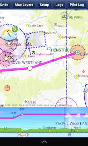
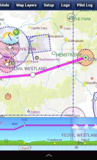
- SkyDemon vector charts are the clearest aeronautical charts you'll ever use, with dynamic airspace clipping and choice of map layers
- Route planning is as simple as touching consecutive waypoints and dragging to make changes
- Virtual Radar shows how your route relates to airspace, terrain, obstructions and other features
- Pilot Log facility calculates headings and groundspeeds from actual wind data, and shows useful frequencies
- Plates and other documents for relevant airfields are displayed automatically as you plan, and many are available georeferenced for use in flight
- Intuitive pan, pinch and rotate support with no loss of map clarity or text legibility
- File a VFR flightplan for your route directly to air traffic controllers
- Automatic TAF, METAR and SIGMET briefing as you plan a route, with graphical decoding
- Rainfall data can be overlaid on the main map, with animation, showing the trend of rainfall over time
- Integration of GAFOR route forecasts for Switzerland, Austria, Slovenia and Croatia
- Both narrow-route and area NOTAM briefings available, updated as you plan
- Advanced NOTAM graphical interpretation and depiction on the main map
- Easily print your PLOG and the output from various briefings
- Warnings for airspace and other potential hazards to your flight, updated in real time
- Airfield Admin Information shows useful contacts and other details for airfields featured in our charts
- Forecast winds aloft are automatically retrieved for the flight time and displayed on the map
- Create an advanced flight performance profile for each aircraft you use
- ATS Routes mode offers an alternative chart presentation for flight along airways
- Accurate fuel, weight and balance calculations including flight costings
- Create an unlimited number of user-defined waypoints
- Analyse your track logs for posterity
- Choose between six different vector chart styles
- Extensive European chart coverage as standard
GPS NAVIGATION FEATURES
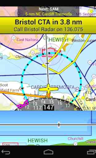
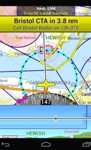
- Intelligent warnings for approaching airspace, NOTAM, obstacles, terrain and other hazards
- Virtual Radar shows a side-on projection of all approaching features and how your trajectory relates to them
- Vector map automatically follows the aircraft in north up, track up or course up orientation
- Clear and concise instruments show you flight statistics and help keep you on track
- An HSI/ILS instrument helps you keep to your planned route and line up early for approach
- Live Pilot Log shows progress through your route, ETAs, ATAs and useful frequencies based on your current position
- TerrainSafe dynamically colours mountainous terrain around you to quickly identify safer areas
- Direct To allows easy re-routing in a hurry by picking from a selection of nearby airfields
- Approach Information shows runway diagrams, TAF, METAR, NOTAM and other airfield details useful for making an approach
- Live updates of TAF and METAR while in flight, with associated alerts*
- Extended runway centrelines appear automatically on the map as you near your destination airfield
- Permanent display of position relative to nearest well-known waypoint, for position reporting
- Easy changing of the planned route while in flight by touching and dragging
* Internet connection required for live weather update while in flight
Category : Maps & Navigation
Reviews (30)
An excellent air navigation software, However the interface with SkyEcho is having numerous connection dropouts and re-pairing them is problematic.
Invaluable to G.A. pilots. The only app I'm very happy to pay for. Lots of useful tools and information.
Fantastic. Biggest advance in navigation since GPS itself was brought to the masses.
easy to use, very many cool features
For the people moaning that you have to pay the developers money, it costs less than an hours flying per year. Secondly, if you are not a frequent user, the developers have extended my subscription past the annual renewal, which is cheaper than the initial purchase anyway. In short, Sky Demon is worth every penny of the purchase price, and the option is yours to go elsewhere if you can't afford it!
A great navigation application. For me as a VFR pilot of a light aircraft the aky demon is the perfect tool to plan my flights, get all relevant data and execute ir safely. The user interface is very intuitive, works on desktop, Ipad and mobile phone, always improves and up to date. Highly recommended
Incredible piece of software ... a must for all pilots
Probably the most amazing app I have ever used. The reduction in pilot workload is fantastic allowing much more brain power to be available for flying the aircraft! It makes every flight that much more enjoyable. Thoroughly recommended.
Great great app! Easy to use and very way to understand/learn how to use. You can do whatever you need on laptop or larger tablet, and when you fly all is available on mobile or tablet! Weather/wind updates by itself using network data, restricted zones, etc... It's a must!
Has everything a pilot needs. Very clear. Very easy to use. There is so much in this app it would be hard to list it all. Once you've used it you won't want anything else. Nothing comes close. It even connects with PilotAware to display traffic.
I have a Samsung Galaxy Tab 2 which i use for flying but the latest update is not optimised for my tablet. I no longer have visibility of TAFs and METARs, can you please fix this bug as this is vital information for pilots. Please respond as I need to know if I should renew at the end of this month. 4 stars until this issue is fixed. Great quick response, issue resolved 5 stars
The best European VFR navigation app so far. The most important thing it does is keeping aeronautical information up to date (airspace, navaids, frequencies etc). I think it's more detailed and thorough compared to Garmin pilot and foreflight.
Good option for android. Does not have all the bells and whistles of foreflight but has everything you need. Developed in the UK so some features don't work in the USA.
I have been using this for about 9 months and have to say that it has become one of the most important aides in the cockpit. route planning is so easy and everything you need during the flight is readily to hand. A five star product. *****
A first class navigation app, I would literally be lost without it. Easy to use and extremely good customer service from the SD support team. I have no hesitation in recommending.
Great App with great features makes VFR flying so much easier, perfect layout of the air spaces love the weather features with wind feathers showing the current wind direction, all the current TAF and METR'S, up to date NOTAMS, accurate calculations of the time estimate and fuel usage between waypoints, great app I just wish it had approach plates just to do prepare for your arrival briefing.
Not bad but does not work as well as the iPad or iPhone app. The user experience is similar but just isn't quite as good. With a bit of refinement it could be perfect!
One of the best apps for pilots! For the smartphones please put the feature: to show the ETA of all the next waypoints (not only of the first next waypoint). Besides that, the app is perfect
Best aviation planning and navigation tool!
What an amazing app to use for Flight planning and navigation.Would most definitely recommend it!
Excellent app, always keeps me safe and legal. I've been using it for 3 years and it's always being improved. The map updates are regular and quick to install.
Unable to log in due to change of email address. I need to submit the old email address before I can reset and continue. Unfortunately, I can not remember my old email address and subsequently, I'm unable to use the app. I have tried uninstalling and reinstalling, but, the app will not let me proceed.
Essential equipment for flying! Reliable and accurate. Now if you could overlay ADS B for traffic information...that would be the icing on the cake!
Simple to use and very accurate.
Excellent app, really useful and helps increase situational awareness. Also very useful in flight planning too. Definitely worth the money.
Seems like a great app, but the trail by 30 days is no good. Trail should rather be limited to x Flight hours. Or number of days with actual flights.
This app is well arranged, useful and also simply fun to use. I love the lateral profile view of my flight plan with the airspace and weather shown.
Have seen this on a friend's iPad and was impressed. Unfortunately not able to get GPS on an Google pixel C. Any help please. Really keen to have this software. Will give 5 star once it's working.
Really good stuff in the settings , recommend going through if new user . Really happy with it so far , provides all the information you could possibly need for VFR . Impressive !
I'm a student pilot doing solo nav flights. I don't use this as my primary mode of navigation (yet) but I use it for route planning and to occasionally glance at it to verify I'm going the right way! Worth the money, and I can imagine it's invaluable once I have passed my PPL.