


Snap2Map
Ready to create a Map Tour directly from the photos on your device? You got it!
Snap2Map is a native android application built by the Esri Labs for ArcGIS Organizational users to upload photos directly from their phone or tablet to create an beautiful interactive Map Tour and share it.
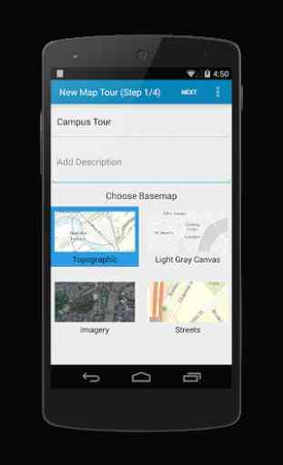
Snap2Map uses geo-tag information from the device photos if available and allow you to add/modify location information for the photos selected. You can also add captions and descriptions to each photo and upload to create a fully interactive Map Tour web application with just a few simple steps. The app and photos uploaded are hosted in your ArcGIS Organization.
You must be part of ArcGIS Organization and login as "Publisher" or "Administrator" role to create new Map Tours or use the free Developer Account. This app itself will not consume credits but you might be charged credits for storage of photos.
About Esri Labs :
Snap2Map is an app created by Esri Labs. Esri Labs apps are developed by esri employees and are inspired by our direct interactions with you -
- our customers. Esri Labs apps are free to use but are not official Esri products, so they are not holistically tested, documented or supported by Esri technical support.
Snap2Map is a native android application built by the Esri Labs for ArcGIS Organizational users to upload photos directly from their phone or tablet to create an beautiful interactive Map Tour and share it.
Snap2Map uses geo-tag information from the device photos if available and allow you to add/modify location information for the photos selected. You can also add captions and descriptions to each photo and upload to create a fully interactive Map Tour web application with just a few simple steps. The app and photos uploaded are hosted in your ArcGIS Organization.
You must be part of ArcGIS Organization and login as "Publisher" or "Administrator" role to create new Map Tours or use the free Developer Account. This app itself will not consume credits but you might be charged credits for storage of photos.
About Esri Labs :
Snap2Map is an app created by Esri Labs. Esri Labs apps are developed by esri employees and are inspired by our direct interactions with you -
- our customers. Esri Labs apps are free to use but are not official Esri products, so they are not holistically tested, documented or supported by Esri technical support.
Category : Productivity
Related searches
Reviews (2)
Der. S.
Jul 27, 2016
You are unable to snap photos into map directly from the app. First take photos, then open the app and choose photos later. This decreases productivity.
I know.is a Q animal far away