Spain Topo Maps
Easy to use Outdoor/Offline GPS navigation app with access to the best topographic maps and aerial images for Spain.
Including Balearic Islands and Canary Islands
++ For offline use PRO features needed ! ++
Turn your Andoid Phone/Tablet into an outdoor GPS for trips into the backcountry WITHOUT CELL COVERAGE. This app gives you similar mapping options as you might know from Garmin or Magellan GPS handhelds.
Included FREE map layers:
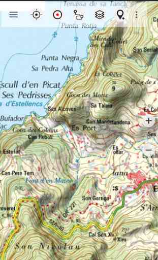
• Spain Topo Map: Mapa Topográfico Nacional 1:50.000 & 1:25.000 (IGN MTN25 & MTN50)
• IGN Base Map: Base Topográfica Nacional 1:25.000 (BTN25 & BCN25)
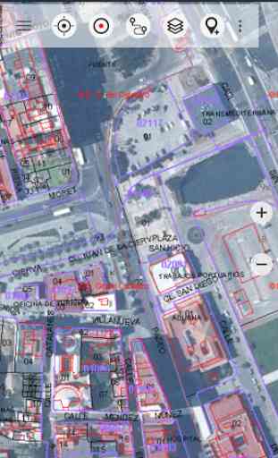
• Spain Imagery: High resolution aerial imagery. Plan Nacional de Ortofotografía Aérea (PNOA)
• Catalonia Topo Maps: High resolution topographic maps for Catalonia
• Land Register Map: Cartografía Catastral
• OpenStreetMaps : These crowdsourced maps are a very useful addition to other map layers. Contains many unique features.
• OpenCycleMaps: These maps are ideal to plan bicycle trips
• ESRI Topographic
• ESRI Aerial Images
• ESRI Street Map
• Google Road Map (online access only)
• Google Satellite Images (online access only)
• Google Terrain Map (online access only)
• Bing Road Map (online access only)
• Bing Satellite Images (online access only)
• Earth At Night
• Hillshading overlay
Main features for outdoor-navigation:
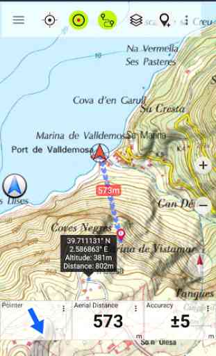
• Create and edit Waypoints
• GoTo-Waypoint-Navigation
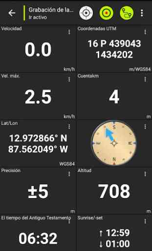
• Track Recording (with speed, elevation and accuracy profile)
• Tripmaster with fields for odometer, average speed, bearing, elevation, etc.
• GPX/KML/KMZ Export
• Search (placenames, POIs, streets)
• Customizable datafields in Map View and Tripmaster (e.g. Speed, Distance, Compass, ...)
• Share Waypoints, Tracks or Routes (via eMail, Whatsapp, Dropbox, Facebook, ..)
• Display coordinates in Lat/Lon, UTM or MGRS/USNG (Military Grid/ US National Grid)
• Record & share tracks with statistics & elevation profile
• Rotate map (Track Up & North Up)
• Get Elevation by long click on map
• Track Replay
• and many more ...
Available Pro features: (Pro features available via In App Purchase)
• Offline Use
- no cell coverage needed
• Easy+Fast Bulk-download of map tiles for OFFLINE USAGE (not for Google and Bing maps)
• Create and edit Routes
• Route-Navigation (Point-to-Point Navigation)
• GPX/KML/KMZ Import
• unlimited Waypoints & Tracks
• Add other Map Tile-Server
• No Ads
Offline Use:All viewed map tiles are kept in cache. To cache large areas you need to purchase Pro features.
Use this navigation app for outdoor activities like hiking, biking, camping, climbing, riding, skiing, canoeing, hunting, offroad 4WD tours or search&rescue (SAR).
Add custom waypoints in longitude/latitude, UTM or MGRS/USNG format with WGS84 datum.
Import/Export/Share GPS-Waypoints/Tracks/Routes in GPX or Google Earth KML/KMZ format.
Preload FREE map data for areas without cell service (Pro feature !).
Comments and feature requests to [email protected]
Have a look at our other outdoor navigation apps: https://play.google.com/store/search?q=atlogis
+++ We DO NOT track any user activities or collect any user data ! +++
Category : Maps & Navigation
Reviews (24)
All these topographic maps are pretty good, thanks to a scale that is not too large. That being said, all the territories and islands (eg. Ibiza, Mallorca, Tenerife, etc.) that belong to and form part of a country should come included in that country's package, instead of charging for every rock in the sea separately.
The app is easy to use but has lots of options to make it a powerful tool. Needed something with detailed maps for mountain bike route planning. This app displays various topographic maps at different zoom levels giving you unrivalled level of detail in a super clean and easy interface.
Detailed mapping of Spain; as good as it gets for Spain Runs well on my Samsung Galaxy Note 9. As good as the printed maps which record a similar scale, though no match for good old Ordnance Survey. I've used this for off road activities in Spain's extensive, but usually poorly signed, rights of way on vehicles, bikes, kayaking and hiking in remoter areas. I haven't used it for built up areas. Recommended for the more intrepid explorer of the fantastic country that Spain has to offer
Only good for maps library. Instructions and tutorial absolutely insufficiente. Ratio quality /price close to zero
Brilliant. Easy to use and the choice of maps is perfect.
Very useful and easy to read cartography. Ideal for planning my campervan trips to Spain. Shame it isn't possible to upload on to my pc for a bigger screen view.
Fantastic app that is much better than the paper maps that are available.
very detailed map, useful and practical
easy to use and just what you want
Easy to use and detailed.
great, really big time cartography for real. simply a must for a real traveller :-)
Good, detailed map, but a bit out of date here and there.
Fully featured at a good price. Works offline too.
Waypoint coordinates format selection is very useful
Unbelievable map. Love it.
Brilliant need one like this year's ago
Excelent maps works everywhere😷
Love this app for walking....very detailed
Outdated map
Could be a lot better, isoltaed from Europe and Mediterranean northern Africa. Not useful for broad navigation, but is good for local foot-journeys.
Only on-line map, you see nothing without internet... Try MAPS.CZ and download SPAIN in it...
All I see in the map area is a black screen. I have the icons across the top, but no map, just a black screen. And that was after updating. Before that it was just some weird white and tan checkered screen. Is it me? Am I not doing something right?
Not initiative , offline features bad, not worth the cost
This is a great tool. The free version gives you access to pretty detailed aerial view, not satellite so the resolution is pretty sharp. Topo maps are very detail rich; the terrain features don't always line up with what is shown on Google or Here maps. I wish there was access to the legends and margin data for these maps; don't know what all of these symbols represent. I'll probably spring for the paid version so I'll be able to draw and save routes and waypoints, and to use all their products.