SpyMeSat
Category : Tools
Reviews (30)
Not live the images are old And from Google maps
Unfortunately, access to any high res satellites is costly. The free satellites are lower res than Google Earth, hardly usable at all. Not a very large selection of satellites either.
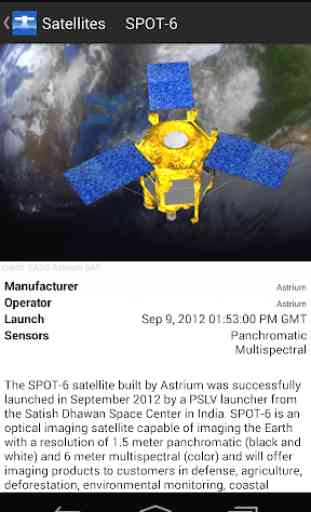
I like this app. Its pretty interesting to see the information surrounding satellites in orbit as well as satellite imagery.
Free to download, but be ready to pay upwards of $100/month for the "privilege" to use the satellites. Thereby, making them guilty of false advertising.
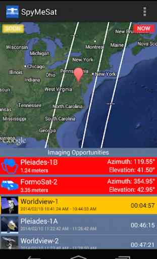
Interesting tool that allows you to see what satellites are overhead. Notifications are awesome
Joke, prices are literally out of this world which are free or next to nothing on other very similar apps like ISS detector, sky maps, and satellite safari.
Doesn't even start, tried on two totally different devices. Waste of time.
At least add Landsat and Sentinel as well in the mix so that we can alert ourselves of next flyby. You have all paid ones.
Useless, only shows me googles old map from 2018. Cannot view any new maps or archives
The interface seems a little clumsy, but works well enough.
App always crashes when I want to view my Tasked images.
Only mobile app that allows corporate satellite tasking
Force to close the app!
This is the best SATELLITE APP EVER
Google maps far better who's going to pay 19 bucks to 500 bucks for some image that Google produces.
A very useful tool for professionals
another useless google satellite imagery app. that is years ouy of date for Tumbarumba NSW Australia
Love it best app for looking for etrustins
Id give -100 stars if i could. I just google earthed the same location im trying to view anf these jacka**es have the exact same image that i know for certain is a year old at least and claim its live view... Liars
its 2 - 3 years behind
Doesn't tell you that you have to buy the images!!!
Actually I thought it was something else sorry it is very COOL.
It's so amazing this apps
Same outdated (4yrs old) as u get on google
Nothing in this app is free.
Like this app
Shows the satellites that may be observing you in sometimes startling detail. Easy to use.
I can't even register it keeps telling me my passwords don't match. A waste of time
App is crashing all the time.
I can't figure out how to use it to see a current image and what are the prices actually for $325 gives me what. And why do you have options to put in dates on didn't give me a current image of it the image I see is old but don't show the date. Need a tutorial.