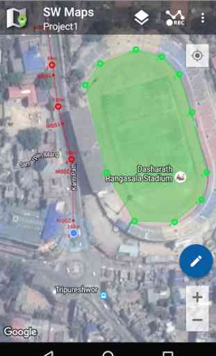
SW Maps - Mobile GIS
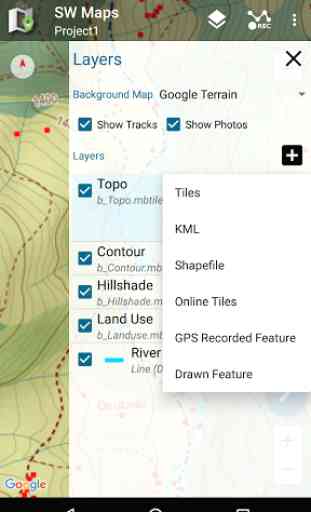
Features-Online Base maps: Google Maps or Open Street Map
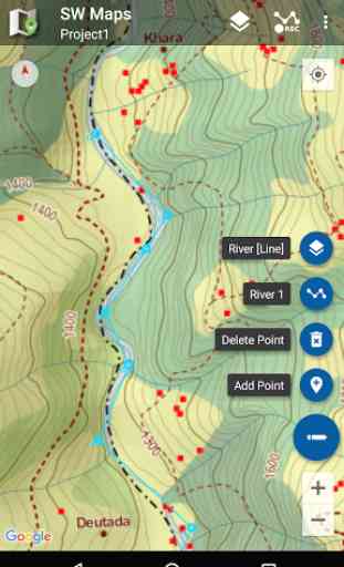
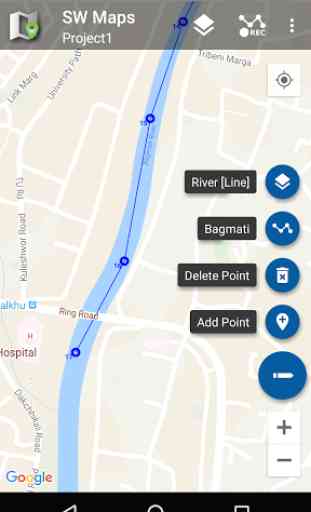
-Support for multiple mbtiles and KML overlays
-Shapefile layers, with attribute categorized styling
-Define multiple number of feature layers, each with a set of custom attributes Feature Types: Point, Line, Polygon Attribute Types:Text, Numeric, Drop down Options or Photos Save as Template for re-use or sharing
-Record GPS tracks, with distance measurement
-Draw on features on map and export as kmz or shapefiles.
-Label features based on attribute values.
-Import feature layers from templates or existing projects.
-Share or export collected data as KMZ (with embedded photographs) or Shapefile
-Share templates or projects with other users
-Connect to external GPS receivers through Bluetooth
To load MBTiles, KML and shapefiles from external SD card, create the following folders in the SD card root and copy files to the relevant folders.SW_Maps/Maps/mbtilesSW_Maps/Maps/kmlSW_Maps/Maps/shapefiles
This product is made in Nepal and is FREE (no Ads). If you find this useful, please let your friends know that you have used a product from Nepal. Spare sometime to visit this wonderful country and know the Nepali people.
Category : Productivity
Reviews (19)
It is the best app I have evere seen but after that I updated the SW maps about a week ago, I can't export my project as shape file anymore and when I try to export as shape file, the app will close and kick me out ☹
The SWMaps download file is version 1.3 dated 2016 and does not reflect all the options in the current SWMaps version. Please provide an updated manual!
In general is the best free GIS collector out there. I recently found a serious bug where shapes having numeric attributes loose all decimals when they are displayed. That kills all accuracy in the data and the symbology. Please solve this serious bug. I sent an email explaining the issue.
Everything was fine before upgrading to the newer version of android (upgraded to android 11). My layers suddenly disappear when I tried to zoom in/out or when I scrolled the screen and it needed more time to appear again. This app is really important for me, I really appreciate if you fix this issue.
This app is really amazing&has a lot of potential for field work and surveying projects. The only thing that I am wondering (not sure if this really isnt possible yet, or if I am missing something): when you add layer attributes, I cannot modify them anymore afterwards. Also I cannot change their order (would be nice to have a drag and drop). That means if I add a layer attribute&made a mistake, I would have to delete the whole thing and make it new. Any chance you can change&improve that?thx
Currently the app is in very bad condition, it keeps stop and closed at same time when I tried to add my layers.
Its a great open-source mapping utility, but i was unable to export my data, all the CSV and XLS format were corrupted or either too long to export like more than days once finished exporting the data were unable to be opened. Im looking forward to use this as a daily driver for a mapping database. **update : I am unable to export, share option shows to process/progress
Awesome Lately, I see NTRIP is available on YouTube videos. Buy my installation des not show NTRIP in the drawer menu :(
I really liked this app. Have been using for survey purpose. But whenever the mobile display turns off after being inactive for ( depending on user like 30 seconds ) it's connection to GPS will stop . And continue after only I unlock my cell. Between the two events it just shows a straight line. Please tell me how to sort out this problem.
Started using it for a project and was really happy with how easy it was to use - until I tried to draw a feature within the area of a previously drawn feature. it just won't do it. I was trying to draw areas, then subdivisions of those areas, then specific points within the areas, but I don't seem to be able to do it.
Seems to work well. Have a question though: I went out and recorded a bunch of points but when I import the kmz to Google Earth it doesn't display the point numbers, which I need it to. It just says "Layer 1" next to each point. Only if I click on the point does it show the point ID. Any help?
Awesome app! The fact you can see vertical elevations is great when using an RTK receiver. On addition that would make it more useful is the ability to add Rod/Pole height to correct elevations for the vertical offset. Thanks for making this app!
Seems to be the only app of this kind that is actually free. The 5 or 6 others I tried were free until you need to actually do something useful with the data (like export a shapefile), then they hold your data hostage for a fee.
Hi, I'm a user of U-Blox ZED-F9P RTK receiver and trying using SW Maps as for as NTRIP client. There is no problem when I connect the receiver via bluetooth. Also it can be connected with our national NTRIP caster. But when I checked the rover position through the NTRIP caster portal (website), the latitude position of rover was wrong, while the longitude was correct. The latitude position should be in S (south), but detected as N (North). So I can't reach fix solution for that. Please help
This is a absolute free app. I is user friendly with simple functions and effective layout. I like the data structuring, import/export and file format options. Thank you for this app.
Very easy to use for field data collection. Good export options. Reliable and intuitive. 5 stars for the software it's free but better than many paid for apps.
Its a truly useful app. If we could add DATE and TIME in attribute types of layers and record the system date and time, it would be more useful for my public transport system survey.
The app is great. In future versions, it is possible add a simbology that lets users view strike and dip (or dip and dip direction) of planar structures? Similar to Field Move.
This is pretty nice, but 2 things that seem like they might keep me from using it for my little task (amateurish mapping of plants and other features in a nature reserve are: 1) no apparent capacity to add as many photos as you want (could of course add features photo1 photo2 etc, but mapit gives you a list with a button to see it or not). Comments on photos would make it even better. 2) a lot of stuff at the top of a feature record that I usually don't want to see (visibility toggle?)