Sweden Topo Maps
Easy to use Outdoor/Offline GPS navigation app with access to the best topographic maps and satellite images for Sweden.
++ For offline use PRO features needed ! ++
Turn your Andoid Phone/Tablet into an outdoor GPS for trips into the backcountry WITHOUT CELL COVERAGE. This app gives you similar mapping options as you might know from Garmin or Magellan GPS handhelds.
Included FREE map layers:
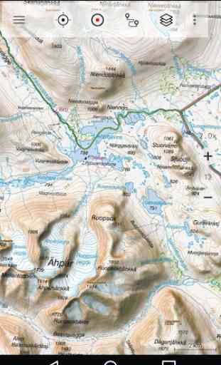
• Topographic Map 1:50.000 for Scandinavia ( Denmark, Norway, Sweden und Finland) with hillshading. Lantmateriet Terrängkartan + Fjällkartan
• Topowebb Lantmateriet Topographic Map for Sweden
• OpenStreetMaps : These crowdsourced maps are a very useful addition to other map layers. Contains many unique features.
• OpenCycleMaps: These maps are ideal to plan bicycle trips (PRO Users only !)
• ESRI Topographic
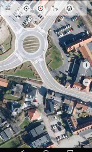
• ESRI Aerial Images
• ESRI Street Map
• Google Road Map (online access only)
• Google Satellite Images (online access only)
• Google Terrain Map (online access only)
• Bing Road Map (online access only)
• Bing Satellite Images (online access only)
• Earth At Night
• Hillshading overlay
Main features for outdoor-navigation:
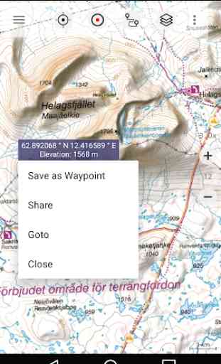
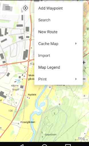
• Create and edit Waypoints
• GoTo-Waypoint-Navigation
• Track Recording (with speed, elevation and accuracy profile)
• Tripmaster with fields for odometer, average speed, bearing, elevation, etc.
• GPX/KML/KMZ Export
• Search (placenames, POIs, streets)
• Customizable datafields in Map View and Tripmaster (e.g. Speed, Distance, Compass, ...)
• Share Waypoints, Tracks or Routes (via eMail, Whatsapp, Dropbox, Facebook, ..)
• Display coordinates in Lat/Lon, UTM or MGRS/USNG (Military Grid/ US National Grid)
• Record & share tracks with statistics & elevation profile
• Rotate map (Track Up & North Up)
• Get Elevation and Distance by long click on map
• Track Replay
• Add custom map tile servers
• and many more ...
Available Pro features: (Pro features available via In App Purchase)
• Offline Use - no cell coverage needed. No Roaming fees !
• Easy+Fast Bulk-download of map tiles for OFFLINE USAGE (not for Google and Bing maps)
• Create and edit Routes
• Route-Navigation (Point-to-Point Navigation)
• GPX/KML/KMZ Import/Export
• unlimited Waypoints & Tracks
• Add other Map Tile-Server
• No Ads
Offline Use:
All viewed map tiles are kept in cache. To cache large areas you need to purchase Pro features.
Use this navigation app for outdoor activities like hiking, biking, camping, climbing, riding, skiing, canoeing, hunting, offroad 4WD tours or search&rescue (SAR).
Add custom waypoints in longitude/latitude, UTM or MGRS/USNG format with WGS84 datum.
Import/Export/Share GPS-Waypoints/Tracks/Routes in GPX or Google Earth KML/KMZ format.
Preload FREE map data for areas without cell service (Pro feature !).
Comments and feature requests to [email protected]
Have a look at our other outdoor navigation apps: https://play.google.com/store/search?q=atlogis
+++ We DO NOT track any user activities or collect any user data ! +++
Category : Maps & Navigation
Reviews (14)
The map of Sweden just doesn't download for offline use. I've tried many tine with and without Wi-Fi and it just doesn't work. Other countries weren't a problem by the one I actually need doesn't work. I've purchase the extended version and I'm quite disappointed, as I really don't know what the problem is.
This app has beautiful hiking maps of Sweden, good OSM maps of the rest of europe too, and even dedicated water and cycling maps. Works well, not too complicated. Satisfied user of the pro version for years already.
The topo map is very fuzzy when zoomed in. Free alternatives are not. Crashes when many POIs are loaded. Loses POIs constantly. Disappointed with this app.
Very good and usefull. Only thing that annoy me is that the map rotates too easy, whenever I zoom in or out.
Stable and good. I use it when walkingand running in new areas and cities
Great app, I use it to navigate on gravel roads.
Does the job. Nice to have terrain maps where I go in Sweden.
used to be my go to, but feels dated now...
Great app! Thanks!
BOSCH N GONj 🇸🇪🇸🇪🌏🗺️All time WORLD Working play Bank WORLD FRIENDS com Bank 🗺️🌎🌍🇸🇪🇸🇪 (1) UNITED STATES SETTINGS STREET View OF COM (2) UNITED KINGDOM SETTINGS STREET View OF COM (3) STREET SETTINGS VIEWS OF COM
It's a good app but afaik it lacks the ability to add photos to saved way points.
Map scale is wrong by a factor of approx 2x
Most pro features are still not working after I payed for it
Really nice, simple to use map software for Nordics. I especially appreciate how it shows Finland, Norway and Sweden on the same map layer. Negatives: no ability to lock north, makes zooming around a bit annoying. Some map data from Finnish side is slightly outdated, and some pieces from Kilpisjärvi region at least are missing. Bug: If adding a waypoint via "Add Waypoint ->Edit coordinates", the waypoint editor is wonky. It autocapitalizes evert word, doesn't let you choose an icon or folder.