Tactical NAV
This app is an indispensable tool. Map & plot navigational waypoints, share location and waypoint information with other Tactical NAV users by email using encrypted security, and even take photographs stamped with GPS coordinates. These are just some of the tools the U.S. Military and NATO Armed Forces use to conduct combat operations on a daily basis
- and now, these tools are available to YOU in Tactical NAV.
★★★★
★ VOTED APP OF THE MONTH BY APPDICTIONS.COM ★★★★★
❋ COMBAT TESTED. MILITARY GRADE. GOOGLE PLAY APPROVED. ❋
❋❋ AS SEEN ON THE BBC, CNN, CBSNEWS, FOXNEWS, MSNBC, AND THE NY TIMES ❋❋
★★★★★A MUST FOR THOSE WHO HAVE AN IPHONE IN A-STAN"The GPS is right on the money (using a DAGR to compare with). The best and most useful feature is the capability to take pics with the coordinates stamped in ... a must have app for all deployed military members who actually leave the wire."
★★★★★AWESOME APP"Was just in Korea and the app worked perfect. The new nav to a grid is great also."
- Trunco Inc
You may be a soldier on active duty, out there putting your life on the line for your country, or maybe you brave the wilds as an adventurer, hunter, hiker or camper. In any of these situations, it’s important to have the right tools along to keep you on target and safe.
Thanks to Tactical NAV, you can have everything you need for navigating anywhere, all in one handy application for your Android device.
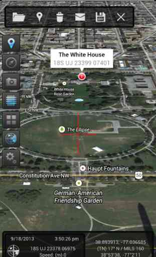
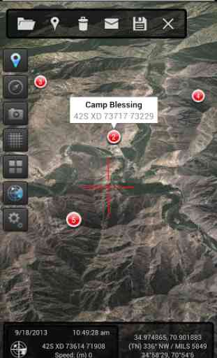
This app puts the military grid reference system (MGRS) and field navigation in the palm of your hand. Yes, you can now access the same resources used by the U.S. Military and NATO Armed Forces worldwide.
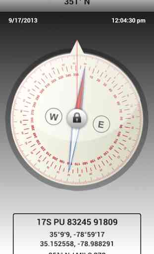
Soldiers will appreciate how Tactical NAV can help in the field. Map, plot and photograph navigational points, find your way back to an observation post, employ the night mode function for easier viewing in the dark, switch between different types of data and take advantage of Camera mode, with data displayed in real-time and photo stamping ability.
Everything you need is here and has been extensively tested for accuracy in the remote mountains of Afghanistan during combat operations. Tactical NAV is on par with many of the GPS devices used by U.S. Soldiers today.
Although Tactical NAV is military grade, it works great for civilians, too. Are you an adventure traveler? Like to hike, camp or hunt? Track your route or save waypoints so you can retrace your steps, easily find your way back to your vehicle or campsite and never worry about getting lost again.
Look at the features you get in Tactical NAV:
* Cross-platform support between iOS and Android OS
* Military quality GPS tactical navigation system
* WGS 84 standard
* Tested in combat to ensure utmost accuracy and reliability
* 1:50,000 map scale overlay (1km by 1km gridsquares)
* Waypoint plotting functionality
* Fully editable waypoints
* Location and waypoint sharing via email with other users
* Compass lock function
* Fast user switching between degrees, Mils, elevation, LAT/LONG, and MGRS data
* Camera mode with heads-up data displayed in real-time with photo stamping ability
* One-button night mode function
* "Go to Grid" option
* Multi-tasking support
* Free updates as they become available
* And so much more!!!
Download Tactical NAV now and put a portable, military quality tactical navigation system to work for you.
IMPORTANT NOTES:Tactical NAV should never be used in place of authorized Department of Defense equipment and systems. A data network is required for map downloading. Please enable location services. Tactical NAV is not endorsed by the U.S. Army, the U.S. Military, or the Department of Defense.
Category : Maps & Navigation
Reviews (26)
Paid for it... Don't work at all with Android 🙃
Previously I used this app all the time and would have rated 3.5-4 stars. Got a new phone and nothing even loads. No updates in months, the photo with bearing feature still crashed (until i upgraded, now it all does). It's like the designer stopped caring. Kinda sad.
So I paid for this app not sure if it still cost money. But it doesn't work on s8 and it did everything I needed.. would gladly pay more for a quality product and support that followed a good app to the end... These people don't care about their sales on top devices
However, it is now nearly three years since the last update. There are bugs big and little needing addressed, and missing features that would make this app invaluable to all users. If these things continue to remain ignored, it wouldn't be long before another developer came up with something that would completely render this one obsolete
NO moving map. Yes, your position marker moves, but the map must be manually moved with it - annoying. NO configuration settings. NO offline map storage. NO compass calibration. NO feeling of credibility as a Mil-spec app 'for the troops' due to update lag. It does run without errors on an LG G3.
Severely lacking in the interoperability with its apple counterpart. Also,it lacks many of the features seen on Apple. I only purchased it to be able to recieve map overlays for the TOC , which it cannot do. Purchased over a year ago and it's still lacking the same functionality as iOS. Good concept, great on Apple, disappointing on Droid.
APP CRASHES AFTER INITIAL LOAD SCREEN ON S7 EDGE. WHAT IS THE POINT OF AN APP THAT DOESN'T WORK.
Need to upgrade features still shows empty lots or property (buildings) need update satellite picture , now this is 2016 and there's no response from you guys and still no updates
As a previous person stated it crashes whenever I try to take a picture. I also cannot load a way point list sent to me from an Iphone. I am using the Galaxy Note 2.
Can't get camera to play nice with tax nav on my note 4
Won't even start. Installed on Note 5 and app crashes every time I try to start.
the map tiles would not download for my area in australia and was very buggy. would be great if this could be fixed as the concept is awesome.
It won't let me measure distance across the ground (feet, yards, meters, miles, nautical miles, km) and won't give me a heading between two points (magnetic, true, grid). Pretty much worthless without those two things in my opinion.
Used to be a great app, now on my new Galaxy S8 it will not load, please fix as I have paid for this app and it can't open.
After androids latest lollipop update the app no longer functions as designed at all.
Support for Galaxy S8+, home screen opens and then instantly crashes. Great app! When I had the S7.
This was a really great project, but really could use someone picking it up and running with it again. I hope the developers get back to it
Downloaded the app. Would never open or let me use it. Didn't work, waste of time
App needs to be upgraded to match the apple version. And to run on tablets. The limited android version runs on my old phone but not my new tablet
Thank you for a wonderful and useful app. I have had great success marking out routings for hikes and way points etc. PLEASE add a tool to calculate distance from way point to way point as well as cumulative total distance and adding the first 2 reference numbers onto the yellow grid lines and then I will absolutely upgrade to 5 stars. Thank you very much for a great tool.
Basically is has a great setup. Could be better. More tactical overlay options, routes, offline map capability. Keep building on this app.
Need an offline mode. I'm in the military and use this app a lots when training. But if I go oversea without data, this app is useless. Need a way to save the map for offline use
Great app but I wish there was a way that I could import/export waypoints and possibly even create and save routes. You can input a waypoint but you cant navigate to a saved waypoint. All it shows is a close up of your point. I would like to see where I am and where the point i am going to is. If there already is a function it is not showing for Androids. I would like to see a Latitude and Longitude input so I can work on the water with it. Looking forward to the upgrades.
I'm not able to input proper MGRS grid, there are no tactical graphics to use, not able to measure distances between points.
This app can help me to find a way out when someone or me get lost. I am getting used to it.
Best app for Civilian use. I even use it when in the field and During an FtX or WfX. Just a Triciary nav system for ops.