Te Araroa Hiker
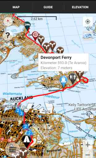
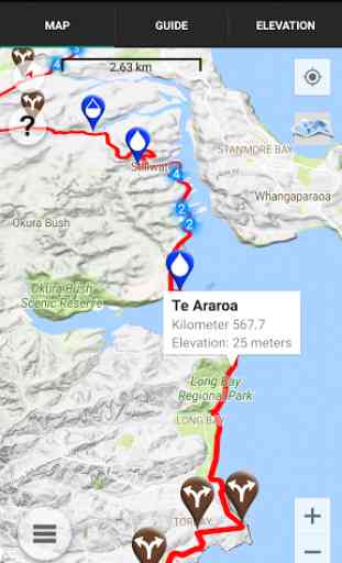
NO PHONE OR INTERNET SERVICE IS REQUIRED to use Te Araroa Hiker after the initial setup. Te Araroa Hiker uses a combination of your smartphone's GPS, downloaded LINZ topo maps, and the Google Maps interface to accurately locate your position on the Te Araroa. Your device's GPS pinpoints your location on the downloaded topo maps.
The free demo covers a 60 kilometre portion of the Te Araroa on the North Island from Silverdale through Auckland. The demo is fully functional with all features of the paid version. In-app purchases include guides for the North Island from Cape Reinga to Hamilton (800 km), North Island from Hamilton to Wellington (900 km), South Island from Ship Cove to Lake Tekapo (690 km), and South Island from Lake Tekapo to Bluff (610 km).
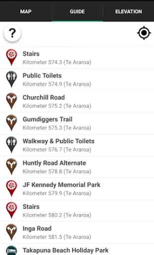
A bright red line indicates the location of the main trail on the map. Waypoints of interest to the hiker are plotted on the map, listed in a guide, and plotted on an elevation profile.
Send your current location to friends and family via text message or e-mail.
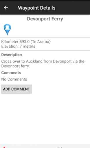
Each waypoint includes a detail page, providing further details about that particular waypoint. Details include the waypoint's mileage point and elevation, distance to the next water source and tent site, a Comments section where you may post comments and read other users' comments, and other details that will help you during your hike, and help you plan your hike.
The types of waypoints include:
-->Water sources-->Tenting sites/camping sites-->Trail junctions-->Picnic areas, campgrounds, ranger stations-->Roads, stiles, gates-->Natural landmarks (e.g. mountain peaks)-->Toilets-->Views-->Resupply and town information, such as supermarkets and lodging
Category : Travel & Local
Reviews (23)
Used it for my entire TA found it extremely useful it was my only map navigation resource read the trail notes night before section used it mainly as how far to hut camp road etc and if I got lost which happened often app worked in battery save and aeroplane mode all transmitters off battery lasted several days
Loved this app, but latest update my trails already purchased aren't there. Only has options to buy them again! Can't log in and reset password function doesn't email me. Help!
Atlas guides... Please fix this app! It's a great app but crashes every time I try to add a waypoint.
App keeps crashing of not in flight mode even with 4G+ connection. For 40$ i was hoping for something more stable...
Brilliant app, has been so handy the whole way along the TA. Would highly recommend it while out on the trail.👍
great app. used it for the Larapinta no dramas. didnt even look at my back up paper maps one.
Nobo directions are in reverse ie go left means go right. For one section map failed to load which was problematic.
Navigation worries become a thing of the past with Guthook!
Buggy but the best guide available for the Te Araroa
Used the app yesterday on a practice hike for my upcoming November Te Araroa odyssey. Meets all of my expectations. Thank you. 😎
Good app. Not as user friendly on android though.
Good app for navigating a trail
takes time to get used to, the more you use it the better it gets.
Te Araroa Maps are bliss, such a good concept 🌞
Bit of a junk app. Atleaat around here.
Another good app
10 out of 10.
Good to have
Love it
I used Guthook apps on the Pacific Crest Trail and it is literally a life saver. Now using in New Zealand. It can save weeks of planning, prevent you getting lost, put your mind at ease when you are isolated or running low on food or water, and makes it very simple to plan where to camp.
I used this app for the Bibbulmun. It is definitely usefull and is cheaper than buying paper maps. The Bibbulmun maps don't seem to be used much I've only seen comments from one other person. It could do with some proofreading and added detail. There are a few mistakes. Waypoints for alternate roots have no explanation. There are also waypoints for plants and animals someone saw (The strangest one I saw was called "keeping the flies off" and showed a person with a hay over their face). Overall the maps for the Bibbulmun seem sloppy and unprofessional but are functional.
Excellent app, using it on the TA, it's been a necessity with the occasional poorly marked sections of trail.
I found this a useful backup to The Trail App for Te Araroa. The photo interface is good and the distances reasonably accurate. The distance ahead and behind feature is great as is the ability to specify travel direction. I would give a higher rating but changing maps or between maps and photo overlay is surprisingly clunky for such a globally useful app.