The Colorado Trail Hiker
NO CELL OR INTERNET CONNECTION REQUIRED for the app to work on-trail. After initial setup, the app uses your GPS and offline maps to guide you along the trail.
The free demo is a fully functional version of the app with Segment 1 of The Colorado Trail (Miles 0 to 16.8 from the Waterton Canyon Trailhead outside Denver). In-app purchases include (1) The Colorado Trail, which includes the hiking route, the five mountain bike wilderness detours, the Collegiate West Alternative route and the Collegiate Loop (775.2 miles of trail in total) and (2) a standalone version of the Collegiate Loop route (a 161-mile loop composed of the 82.3-mile Collegiate West Alternative route and a 78-mile portion of The Colorado Trail).
The app has been built in partnership with Jerry Brown of Bear Creek Survey Service. Each waypoint in the Colorado Trail Map Book, written by Jerry Brown and offered by The Colorado Trail Foundation, is plotted and described in The Colorado Trail Hiker app. A portion all proceeds from the sale of The Colorado Trail Hiker app will go to The Colorado Trail Foundation.
The Colorado Trail Hiker uses a combination of your phone's GPS, downloaded topo maps, and the Google Maps interface to accurately locate your position on the trail. No phone service? Not a problem -
- your phone's GPS pinpoints your location on top of topo maps downloaded as part of the app.
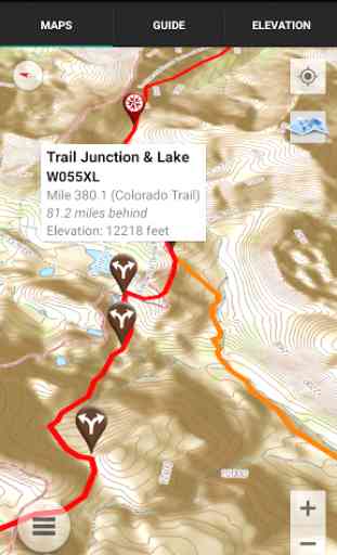
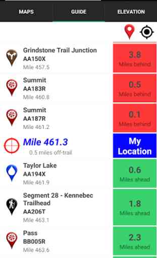
A bright red line indicates the location of The Colorado Trail on the map. Alternate routes are indicated in other colors. An elevation profile shows trail distance vs elevation and plots your current location on the trail. Each waypoint is plotted on the profile. Each waypoint is clickable, opening to the waypoint's detail page.The guidebook lists every waypoint in order by distance along the trail.
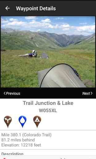
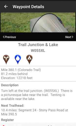
Each waypoint includes a detail page, providing further details about that particular waypoint. Details include the waypoint's mileage point and elevation, photographs of many of the waypoints, distance to the next trailhead, a Trail Register where you may post comments and read other users' comments, and other details that will help you during your hike, and help you plan your hike.
The types of waypoints include:-->Trailheads and parking areas-->Water sources-->Resupply towns/services-->Trail junctions-->Road crossings-->Powerlines, fences, gates, toilets-->Other Landmarks and points of interest
Category : Travel & Local
Reviews (28)
Awesome app! We did Segment 12 and always knew where we were and what was ahead. The water way-points and the ability to add and read user comments is a fantastic feature. I was able to plan where to get water and, unlike a paper map (always carry a map as backup people!), find out which water way-points were active, find notes on camp sites, etc. All in all, very useful and would recommend this app to any and all! Locke Nest Adventures
I thru-hiked the CT during the summer of 2019 and this app was invaluable. The mileages were sometimes off by a few points of a mile when referencing the CT Databook, but overall a great asset on trail! I really liked that I could use it in airplane mode with GPS turned on. Great app!
Great app for hiking the trail. Only suggestion for improvement is to have a separate designation for campsites like on the PCT and AT versions.
The map kept me on trail in the middle of the night while delirious. I plan on using it again this year. Great app!
Spot on in every way and I really like the ability to read and share updates for each way point. Well done!
I just finished the Collegiate Loop. The app helped point out water resources and some campsites.
Absolutely awesome program and indispensable while hiking the trail.
Gets better with time. Be sure to update the maps and routes!
excellent! dont hit the trail without it.
This has made navigating on and planning days on trail a breeze
A must have for thru hikers of the Colorado Trail. Updated water reports from other hikers are worth gold.
The app needs to list campsite
This app is a must for any hiker. Love, love love this app.
Love the app but much of the functionality fails on Collegiate West. It failed to identify that we were on that alternative and guide became elevation and useless. The map still worked. I (and others) may have missed something but a setting similar to the North/Sount option would be handy for East/West so that it knew we were on trail and listed the relevant local features and elevations.
Issue on galaxy s8, app works on first download, but after anytime reopening it just says "loading map" then the app freezes... Please fix, I leave for CT in 2 weeks. Edit: it took like 5 minutes, but the app loaded with map, all working... Would like for it to be quicker, because it did seem on the verge of crashing
Doesn't work with Galaxy Note 4 running Android 6.0.1. Opens to trail screen then immediately crashes. Edit: Great response from developer and they were able to update the app to work with my phone. Very much appreciated!
This app was great for us while horseback riding the trail. Only thing I would like to see added is livestock water. We were able to find some slightly off trail but would be nice if it was marked as well as just fresh water.
Works well though sometimes takes a bit of time to catch up. Comments from other users re water sources, etc are esp useful.
Very helpful. Colorado is going through a drought so some of the listed water sources are dry, but thankfully there are comments sections so people can warn you and tell you where else to get water. Wouldnt have made it this far without this app!
This is Definitely helping me get through the Colorado Trail without getting worried about getting lost, and allowing me to decide how much further I can go. I'm obsessive about checking it. I hope I start leaving it be for longer amounts of time.
I think this app is great! The only think I'd like to see in the future is a way to have a live radar update so we can know what the weather is like ahead.
Works poorly on Android. Takes forever to load maps and it is always trying to reload the map. Good as last resort.
Very useful App. I have a Samsung Galaxy active and it works very well with it. Love that it can tell you exactly where you are, the elevation, and how far it is to different waypoints. You can also comment and read up to date info on water flow.
This has been the best $ I have ever spent. Use the ap to check in on where I am at in relation to the CO Trail! Saved me enough times to make it worth every penny!
This app has basically no trails. I know of a bunch near me and it displays zero
Awesome the only thing you need for guidance on the Colorado trail
Great app. Works well. Used it to locate myself on the COLLEGIATE Loop this year.
The app worked out decently well for my CT NOBO thrue hike. However, I'm disappointed that it didn't list campsites. Also, sometimes there'd be a "2" on the map indicating two points of interest, yet nothing would populate. For these reasons, I gave it 3 stars. If the price of the app is reduced or campsites are added, I'd give it 5 for sure. Until then, the guidebook is cheaper and better.