The Florida Trail Guide
The Florida Trail Guide is a detailed, map-based smartphone guide for your hike on the Florida Trail. It lists important hiker waypoints on the FT such as water sources, shelters, tenting sites, road crossings, resupply locations, and may others.
NO PHONE OR INTERNET SERVICE IS REQUIRED to use The Florida Trail Guide after the initial setup. The Florida Trail Guide uses a combination of your smartphone's GPS, downloaded topo maps, and the Google Maps interface to accurately locate your position on the trail. Your phone's GPS pinpoints your location on the downloaded maps.
The free demo covers the 42.3-mile Blackwater route from the Florida-Alabama border to Harold. The demo is fully function with all features of the paid version. In-app purchases include sections of the Florida Trail.
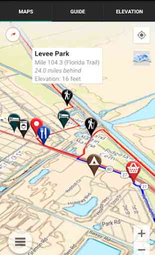
A bright red line indicates the location of the main trail on the map. Side spurs to water sources or other points of interest are indicated in blue. Waypoints of interest to the hiker are plotted on the map. There are also markers on the map every mile or kilometer of the trail track.
The elevation profile shows trail distance vs elevation and plots your current location on the trail. Each waypoint is plotted on the profile. Each waypoints is clickable, opening to the waypoint's detail page.
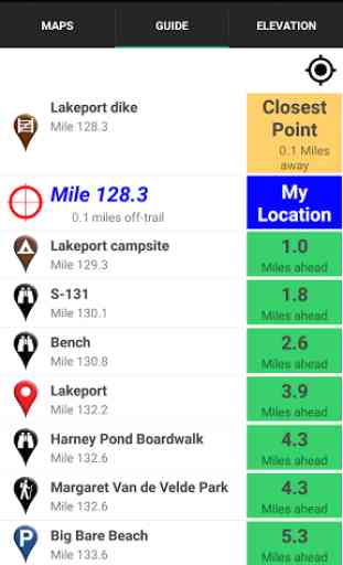
The guidebook lists every waypoint in order by distance along the trail and how far away you are from each waypoint.
Send your current location to friends and family via text message or e-mail.
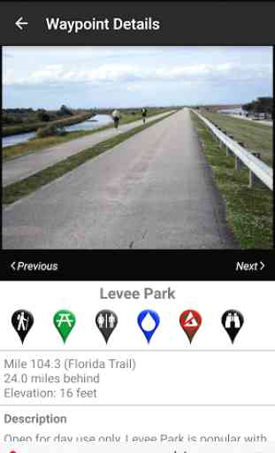
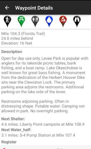
Each waypoint includes a detail page, providing further details about that particular waypoint. Details include the waypoint's mileage point and elevation, photographs of the waypoint, distance to the next water source and campsite, a Trail Register where you may post comments and read other users' comments, and other details that will help you during your hike, and help you plan your hike.
The types of waypoints include:
-->Water sources (including the reliability of each water source)-->Tenting sites/camping sites/shelters-->Trail junctions-->Parking areas along the trail-->Picnic areas, campgrounds, ranger stations-->Roads, railroad tracks, power lines-->Privies/restrooms-->Towns on the trail
Category : Travel & Local
Reviews (27)
I am thru hiking the Florida trail as of January 9th 2021. I've used the app exclusively for section hikes and the ocean to lake trail for two years prior. I love that the app can be updated with comments from other users so that the status of water sources and availability of resources is accurate. In addition to that this is a must have for thru hikers as it can be checked offline so as not to drain your phones batteries!
Suddenly stopped recognizing me. Tried to log in, no luck. Tried to reset password, didn't recognize my email. Thank goodness this happened AFTER I was off trail. Hate to think what might have happened if I was still out there hiking!
Almost unusable. The app crashes every time I try to add a route. I was hoping an update would fix this bug, but it has behaved this way for almost a year now.
not as accurate or informative as other atlas guides. Still the best way to navigate this trail.
Works well for both long distance backpacking and day hike planning. Helps to define the resources that are available to you
Everything I was expecting and needed for my outdoor trips. It really comes in handy.
Yes, offline navigation. Con not reserve hotels. Has a positive impact.
Perfect! I noted some minor discrepancies with the trails so far, but nothing lethal.
Works great! I've used it on the AT and the FT.
The app crashes constantly and will not let you create a route as advertised.
Great maps, easy to use. A boon for Florida Trail hikers!
I just purchased the whole Florida Trail maps package, how do I access it to update the App?
great, needs more camping spots, other trail options like WITHLACOOCHee state trail
Excellent resource. I would be toasted without it! Love it!
guthook's for FT. a fine app. worth it. you can do it. you can do this.
Super awesome app. Tells you where every little thing is.. Havent had any probs out of it..
Terrible. It's just a gateway to sell maps.
love the detail only wish ir gave you your latitude and longitude
Need to enable installing app and saving downloads to SD
Reliable, easy to use.
Great resource!! Thank you for this App!!!
Bait and switch. Horrible! Juncky app
Wants you to buy maps of trails.
Thought this would be a map of the Florida trail.
Great app i found stuff on this app i would have never found out by myself
Don't leave home without it
It would be impossible to thru hike the FT without this App! Terminus to Terminus is over 1,000 miles, or up to 1,500 miles if you were to hike all the side trails and optional routes! This app highlights HUNDREDS of waypoints that the official FTA interactive map does not show (i.e. water sources, even crucial camping areas). This app also allows comments of each waypoint, so hikers can leave feedback to help other hikers. App allows offline maps. This is a must have in your camping gear.