TKGM Parsel Sorgu
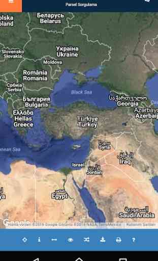
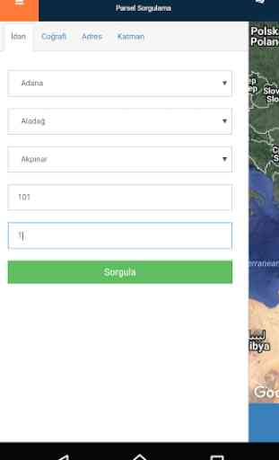
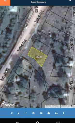
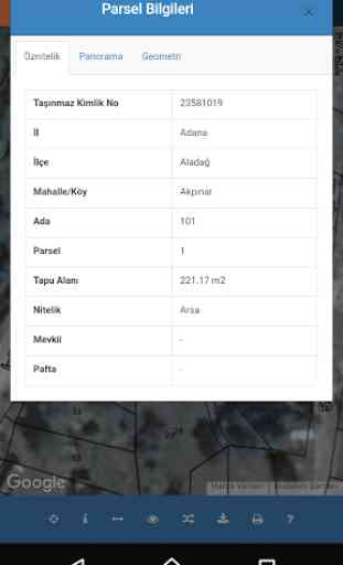
Türkiyedeki parsellerin çeşitli sorgu kriterlerine göre • İdari Sorgu( İl, İlçe, Mahalle, Ada, Parsel hiyerarşisi içerisinde)• Adres Sorgu ( Girilen adrese göre sorgulama)• Koordinat sorgu ( Girilen koordinat değerlerine göre sorgulama)• Harita üzerinden sorgulama ( Harita üzerinden seçilen koordinata göre sorgulama)sorgulanması ve bulunan parsellerin • Öznitelik bilgilerinino il, ilce, mahalle, ada ve parsel bilgilerio Yüzlöçüm bilgisio Pafta bilgisio Mevki bilgisio Nitelik bilgisi• Coğrafi bilgilerinino Koordinat bilgisigösterilmesi sağlanmaktadır.Bulunan parsellerin koordinat ve bilgilerinin uygulama üzerinden o Pdfo Kmlo Geo Jsonolarak indirilmesi sağlanmaktadırBulunan parsellere rota servis sağlayıcıları (Google map, Bing map, Yandex Map vs) ile rotalama yapılması sağlanmaktadırBilgilendirme
- Mekânsal Gayrimenkul Sistemi (MEGSIS) ile tapu ve kadastro bilgilerinin uyumlaştırılma çalışmaları ve kontrolleri kurumumuz tarafından yapılmaktadır.
- Bu uygulama ile MEGSİS kapsamında tapu verileri ile uyumlaştırılması tamamlanmış kadastro bilgilerine ait temel bilgiler sunulmaktadır.
- Görüntülenen kayıtlar ile elinizde bulunan bilgiler arasında uyumsuzluk olması halinde ilgili tapu ve/veya kadastro müdürlüğüne müracaat ediniz.
- Taşınmaza ait konum bilgileri test amacı ile yaklaşık koordinatlarla sunulmaktadır.
- BU UYGULAMADA SUNULAN BİLGİLER RESMİ VE TİCARİ AMAÇLI KULLANILAMAZ... According to various queries by the plots in Turkey
• Query Manager (provincial, district, neighborhood, Island, in the Parcel hierarchy)
• Address Query (inquiry based on the entered address)
• Coordinate queries (queries based on coordinates entered value)
• questioning over the map (query by coordinates selected on map)questioning and found parcels
• The attribute informationthat city, county, neighborhood, land registration and property informationMy information is that Yüzlöçhe Sheet informationo Location informationQualities that information
• Geographical Informationo Coordinate informationDisplay is provided.The information contained on the application of the coordinates and parcelit Pdfhe Kmlo Geo JsonIt is available to be downloadedFound route to the parcel service providers (Google map, map Bing, Yandex Map, etc.) are provided with routing doneInformation
- Spatial Property System (MEGSIS) and the harmonization of land registry and cadastre information studies and checks are carried out by our organization.
- With this application it will be aligned with MEGSİS data are presented under the title of completed basic cadastral information.
- If there is a mismatch between land related information with the records displayed in your hands and / or be referred to the cadastral office.
- Immovable property belonging to the location information is presented in approximate coordinates with the purpose of testing.
- THE INFORMATION PROVIDED IN PRACTICE AND COMMERCIAL PROPERTY USED IN OFFICIAL ...
Bulunan parsellerin koordinat ve bilgilerinin uygulama üzerinden o Pdfo Kmlo Geo Jsonolarak indirilmesi sağlanmaktadır
Bulunan parsellere rota servis sağlayıcıları (Google map, Bing map, Yandex Map vs) ile rotalama yapılması sağlanmaktadır
Bilgilendirme
- Mekânsal Gayrimenkul Sistemi (MEGSIS) ile tapu ve kadastro bilgilerinin uyumlaştırılma çalışmaları ve kontrolleri kurumumuz tarafından yapılmaktadır.
- Bu uygulama ile MEGSİS kapsamında tapu verileri ile uyumlaştırılması tamamlanmış kadastro bilgilerine ait temel bilgiler sunulmaktadır.
- Görüntülenen kayıtlar ile elinizde bulunan bilgiler arasında uyumsuzluk olması halinde ilgili tapu ve/veya kadastro müdürlüğüne müracaat ediniz.
- Taşınmaza ait konum bilgileri test amacı ile yaklaşık koordinatlarla sunulmaktadır.
- BU UYGULAMADA SUNULAN BİLGİLER RESMİ VE TİCARİ AMAÇLI KULLANILAMAZ...
The information contained on the application of the coordinates and parcelit Pdfhe Kmlo Geo JsonIt is available to be downloaded
Found route to the parcel service providers (Google map, map Bing, Yandex Map, etc.) are provided with routing done
Information
- Spatial Property System (MEGSIS) and the harmonization of land registry and cadastre information studies and checks are carried out by our organization.
- With this application it will be aligned with MEGSİS data are presented under the title of completed basic cadastral information.
- If there is a mismatch between land related information with the records displayed in your hands and / or be referred to the cadastral office.
- Immovable property belonging to the location information is presented in approximate coordinates with the purpose of testing.
- THE INFORMATION PROVIDED IN PRACTICE AND COMMERCIAL PROPERTY USED IN OFFICIAL ...
- Mekânsal Gayrimenkul Sistemi (MEGSIS) ile tapu ve kadastro bilgilerinin uyumlaştırılma çalışmaları ve kontrolleri kurumumuz tarafından yapılmaktadır.
- Bu uygulama ile MEGSİS kapsamında tapu verileri ile uyumlaştırılması tamamlanmış kadastro bilgilerine ait temel bilgiler sunulmaktadır.
- Görüntülenen kayıtlar ile elinizde bulunan bilgiler arasında uyumsuzluk olması halinde ilgili tapu ve/veya kadastro müdürlüğüne müracaat ediniz.
- Taşınmaza ait konum bilgileri test amacı ile yaklaşık koordinatlarla sunulmaktadır.
- BU UYGULAMADA SUNULAN BİLGİLER RESMİ VE TİCARİ AMAÇLI KULLANILAMAZ... According to various queries by the plots in Turkey
• Query Manager (provincial, district, neighborhood, Island, in the Parcel hierarchy)
• Address Query (inquiry based on the entered address)
• Coordinate queries (queries based on coordinates entered value)
• questioning over the map (query by coordinates selected on map)questioning and found parcels
• The attribute informationthat city, county, neighborhood, land registration and property informationMy information is that Yüzlöçhe Sheet informationo Location informationQualities that information
• Geographical Informationo Coordinate informationDisplay is provided.The information contained on the application of the coordinates and parcelit Pdfhe Kmlo Geo JsonIt is available to be downloadedFound route to the parcel service providers (Google map, map Bing, Yandex Map, etc.) are provided with routing doneInformation
- Spatial Property System (MEGSIS) and the harmonization of land registry and cadastre information studies and checks are carried out by our organization.
- With this application it will be aligned with MEGSİS data are presented under the title of completed basic cadastral information.
- If there is a mismatch between land related information with the records displayed in your hands and / or be referred to the cadastral office.
- Immovable property belonging to the location information is presented in approximate coordinates with the purpose of testing.
- THE INFORMATION PROVIDED IN PRACTICE AND COMMERCIAL PROPERTY USED IN OFFICIAL ...
Bulunan parsellerin koordinat ve bilgilerinin uygulama üzerinden o Pdfo Kmlo Geo Jsonolarak indirilmesi sağlanmaktadır
Bulunan parsellere rota servis sağlayıcıları (Google map, Bing map, Yandex Map vs) ile rotalama yapılması sağlanmaktadır
Bilgilendirme
- Mekânsal Gayrimenkul Sistemi (MEGSIS) ile tapu ve kadastro bilgilerinin uyumlaştırılma çalışmaları ve kontrolleri kurumumuz tarafından yapılmaktadır.
- Bu uygulama ile MEGSİS kapsamında tapu verileri ile uyumlaştırılması tamamlanmış kadastro bilgilerine ait temel bilgiler sunulmaktadır.
- Görüntülenen kayıtlar ile elinizde bulunan bilgiler arasında uyumsuzluk olması halinde ilgili tapu ve/veya kadastro müdürlüğüne müracaat ediniz.
- Taşınmaza ait konum bilgileri test amacı ile yaklaşık koordinatlarla sunulmaktadır.
- BU UYGULAMADA SUNULAN BİLGİLER RESMİ VE TİCARİ AMAÇLI KULLANILAMAZ...
The information contained on the application of the coordinates and parcelit Pdfhe Kmlo Geo JsonIt is available to be downloaded
Found route to the parcel service providers (Google map, map Bing, Yandex Map, etc.) are provided with routing done
Information
- Spatial Property System (MEGSIS) and the harmonization of land registry and cadastre information studies and checks are carried out by our organization.
- With this application it will be aligned with MEGSİS data are presented under the title of completed basic cadastral information.
- If there is a mismatch between land related information with the records displayed in your hands and / or be referred to the cadastral office.
- Immovable property belonging to the location information is presented in approximate coordinates with the purpose of testing.
- THE INFORMATION PROVIDED IN PRACTICE AND COMMERCIAL PROPERTY USED IN OFFICIAL ...
Category : Communication
Related searches
Reviews (3)
Khu. K.
Jan 9, 2022
I can't open this application, getting response " error occurred ".
Abd. D.
Aug 12, 2021
Excellent app thanks
Excellent app for local use. Recommended especially if looking to buy land or property.