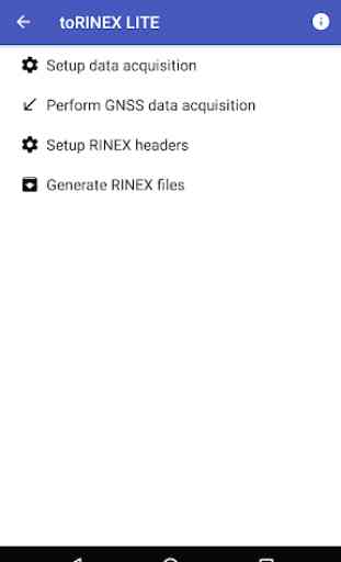
to RINEX Lite
The application generates Receiver INdependent EXchange Format (RINEX) files from Global Navigation Satellite Systems (GNSS) raw data acquired from the smartphone GNSS receiver.
To do it, the user is allowed to setup the parameters for raw data acquisition, to save observation and navigation raw data in files, to setup the metadata and parameters to generate RINEX files, and to perform the conversion from raw data to RINEX.
The application stores the raw data and RINEX files in the Documents public directory for its further exploitation.
Availability of observation and navigation data for the different systems, like GPS, GLONAS, GALILEO, SBAS, etc, will depend on smartphone receiver characteristics. GPS satellites L1 pseudorange, doppler and signal strength observables are available from all smartphone receivers, but other observables and the navigation message data only from some receivers.
Each acquisition of GNSS raw data is performed with the receiver/phone placed in a fixed point. Observation data collected in a given point will be stored in an Observation Raw Data file. The set of files containing measurements from several related points are grouped in a survey. Navigation data collected during a survey are stored in a Navigation Raw Data file.
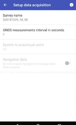
The user can select the number of epochs and the epoch interval for each data acquisition.
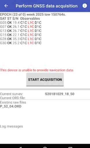
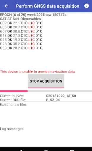
To allow user control on the acquisition process, the app shows the status of all satellites being tracked (satellite identification, signal quality, observables available) and the epoch time (GPS week and Time Of Week). Acquisition will start when the user click the Start Acquisition button, and finish when the preselected number of epochs have been received, or the acquisition aborted.
This app requires at least Android 7.1 (API level 25), which is the first providing GNSS raw data measurements.
When acquisition has finished the user has to setup the metadata to be included in RINEX headers. Also the user can provide parameters that would affect filtering of data to be used to generate the files, like constellations, satellites and observables.
To generate RINEX files the user selects the the raw data files to be used and if the resulting file or files would contain data for one point or for several separated by"new site occupation" event records.
All files generated by the application are text files. A file manager and a text editor can be used to manage and display them.
This LITE version does not include the following functionalities:
- On acquisition setup: the number of epoch to acquire per point is fixed to 10, and the option to acquire navigation data is always off.
- On RINEX setup: Only mandatory metadata can be introduced.
To do it, the user is allowed to setup the parameters for raw data acquisition, to save observation and navigation raw data in files, to setup the metadata and parameters to generate RINEX files, and to perform the conversion from raw data to RINEX.
The application stores the raw data and RINEX files in the Documents public directory for its further exploitation.
Availability of observation and navigation data for the different systems, like GPS, GLONAS, GALILEO, SBAS, etc, will depend on smartphone receiver characteristics. GPS satellites L1 pseudorange, doppler and signal strength observables are available from all smartphone receivers, but other observables and the navigation message data only from some receivers.
Each acquisition of GNSS raw data is performed with the receiver/phone placed in a fixed point. Observation data collected in a given point will be stored in an Observation Raw Data file. The set of files containing measurements from several related points are grouped in a survey. Navigation data collected during a survey are stored in a Navigation Raw Data file.
The user can select the number of epochs and the epoch interval for each data acquisition.
To allow user control on the acquisition process, the app shows the status of all satellites being tracked (satellite identification, signal quality, observables available) and the epoch time (GPS week and Time Of Week). Acquisition will start when the user click the Start Acquisition button, and finish when the preselected number of epochs have been received, or the acquisition aborted.
This app requires at least Android 7.1 (API level 25), which is the first providing GNSS raw data measurements.
When acquisition has finished the user has to setup the metadata to be included in RINEX headers. Also the user can provide parameters that would affect filtering of data to be used to generate the files, like constellations, satellites and observables.
To generate RINEX files the user selects the the raw data files to be used and if the resulting file or files would contain data for one point or for several separated by"new site occupation" event records.
All files generated by the application are text files. A file manager and a text editor can be used to manage and display them.
This LITE version does not include the following functionalities:
- On acquisition setup: the number of epoch to acquire per point is fixed to 10, and the option to acquire navigation data is always off.
- On RINEX setup: Only mandatory metadata can be introduced.
Category : Tools
Related searches