TopoNavigator Greece topo maps
New feature: become a beta tester and get early access to new features: https://play.google.com/apps/testing/anadigit.toponavigator.maps
The free version offers:
MAPS
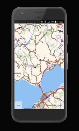
• Offline map tiles downloading & caching (including Greek Cadastre aerial photos, OSM, Google & Bing Maps) on internal or external memory (micro SD card)
• Map downloading along 1 or more selected tracks or routes.
• Offline maps management page with the possibility to delete a specific map on a specific level
• Map Rotate, Tilt & Zoom with multitouch gestures
• Greek Geodetic Reference System (GGRS87) coordinates
• Auto or manual map scaling to improve map legibility on high-resolutions screens
• Speed-related map rotation auto-switch based either on compass or GPS heading
• Combined speed-related Auto-Zoom & Auto-Tilt (3D perspective view) with 3 profiles (Travel, Offroad, Extreme 4x4)
• Continuous Speed, Elevation, GPS Accuracy & Slope charts when a GPS is connected
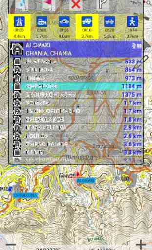
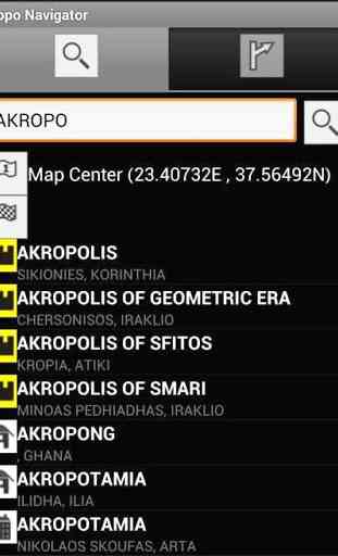
• Offline search for 200000 woldwide cities including 20000 nameplaces, 1900 archaelogical sites & 1400 monasteries in Greece
ROUTING
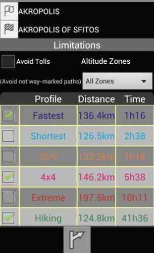
• Online routing for Greece. Options include fastest & shortest route, altitude zone, toll avoidance.
• Start & destination positions can be set either on map, GPS fix, using long press on map, search, coordinates or waypoints. Navigation points can be deleted or modified.
• Unlimited number of routes can be stored for offline use.
DATA
• Digitalization of lines and points with a finger, mouse or stylus.
• Edit lines on your device: click to add a vertex, drag a vertex to move it, long press on a vertex to create waypoint, delete it or split the line.If 2 lines are selected, use the popup to join the 2 selected lines or delete them.
• Ability to set a solid symbol for lines or choose from 5 color palettes interpreting speed, slope, elevation, pace and accuracy Equal Intervals analysis.
• Unlimited waypoint capture on or off GPS fix. Create, edit or delete waypoint. Move points to GPS fix, to the map center or with drag & drop.
• Unlimited track recording with custom time & distance intervals. Recording line symbol uses a 4-color palette to display GPS accuracy. Track statistics include elevation & speed graphs, duration, min, max & avg speed, min & max elevation, total ascent & descent, 2D & 3D length
• Import & export waypoints & tracks on KML, KMZ & GPX formats.
• After exporting data, you can share the file with Dropbox, Google Drive, email...
• Simplify tracks on save. Options include: no generalization, mild (1m tolerance), moderate (3m) and strong (6m) generalization.
INTERFACE
• 4 languages (english, greek, french & german)
• Direct link to TopoNavigator GPS Info free app that gives satellite info, visualizes pitch & roll values, records NMEA sentences, sends position by SMS or e-mail & offers an advanced Trip Computer
The paid version (TopoNavigator Extreme, 40€ one-time purchase for 3 devices):
• gives access to TopoNavigator maps & offers 6 routing profiles (Fastest, Shortest, SUV, 4x4, Extreme 4x4 and Hiking).
TopoNavigator maps are considered by many the best maps of Greece for any outdoor adventure activity (hiking, 4x4 driving, mountain bike) and includes 20m contour lines.
The maps are available in Greek & Latin characters and cover all regions of Greece: Athens and Attica, Central Greece, Peloponnese (Southern Greece), Epirus, Macedonia & Thrace (Northern Greece), Cyclades, Ionian, Dodecanese & Creta (Kriti) islands.
• Points & lines digitized on screen (off GPS fix) get elevation values from a high accuracy 30m cell Digital Elevation Model (currently DEM is server-based and only covers Greece).
To view TopoNavigator maps visit: http://www.topoguide.gr/index-map.php
Category : Travel & Local
Reviews (5)
Have been using this app since 2012 (obviously an older version back then) and was very satisfied. The issues encountered mostly had to do with some of the map tiles that were saved in my device which didn't show on the screen; I used to think that this may be my device's problem so never made an issue out of it. Today, though, I started the app and none of the map tiles (all 62GB saved on my device) show. Apparently the company has issued a new version and with it they have locked the use of maps which may be unlocked only after buying the full version of the app. In other words this is not a free app in more. I am not naive, I totally get it when a company wants to capitalise on their investment, but what if a person using the free app woke up a morning in the wilderness only to find that their navigation tool is free no more, so they essentially have no means of electronic navigation any more... A little thoughtfulness on the company's behalf would have gone a long way...
Not just a map, but a real tool!
Η ΑΠΟΛΥΤΗ ΕΦΑΡΜΟΓΗ ΓΙΑ offroad. ΠΟΛΛΑ ΣΥΓΧΑΡΙΤΗΡΙΑ ΣΤΗΝ ANADIGIT ΓΙΑ ΑΥΤΗ ΤΗΝ.ΥΠΕΡΟΧΗ ΕΦΑΡΜΟΓΗ. ΔΟΚΙΜΑΣΤΗΚΕ ΚΑΤΩ ΑΠΟ ΠΡΑΓΜΑΤΙΚΕΣ ΣΥΝΘΗΚΕΣ
There are better apps for this. Wikiloc or kommot beat this easily
You sell a product targeting people that do outdoor sports to remote locations usually with no internet connection and you do require an internet connection for your product to work. That's an awful business model. I used this app twice and both times I had to use another app in order to continue my route due to missing map tiles. I can't rely on this app so I consider the money I spent wasted. I only rate with two stars because of the maps. Pros: - good maps Cons: - needs data connection to work - needs like a hell of a lot storage for the maps - consumes like hell of a lot data to get the underlying maps - bit buggy in my device - slow as hell when loading a lot of data - no navigation - cannot search for POIs