Track It Finder Map
With Track-It-Finder you can save your path to a map track. Tracks can be marked with way point description, and time stamps. Google Street View (visual panoramas), Places, GeoJson, and (Google Earth data formats) KML/KMZ data can be opened up in the app.
Multiple layers (files or URLs) can be loaded into the map and stacked up with the track information so you can get a feature rich mash up with everything you need in one app. The last URL used is saved in the preferences so the next time you bring up the app you can get the mash up of the current data once again by loading it without having to re-enter. The last data file (geojson / kml / kmz / gpx ) you opened will be remembered so it will automatically come up the next time you bring up the app.
Find what is near you by search (Places) or sight (Street View), or integrate with Google Navigator to provide turn-by-turn routing and directions if you are in a hurry. Also, a Data table containing all Markers, Way points, photos, and Places available on the map can be displayed. You can go to that location on the map by Long-Clicking on the row in the table.
The application uses Google's fused location provider supporting both inside and outside positioning. Location is provided in a background service that will record the most accurate, and unique GPS coordinates for use in the map application. Location updates are provided even when your screen is turned off or you are indoors when you enable Tracking. Once the screen is turned back on the app will add all the accumulated points right back into you map when the next GPS location is received.
The application imports Google Earth KML/KMZ, and GeoJson data files or URLs and can read and write GPX data format tracks and way points. Multiple data files can be loaded to layer the information together in the same map. Marker data Clustering is also supported for KML data to make extra large data sets easier to visualize. Way point names and Types, Time, and Elevations are supported in the GPX tracks. The application calculates the distance traveled, trip duration, and estimated (walking) Kilo-Calories burned when using GPX tracks. The main map can be displayed in the standard Google Street, Terrain, and Satellite view modes.
The app also provides textual searching of way point names, and map markers or places data. And integrates Google Contacts via direct dialing of the phone numbers (Long-click on the places icon in the map, or directly from the search results). The places found can be directly added to your Contacts and visually displayed by a marker on the map.
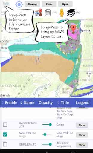
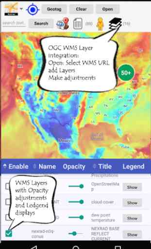
WMS Layers
Web Mapping Services (OGC WMS) layers can be added to you map by clicking the Open Button and selecting "Use URL". The "Open URL" button shows the layer list for that service. I.e. USGS has WMS sites for the states ( https://mrdata.usgs.gov/services/ny ). You select the layers you want by checking the boxes and clicking "ok". Once the layers have been added click on the layers icon in the app and set the Enable checkbox and transparency slider to see the layer. Note: new WMS layers are not enabled (unchecked) and transparent by default. Long-Click the Layer icon to edit all the WMS layers in the app.
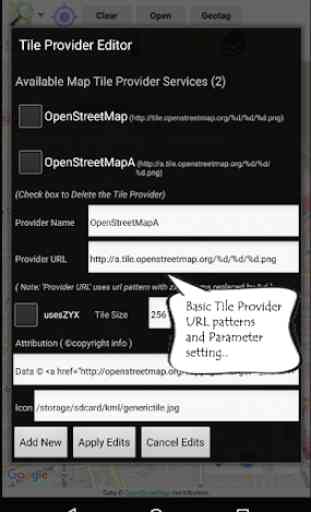
Map Tile Service Providers (XYZ format)
You can Long-Click the Map Types icon in the app to edit/add providers. I.e. to add OpenStreetMap url: http://tile.openstreetmap.org/%d/%d/%d.png (where %d is the pattern for xyz number). You can add an icon, set tile sizes, token ids (i.e. apikey), and attribution (copyright) as well. Please make sure you comply with the tile service conditions and rules.
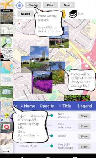
Photo GeoTags
Photographs with latitude/longitude EXIF data can show up on the map via clicking the 'Geotag' button in the app. These photos are usually found in the DCIM directory on your phone. You can change the location used by Long-Clicking the Geotag button. A KML file is also produced in the kml directory: TrackItFinderPhotoGeoTags_{date}.kml.
Multiple layers (files or URLs) can be loaded into the map and stacked up with the track information so you can get a feature rich mash up with everything you need in one app. The last URL used is saved in the preferences so the next time you bring up the app you can get the mash up of the current data once again by loading it without having to re-enter. The last data file (geojson / kml / kmz / gpx ) you opened will be remembered so it will automatically come up the next time you bring up the app.
Find what is near you by search (Places) or sight (Street View), or integrate with Google Navigator to provide turn-by-turn routing and directions if you are in a hurry. Also, a Data table containing all Markers, Way points, photos, and Places available on the map can be displayed. You can go to that location on the map by Long-Clicking on the row in the table.
The application uses Google's fused location provider supporting both inside and outside positioning. Location is provided in a background service that will record the most accurate, and unique GPS coordinates for use in the map application. Location updates are provided even when your screen is turned off or you are indoors when you enable Tracking. Once the screen is turned back on the app will add all the accumulated points right back into you map when the next GPS location is received.
The application imports Google Earth KML/KMZ, and GeoJson data files or URLs and can read and write GPX data format tracks and way points. Multiple data files can be loaded to layer the information together in the same map. Marker data Clustering is also supported for KML data to make extra large data sets easier to visualize. Way point names and Types, Time, and Elevations are supported in the GPX tracks. The application calculates the distance traveled, trip duration, and estimated (walking) Kilo-Calories burned when using GPX tracks. The main map can be displayed in the standard Google Street, Terrain, and Satellite view modes.
The app also provides textual searching of way point names, and map markers or places data. And integrates Google Contacts via direct dialing of the phone numbers (Long-click on the places icon in the map, or directly from the search results). The places found can be directly added to your Contacts and visually displayed by a marker on the map.
WMS Layers
Web Mapping Services (OGC WMS) layers can be added to you map by clicking the Open Button and selecting "Use URL". The "Open URL" button shows the layer list for that service. I.e. USGS has WMS sites for the states ( https://mrdata.usgs.gov/services/ny ). You select the layers you want by checking the boxes and clicking "ok". Once the layers have been added click on the layers icon in the app and set the Enable checkbox and transparency slider to see the layer. Note: new WMS layers are not enabled (unchecked) and transparent by default. Long-Click the Layer icon to edit all the WMS layers in the app.
Map Tile Service Providers (XYZ format)
You can Long-Click the Map Types icon in the app to edit/add providers. I.e. to add OpenStreetMap url: http://tile.openstreetmap.org/%d/%d/%d.png (where %d is the pattern for xyz number). You can add an icon, set tile sizes, token ids (i.e. apikey), and attribution (copyright) as well. Please make sure you comply with the tile service conditions and rules.
Photo GeoTags
Photographs with latitude/longitude EXIF data can show up on the map via clicking the 'Geotag' button in the app. These photos are usually found in the DCIM directory on your phone. You can change the location used by Long-Clicking the Geotag button. A KML file is also produced in the kml directory: TrackItFinderPhotoGeoTags_{date}.kml.
Category : Travel & Local
Related searches