US Public Lands
- almost 30 percent of the land area of the United States.
These are lands that are held for all Americans.
Up until now, there has been no quick & easy way to retrieve the boundaries of these properties without carrying physical maps, books, or slowly digging deep online.
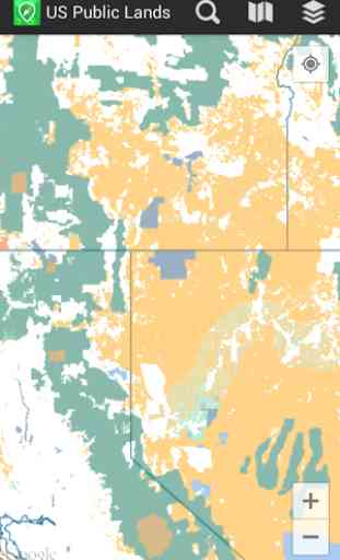
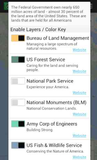
Included in this app are on device (fully works offline), individually selectable & beautifully colored layers for all of the properties administered by the federal government that are more than 640 acres in size:
- Bureau of Land Management (BLM)
- US Forest Service (FS)
- National Park Service (NPS)
- BLM
- National Monuments
- Army Corp of Engineers (ACOE)
- US Fish & Wildlife Service
- Bureau of Reclamation
- Tennessee Valley Authority
- Department of Defense (military bases & installations)
- Other (National Laboratories, Test Sites, etc...)
Key Benefits & Features
- Know which US agency owns and operates the land you're on or are heading to. Use the "Layers" icon to select which agencies you want displayed to create your own custom map. (Hint, the toggles are color coded to the color each layer is displayed in.)
- Links are provided to each agency's website within the app, so that you can further your research as to what land use rules apply for each public land type
- such as permits, fees, activities allowed, and limits of stay.
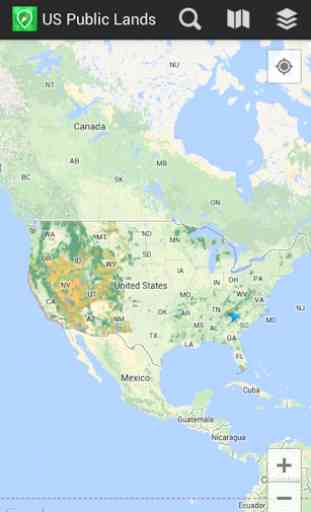
- Map layers are stored on device
- no internet connection required.
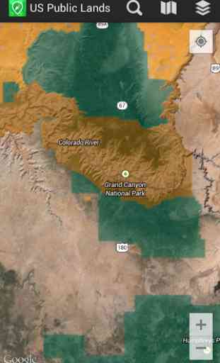
- Be sure to turn on the 'Basic' base map to see the US Public Land labels for each land area. This base map layer is also stored entirely on your device, and can be utilized if you do not have an internet connection or would like to conserve bandwidth.
- If you have an internet connection, you can utilize standard and satellite view maps as well as the base layer underneath the public land overlays.
- A boondocker's assistant
- by turning on the Satellite view map, you can better scout out trails, roads and boondock camping locations within the boundaries of the public land resources. (Please note, this is not specifically a campground locator app
- but you can combine the boundary maps with satellite imagery to scout out where there are clearings and signs of dispersed campsites. For an example of how this app can help with finding boondocking locations, see: http://www.technomadia.com/2014/09/finding-magical-boondocking/)
- Quickly toggle between 'Show' and 'Hide' via the "Map" icon to more clearly see satellite images below.
- If you have GPS access on your device, click the 'Locate Me' icon to show your present location
- know what type of land you're on right now!
- Built in search tool locates anything on device maps supports (requires internet access)
- including cities, states, zip codes, addresses and points of interest. A pin is dropped at the search location.
Now the US Public Land boundaries can be in your pocket!
Thank you to the National Atlas of the United States for providing public domain raw map data that we’ve been able to apply our proprietary rendering technology to create an interactive overlayable mapping & navigation tool. We will update our maps, when they update they theirs.
Please note, the National Atlas maps only report to the nearest 640 acres (or about a square mile). This is obviously not detailed enough to be precise around borders, or for determining where private inholdings within public lands are located. US Public Lands should only be used as an overview, and you should always confirm more precise details by consulting more detailed maps, local field offices or the websites links with in the app. And we of course can make no guarantees as to the accuracy of the maps provided by the National Atlas.
Category : Travel & Local
Reviews (22)
It could be a good app but accuracy isn't it's strong suite...For example, I'm presently on private property and surrounded by numerous pieces of private property yet it's showing this entire area as national forest...theres also an annoying blur on the edges of the layers making it difficult to tell where the boundary actually lies; when zoomed out, thats great to look at but zoomed it, the true boundaries are vague to say the least...
Great data, so-so application.. the maps feature doesnt have any usable map saved for offline use.. even parts you've already looked at won't cache and be available when your offline. It's an amazing app for but could still be a lot better.
Helpful to check camping sites and when traveling on remote roads. Adding Arizona State Trust lands would be very helpful.
Comparing this to other apps, which are free, this has less functionality. Doesn't do anything besides show regions/blm/other/etc. Nothing to see here.
Don't drop pins there is no clear way to remove them . Can't find anyway to clear a drop pin or to clear list of pins.
Used the app on a brand new note 20 ultra 9/15/20. It doesn't work no information loads on the map. Garbage 🗑
Almost useless. Not much information. Interface is ugly.
Very cool app. to have helps u know whether u are on public or private lands
This app does not load just continues to try to install and never installs
Very useful for van camping
Pretty nice thing to have. If you boondock you will really like this.
this is an awesome way to figure out where to camp / boondoggle!
This app works in the mountains when nothing else does
No useful info at all. Waste of money.
Great way to find general boundaries of public land. Just gotta use common sense when camping so you don't wander onto private land.
The very first area I checked was totally inaccurate. I think I'll hit refund.
Just plain wrong. Massive off limits areas marked as public, and tons of public lands are not shown. Only well known fed land shown, lots of state and other local public lands missing.
This is a great App. It saves us $$$ Every time we use it. Well worth it's cost.
This app is so inaccurate it will get you in trouble. The overlays show major ranches in my area as being on BLM land which are not. It also shows one of the most popular public lakes here as being on private land which is not so. Don't count on it in any way or you may find yourself with trespassing charges. I want my money back
I read all the bad reviews but decided to buy it anyway. I can't fully test it yet because my reception is so poor. I'll update my review after I've used it for awhile.
My wife and I love the app. You should add Indian Reservation lands, it would have been a huge help to my wife and I recently.
This app is a great way to see if the land where I am or I'm going has places I can camp for free. I like that it seems to work even with no cell coverage. The one thing I'd change if I could would be to choose which part of the US I'd like data files downloaded for. My phone doesn't have a huge amount of memory, and this app uses a lot, I assume for the great data file.