US Topo Maps Pro
Choose between >20 map layers (topos, aerials, sea charts, flight maps, ...)
Turn your Andoid Phone/Tablet into an outdoor GPS for trips into the backcountry without cell coverage. This app gives you similar mapping options as you might know from Garmin or Magellan GPS handhelds.
Premium email support
- we'll answer your questions within 24 hours
Main features for outdoor-navigation:
• Download of map tiles for OFFLINE USAGE (not for Google and Bing maps)
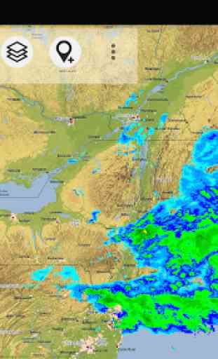
• Display Real-Time nowCoast Weather Information and NEXRAD Weather Radar (animated)
• Free access to more than 100.000 seamlessly stitched USGS topographic maps
- easy to use as browsable map layer
• Create and edit Waypoints
• GoTo-Waypoint-Navigation
• Create and edit Routes
• Route-Navigation (Point-to-Point Navigation)
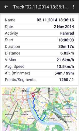
• Track Recording (with speed, elevation and accuracy profile)
• Tripmaster with fields for odometer, average speed, bearing, elevation, etc.
• GPX/KML/KMZ Import/Export
• Search (placenames, POIs, streets)
• Customizable datafields in Map View and Tripmaster (e.g. Speed, Distance, Compass, ...)
• Share Waypoints, Tracks or Routes (via eMail, Dropbox, Facebook, ..)
• Use coordinates in WGS84, UTM or MGRS/USNG (Military Grid/ US National Grid)
• Get NWS Weather Forecast
• Track Replay
• and many more ...
Available map layers:
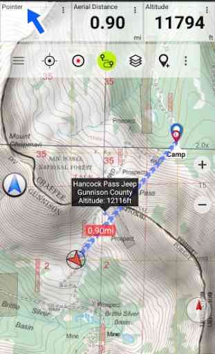
• USGS DRGs: Seamless coverage of topo maps of the USA at Scales 1:250.000, 1:100.000, 1:63.000 and 1:24.000/25.000
• New US Topo maps
• USGS High Resolution aerial imagery
• USGS National Map
• NAIP Orthoimagery for conterminous US
• Google Maps (Satellite images, Road
- and Terrain-Map)
• Bing Maps
• Open Street Maps
• FSTopo Forest Maps
• NOAA Nautical RNC Charts
• Flight Maps
• Public Land Ownership (Padus)
• Earth At Night
Available map overlays:
• Hillshading
• Ridge Weather Radar NWS
• Wind, Temperature, Pressure
• Wind Vectors
• Precipitation Estimate
- 1-hr
• Precipitation Forecast 24h
• Surface Air Temperature
• Hazard Warnings
• Tropical Cyclone Track
• Wind Vector Forecast 24h
• Max. Air Forecast 24h
• Min. Air Forecast 24h
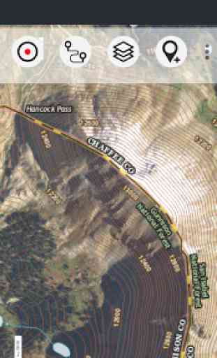
USGS DRG topographic maps:The 7.5-minute maps (1:24.000/1:25.000) are the best maps for outdoor activities in the USA. Although some of the maps are quite old, they contain many small pathes and 4WD tracks that are missing in new USTopos, Google, Bing and OSM maps.DRGs (Digital Raster Graphics) were produced from 1995 to 2001 by U.S. Geological Survey. DRGs have been made for all quadrangles in the USGS map series.
New US Topo Maps:US Topo maps are a graphic synthesis of The National Map data files and are produced in the familiar 7.5-minute by 7.5
- minute geographic format. Current US Topo map layers include an orthoimage base, transportation, geographic names, topographic contours, boundaries, hydrography and woodlands. Also included are the Public Land Survey System (PLSS) and the United States National Grid.
NAIP Orthoimagery:Seamless coverage of contiguous US with 1m/pixel resolution
HRO aerial imagery: High resolution arial photos covering US urban areas and borders (up to 10cm/pixel)
Use this navigation app for outdoor activities like hiking, biking, camping, climbing, riding, skiing, canoeing, hunting, offroad 4WD tours or search&rescue (SAR).
Import/Export/Share GPS-Waypoints/Tracks/Routes in GPX or Google Earth KML/KMZ format.
View Real-time nowCoast weather information like temperature or windvectors and overlay to map.
See animated NEXRAD rain radar to make accurate predictions when raining will start/stop.
Preload FREE map data for areas without cell service.
US topographic maps are enhanced with Atlogis® hillshading and placenames.
Free version available.
Comments and feature requests to [email protected]
Category : Maps & Navigation
Reviews (10)
I love this app and all of you. That's always there for me when I go on walks in the woods marking waypoints for those delicious mushrooms. And then over the years exporting the data and importing it when I can install the same app on a new device and have all my secret spots restored. Fantastic well worth the 12 bucks or whatever I spend on it years ago. I've had this app on a Nexus 4 a Samsung S8, a pixel XL and now a crummy Moto g and it still serves me well. Please don't stop maintenance❤️
Normal map issues regarding up to date details, but over all very useful and fun. I'm a "mapfreak" and enjoy your product. Sometimes my route goes in to "checker board" land, but usually good. I down load to my computer and get a slightly different processed map, but it is good stuff.
I've been very disappointed in this app. I cannot easily mark my position . If I try to expand with two fingers it immediately springs back to previous zoom. You have to use the + / - on the screen to zoom.
Really good up to date maps, but do have to pay careful attention to cell coverage. And maps don't help with where they won't be available.
After using this for several years, it is still the best map app I have found. One question, it used to default to sorting waypoints alphabetically, but now it's by most recently added. How do I change it back?
I love the unlimited waypoints and the variety of different map types. The only issue is if you look at other waypoints, you have to quit and reopen it to begin GPS navigation. I belong to an outdoors FB group and many won't even recognize or recommend this because they've had bad luck with it
Almost works. Waiting for the obvious. Bought another GPS app. If you don't ever want to zoom in close, then this is the app for you. Actually, you can, but as soon as you let either finger go, it zooms out to where some marketing dude figured you wanted it to be. Frustrating doesn't begin to describe the experience. Why not let the user decide what zoom level we want?????
As an offroader and amateur prospector this app is critical to my research and planning. I especially like the fact that you can add notes to your waypoints without overwriting the coordinates. I also like the new offline caching visual progress display. It gives you an idea of how the algorithm works and why it may not be a good idea to download a huge area all the way down to the last layer, no matter how large your SD card is (depends on the map). Keep up the great work.
This is an excellent GPS mapping app. I use it for off-road motorcycle trail riding on DNR / National Forest land. The app is super easy to use with many options to pick from. When one wrong turn can lead to a cold night spent in the wilderness or worse, why would anyone ever go to into the woods with US Topo Maps Pro???
A great app for offline map use. A lot of choices for maps, routes, waypoints, etc. So many choices it requires dedicated time just to figuring out the best set up for various uses. Found this as a replacement to the View Ranger app which was bought out and is no longer a good option for offline uses. So far this app has been a great replacement and has features that go beyond the View Ranger (and some that don't). Overall very satisfied!