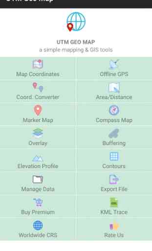
UTM Geo Map
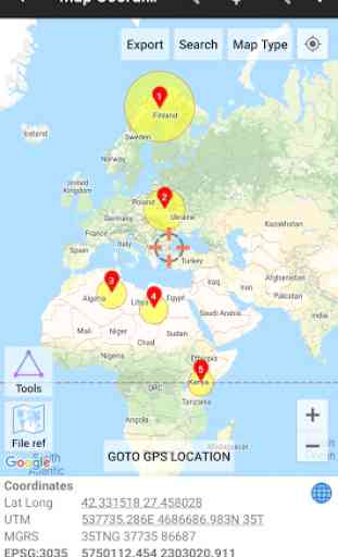
Map Coordinates: Can be used to obtain Latitude Longitude, UTM, MGRS (WGS84) & other CRS (using EPSG codes) in real time, register points complete with coordinate data, time taken, notes/labels, elevation (premium), addresses, photos etc. This module can also display TIN, Voronoi Diagrams and Buffers in realtime from existing points.
Offline GPS: Used to get coordinates in an offline state (without internet access), your cellphone will function like a Handheld GPS to get Latitude Longitude coordinates, UTM, MGRS, Elevation (ellipsoid), MSL Elevation (EGM96), accuracy, satellite and other useful information. Coordinates data can be stored in an unlimited number inside your databases, given notes / labels, photos or exported into CSV, KML, DXF & GPX formats.
Coord. Converter: To convert coordinates manually from Latitude Longitude to UTM & MGRS and vice versa. It can also be used to convert addresses to coordinates (Geocoding, requires an internet connection). Some conversion is support for batch conversion.
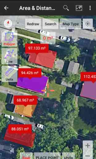
Area/Distance: Used to measure distance and area (support units: m, km, ft, miles, hectare, acre), register lines / polygons, make polygons automatically from measure points, create buffers from lines / polygons, overlay etc.. Line / polygon data can be stored in unlimited number inside your database, displayed on a map, added photos and labels or exported to CSV, KML or DXF format. Equipped with spatial editing algorithms such as Snap Nearest, Delete Object Inside / Outside Polygon, Smoothing (cubic bezier interpolation), Split Polygon By Line, and so on. Can read CSV & KML formats to import or display as reference files.
Marker Map: Similar to the Map Coordinates module but with more complete & complex geometry calculation such as displaying Dynamic / Variable Buffers. In this module geometric analysis such as TIN & Voronoi Diagrams can be made from a combination of point data (markers) as well as lines and polygons (breakline). These geometries can also be exported to KML or DXF files for use on other devices or PC.
Compass Map: A module with a map and compass, can be used to assist in navigating or measuring the azimuth angle and determining distance & direction. Equipped with Magnetic Declination data which can be directly corrected to the compass direction.
Overlay: Used to specifically perform overlay operations with several options including Union, Intersection, Difference and SymDifference.
Buffering: Used to specifically perform Buffering operations (creating buffer map) from point, line and polygon data obtained from measurements using other modules.
Elevation Profile: Used to create simple elevation profiles (cross section / long section) from height data with metric & ft / mile units. This module can also create elevation profiles from multiple points including elevation profile from route (premium).
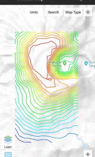
Contours: Module to generate contours based on number of contour lines, desired elevation or contour interval. This is premium modul & need internet connection.
Some other modules: Manage Data, Export File, Buy Premium and Trace KML.
Quick guide (pdf): http://www.yogantara.info/utmgeomapquickstart.pdf
YouTube: https://www.youtube.com/channel/UCspxQ5nQiqRD88g_-6GcCqw
Website: http://www.yogantara.com
Any suggestions are welcome, please submit via email to [email protected] or write a review. Thanks.
Category : Maps & Navigation
Reviews (28)
I think this app it's totally wonderful. It works off line, it could get the signal of a great number of satellites, you can make a different kind of task in a easily way.
Based on my experience, depending on phone model and usage/application, this app will substitute an RTK in survey field work. Be patient, learn its ins and outs and you will conceivably find every tool you need, in your smart phone, absolutely free. One thing I must commend the developer for is accuracy. I have stored hundreds of coordinates and every time I need to revisit a beacon, even after months, it's never let me down. Five stars from me. For now, at least.
Complete app which can be useful instead of a handy GPS. It shows different maps and coordinate in different formats, UTM.
simple, user friendly app. well done. Only please help how to export map to laptop. Thanks
The app has a lot of awesome features and is easier to use than other gps apps I have worked with. However, the second day I used it (after deciding to purchase the premium version) the app crashed over and over and 12 marker points I had saved were deleted. My coworker downloaded the app on his smartphone so that we could finish our field work for the day and within 10 minutes his app was crashing. We ended up using a different app. Pretty disappointed.
I have used on my surveying project on a educational basis and its very accurate..Its just a little problem with the compass..
It is a great and usefull app. But it lacks saving user preferences during suggistive interface options.
Liking this so far. Effectively imported my .kml list of points AND actually let me view them at the same time on the map. (Why this is hard to find in other apps, I dunno.) The variable buffer is quite nice. MY QUESTION: it would be very nice to be able to format that buffer; e.g. change color or have no fill color. Is that possible? A future option?
I appreciate you to develop as these nice application ....its accuracy ,to shortly time to get alot information band so on....
Easy to use. Love the dual corrdinatebreporting feature (UTM and Lat Long)
Very useful app. Easy navigation to way points.
Good app . Its image quality good and amy feature & helpful in survey work
I am not finding this as useful as I had hoped based on other peoples good reviews. I have tested this app on the top level of our parking garage. The garage is next to our office building. The coordinates are not close enough on target and basically mostly on top of the building and not on top of the garage. In one instance it was a whole block away. I am in Houston, TX, USA, a major city and in a business district.
Unfortunately, if you are out walking in the woods the trails are very, very hard to see and in sunlight, just forget about it. I really like the interface and all other options, but perhaps a dark mode and more walking trail options are in order. I'll have to uninstall. 😕
easy and helpfull.
I like the app so much. To me it's best as compared to the other free apps since this has got so many features. I believe the app would have been most complete if the user is allowed to add a description when picking a point.
Excellent platform to collect GeoData, I am asking about what coordinate system the data based on, is it WGS 1984 or other? I recommend the elevation numbering data, when you export to csv file, be without any text. The (m asl.) unit is better be written in the title of the column, that will help in making any calculation if you open the file in excel as the cell will be treated as number not a text.
I like it very much. Very complete and funcional . I use for converting coordinates and measuring. I would buy the premium version but this monthly system and split licences don't work for me. Still, I wm happy to praise such good work.
Beautiful app. Recent problems, I can't export my saved area measures to internal storage. Only options available are to share the file which bringsbout only text information about the measurements but not the kml or kmz file. Pls urgent help needed.
Can't cut and paste more than one item from another program. Program reverts to the home screen and dumps all the data. Can't cut and paste from the results.
I,m a surveyor and this app make my work a lot easier and its completly free..i can do all my job in the palm of my hand..i just wish their added plotting maps tools just like autocad and when those function available i will definetly purchase the premium version
Its good. However it has to give option of editing the notes before saving. It also has to give a better or clearer feedback when a point has been selected.
It is the best mobile geo map I ever used
Nice tool for participatory mapping with local communities.
Very good app for learning about making maps and how to get locational data for various uses. Keep it up and get useful applications like this one!!!!!!!!! Let us advance knowledge of our people and soon we will see big achievements in various fields!!!!!!!!!THANK YOU.
I have changed my review. I have been using this app for the last 2 years but its now misbehaving. But this upgrade Cannot export CSV files. , Cannot detect compass.
Extremely intursive full screen ads. So much so that I was not able to test even 1 feature. Not worth the space it took up.
It's working with a bit of fuss but I have my result in perfect views. I'm not sure of the age of the map satellite view. As elsewhere I can see it years behind in information.. but is doing as much as it needs in general.. good locator..